An assessment of the correlation between rainfall and the Normalized Difference Vegetation Index (NDVI) over Iraq
Sara Ali Muter* , Monim H. Al-Jiboori ![]() , Yaseen K. Al-Timimi
, Yaseen K. Al-Timimi
Department of Atmospheric Sciences, College of Science, Mustansiriyah University, Baghdad, Iraq
*Corresponding author. E-mail: sara.a.atmsc@uomustansiriyah.edu.iq
Abstract. The Normalized Difference Vegetation Index (NDVI) is one of the earliest spectral indices developed to monitor vegetation dynamics and assess changes over time. Climatic conditions, particularly rainfall, play a significant role in shaping the distribution and density of vegetation, especially in urban and semi-arid environments. The study aims to use remote sensing techniques to find out how dense vegetation cover is in Iraq, how it has changed over time, and how NDVI and rainfall are related. We applied the NDVI to 264 monthly satellite photos from NASA’s MODIS sensor, captured between 2000 and 2021. The study looked at changes in NDVI and rainfall data over the same period to find trends in the two variables throughout space and time. The results showed that vegetation cover changed a lot over the years of the study. Climate variables, especially rainfall, directly affected whether vegetation grew or shrank. There was a modest positive link between NDVI and rainfall, with a correlation coefficient 0.5. This means that more rain usually means more vegetation growth and activity. The data also showed that the NDVI values were greater in the northern and eastern Iraq than in the southern and western parts. This was because the north has many mountains and a fairly humid climate. Over time, the vegetation in the central region slowly decreased because of urban growth and less rain. These findings show how important it is to combine NDVI and rainfall data for effective management of land and water resources and to find locations with more potential for farming.
Keywords: rainfall, vegetation, NDVI, MODIS, temporal and spatial analysis, Iraq.
1. NDVI was analyzed to assess vegetation dynamics in Iraq from 2000 to 2021 using 264 MODIS satellite images.
2. The study reveals a clear relationship between rainfall and vegetation density, with a correlation coefficient of 0.5.
3. Changes in vegetation cover correspond to climatic variations, showing greater density in the northern and eastern regions.
4. NDVI has increased slightly over the years, suggesting improved vegetation or changing land use patterns.
5. The results help identify areas suitable for agriculture and water resource management.
Vegetation cover is a key component of ecosystems, reflecting the land’s health and response to climatic conditions, particularly rainfall. Because of this, it can impact health, the environment, and the economy. Because of this, scientists keep an eye on plant life all around the world (Zheng, 2021). NASA satellites have been making maps of Earth’s land surfaces since 2000. These maps show the amount of vegetation on the land. These satellites always go around the Earth, collecting information about the oceans, the air, and the land (Mustafa, 2020). The satellites can also watch what living things do. Satellite images are useful when available to anyone who wants to look at them (Deagan et al., 2023).
NASA Earth Observations (NEO) aims to provide accessibility to global satellite imagery. This will let anyone study and download data from NASA’s Earth Observation System satellites (Almamalachy et al., 2020). There are more than 50 different worldwide datasets that give daily, weekly, and monthly snapshots in a variety of formats (Helali et al., 2022). The loss of vegetation cover in Iraq is a major environmental problem caused by things like drought, too much grazing, and the growth of cities (Guo et al., 2021). Also, when plants die, the soil becomes weaker and more likely to be eroded by wind, which makes dust storms more likely to happen. These events make the air quality worse and put people’s health at risk (Naif et al., 2020). The association between the Normalised Difference Vegetation Index (NDVI) and rainfall is very similar to how the seasons and weather fluctuate in the area (Jaber et al., 2020). Rain is a big reason why plants flourish, especially in areas that are semi-arid or desert. Rainfall makes more water accessible in the soil, which helps plants develop faster. The greater NDVI value shows that the plants are growing. Because Iraq has a semi-arid and arid environment, its agricultural areas depend a lot on rain that falls every year (Al-Hasn, 2024).
Many studies have been written about how NDVI changes over time and how it relates to rainfall. For example, Al-Hasn (2024) looked at the link between rainfall and NDVI in Syria from 2012 to 2022 and found a good correlation of R=0.7. Naif et al. (2020) used Landsat satellite pictures to map the NDVI in Baghdad twice a year from 2008 to 2013 and again in 2019. The study looked at how NDVI changed during the growing seasons in connection to two weather conditions: air temperature and rain. The results showed a substantial link between the NDVI-based patterns of plant development and the climate data collected throughout the current growing seasons. Muhammad and Hassoun (2023) used NDVI data from 1992 to 1999 to compare rainfall in Sulaymaniyah and how it affected plant cover. Their research showed that the most rain in 1992 (5 mm) helped plants expand, whereas the least rain in 1999 (4 mm) made plants cover less ground.
Al-Daoudi and Al-Timimi (2024) used NDVI data from MODIS to examine how Iraq’s plant cover changed between 2000 and 2023. The study examined important years (2004, 2009, 2014, 2019, and 2023) and compared them to the baseline year of 2000. The results showed that April 2019 had the most vegetation, with 51.2%, while 2000 had 14.5%. The lowest coverage occurred in 2009, with only 14% of the area covered. Hatem et al. (2024) investigated the impact of drought on Iraq’s vegetation from 2000 to 2022, using remote sensing (RS) using the NDVI index. The analysis identified 2000, 2008, 2009, 2010, 2012, and 2022 as the years most affected by drought. Landsat images revealed the lowest vegetation percentages in 2000, 2008, 2009, and 2010, with values of 3.35, 4.98, 5.40, and 5.11%, respectively. Similarly, MODIS data indicated the lowest vegetation cover percentages 11.12, 11.26, 12.58, 13.02, and 14.44% in years 2008, 2000, 2009, 2012, and 2022, respectively. Al Rukabie et al. (2024) examined the influence of monthly precipitation on surface water area, vegetation area (represented by the Normalized Difference Vegetation Index, NDVI), and potential evapotranspiration across two years (2018 and 2021) in Baghdad, Iraq. The Thornthwaite aridity index was employed to evaluate annual aridity and categorize the climate during these years. In 2021, a lack of precipitation resulted in no discernible link in arid climates, whereas in 2018, semi-arid climates had a positive non-linear correlation between precipitation and MNDWI and NDVI areas, alongside a negative correlation with PET.
The research problem focuses on examining the correlation between vegetation cover density and rainfall fluctuations in the region from 2000 to 2021. Utilizing RS and geographic information systems (GIS), this paper aims to quantify the strength of this relationship. Given the study area’s temporal and spatial variability in rainfall, understanding this connection is crucial for assessing the effect of rainfall on vegetation cover density and its subsequent changes. This study highlights the crucial importance of RS, especially the NDVI, as an effective tool for early warning systems related to agricultural drought.
The Republic of Iraq is the area of study. It is in the southwestern part of Asia. It is located in the northern hemisphere’s subtropical latitudes, when summer temperatures are very high (Abdulkareem and Nemah, 2021). The country is between 29.5° and 37.5°N and 38.45° and 48.45°E of the Greenwich Meridian (Al-Lami et al., 2023). Iraq covers a surface area of 435,052 km² and has a coastline stretching 58 km. The country’s climate and thermal characteristics are significantly influenced by its primary bodies of water, the Arabian Gulf and the Mediterranean Sea (Muter, 2024). It shares direct land borders with six neighbouring countries: Iran, Jordan, Kuwait, Saudi Arabia, Syria, and Turkey (Nassif et al., 2024) (see Fig. 1). Iraq has a Mediterranean climate, ranging from semi-arid (highlands) to arid (lowlands), with dry and hot summers and cool winters (Abdul Jabbar and Abdulkareem, 2021). Iraq experiences a continental subtropical climate characterized by four distinct seasons. The average annual temperature is 0°C in winter and 51°C in summer (Gaznayee et al., 2022). Rainfall falls seasonally from November to May, with an average annual rainfall of 150 mm in the south and 900 mm in the northeast. According to (Kadhum et al. 2022), the average wind speed in the research area was 3.6 m/s. The amount of vegetation in Iraq changes from the northern mountainous parts to the centre and southern areas, which have less vegetation. This change has an impact on the country’s biological variety and farming systems (Mzuri et al., 2021).
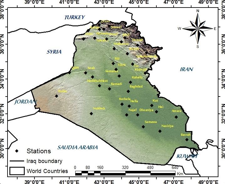
Monthly rainfall data for the period 2000-2021, obtained from the Iraq Meteorological and Seismological Organization (IMOS), were used to determine the average rainfall covering 38 rainfall stations in the study area. The details of these stations by geographical coordinates are presented in Table 1.
| Station No. | Station Name | Latitude (Degree) | Longitude (Degree) | Altitude (m) |
|---|---|---|---|---|
| 1 | Emadiah | 37.05N | 43.29E | 1236 |
| 2 | Sumeel | 36.86N | 42.85E | 250 |
| 3 | Rabiah | 36.48N | 042.06E | 382 |
| 4 | Tel-Afer | 36.22N | 042.29E | 373 |
| 5 | Sinjar | 36.19N | 041.50E | 476 |
| 6 | Ducan | 36.12N | 44.92E | 276 |
| 7 | Zakho | 37.08N | 042.41E | 442 |
| 8 | Duhook | 36.52N | 043.00E | 276 |
| 9 | Salahaddin | 36.37N | 044.13E | 1088 |
| 10 | Mosul | 36.19N | 043.09E | 223 |
| 11 | Erbeel | 36.09N | 044.00E | 420 |
| 12 | Makhmoor | 35.45N | 043.36E | 270 |
| 13 | Sulaimaniya | 35.33N | 045.27E | 853 |
| 14 | Kirkuk | 35.28N | 044.24E | 331 |
| 15 | Baiji | 34.56N | 043.29E | 150 |
| 16 | Tuz | 34.53N | 044.39E | 220 |
| 17 | Tikrit | 34.34N | 043.42E | 107 |
| 18 | Ana | 34.28N | 041.57E | 150 |
| 19 | Al-Kaem | 34.23N | 041.01E | 178 |
| 20 | Kanaqin | 34.18N | 045.26E | 202 |
| 21 | Samaraa | 34.11N | 043.53E | 75 |
| 22 | Haditha | 34.04N | 042.22E | 140 |
| 23 | Al-Khalis | 33.50N | 044.32E | 44 |
| 24 | Heet | 33.38N | 043.45E | 58 |
| 25 | Ramadi | 33.27N | 043.9E | 48 |
| 26 | Baghdad | 33.14N | 044.14E | 34 |
| 27 | Rutbah | 33.02N | 040.17E | 615 |
| 28 | Karbalaa | 32.37N | 044.01E | 29 |
| 29 | Kut | 32.30N | 045.49E | 19 |
| 30 | Hella | 32.27N | 044.27E | 27 |
| 31 | Kut-Al-Hai | 32.10N | 046.03E | 15 |
| 32 | Nukaib | 32.02N | 042.15E | 305 |
| 33 | Najaf | 32.01N | 44.20E | 53 |
| 34 | Diwaniya | 31.59N | 044.59E | 20 |
| 35 | Amarah | 31.51N | 047.10E | 9 |
| 36 | Semawa | 31.18N | 045.16E | 6 |
| 37 | Nasiriya | 31.05N | 046.14E | 3 |
| 38 | Basra | 30.34N | 047.47E | 2 |
Satellite data were used to identify the NDVI values and the spatial distribution of vegetation cover during the study period using ArcMap 10.4.1 software. NASA’s Earth satellite used MODIS (Land/Aqua) satellite data to make NDVI images for the years 2000 to 2021. For this study, 264 monthly satellite images were downloaded and analyzed, with 22 images covering the entire study area used for each year of the study period. The study examined the temporal and spatial variations of the NDVI index and its responses to rainfall, using satellite observation from the last two decades in Iraq. The use of MODIS NDVI data instead of higher-resolution alternatives can be justified based on several factors. MODIS provides continuous NDVI data from 2000 to the present, with regular updates. MODIS with spatial resolution (500 m or 1 km) is suitable for large-scale regional studies. If the purpose of the study is to analyze general trends and large-scale changes in a country such as Iraq, MODIS resolution is sufficient and less complex to manage. MODIS data is small, making it faster and easier to analyze. MODIS provides composite data that reduces the effect of clouds. In arid or semi-arid regions, such as Iraq, where seasonal clouds can occur, MODIS data may be more appropriate.
Rainfall maps for the research area were generated utilising annual rainfall data from 38 climate stations within the ArcGIS 10.4.1 framework, employing the Kriging tool from the Spatial Analyst extension. Kriging is a geostatistical interpolation technique that estimates unknown values based on known data points, providing a more precise spatial prediction. It accounts for both the distance and the degree of variation between points to predict values at unmeasured locations. The general equation for the Kriging method (Goovaerts, 2019) is
(x) = λ₁ * Z(x₁) + λ₂ * Z(x₂) + … + λn * Z(xn)(1)
Where Z(x) is the estimated value at the unknown location. Z(x₁)، Z(x₂)، … Z(xn) are the known values at the surrounding locations. λ₁, λ₂, … λn are the Kriging weights assigned to each known value. n is the number of known points.
The Kriging method was chosen for spatial interpolation because of its strong geostatistical basis and its ability to provide accurate predictions in areas where the data distribution is irregular, such as rainfall. Kriging surpasses simpler interpolation algorithms in accuracy by taking into account the spatial autocorrelation among data points. This renders it particularly advantageous for analysing environmental phenomena, where spatial variations are significant. This method effectively produces smooth, precise maps of spatial distribution, which are crucial for environmental investigations requiring accurate visual representation. According to Katipotoğlu (2022), Kriging can assist decrease estimation mistakes by providing a variance map. This map indicates areas where the data is less reliable and aids in making more informed judgements regarding data interpretation and analysis.
NDVI indicates the size and vigour of vegetation in a specific location. It is utilised in remote sensing and Geographic Information Systems (GIS). (Li et al. 2021) assert that NDVI is calculated using aerial or satellite imagery to assess plant health and density. NDVI was first referenced in 1973, coinciding with the development of near-infrared (NIR) sensors for satellites (Rousta, 2022). The index is determined by the extent to which green plants reflect near-infrared light and absorb visible red light (Zhang, 2018). NDVI values range from -1.0 to 1.0. They are determined by calculating the difference between near-infrared reflectance and red reflectance relative to the sum of both bands. Negative values typically indicate snow-covered areas, clouds, or water bodies, while values approaching 1.0 represent dense forested regions (Muhammad et al., 2023).
NDVI = (NIR — Red) / (NIR + Red)(2)
Where RED and NIR (near infrared) are the spectral bands measured in the near infrared and red wavebands, respectively. A simple understanding of NDVI values is that a value greater than 0.6 would indicate healthy vegetation, and a value less than 0.6 but greater than 0 would indicate unhealthy vegetation. Values less than 0 can be water (Al-Khudhairy and Al-Timimi, 2021). Table 2 represents NDVI value variations according to surface coverage. Because of its stability, NDVI is an effective measure of vegetation that allows meaningful comparisons of interannual variations in vegetation growth and activity. The higher these ratios are, the more actively the plant grows (Al-Mazban, 2023). The territory of Iraq was defined using satellite imagery based on the administrative boundaries established by IMOS, and the NDVI satellite pictures were classed use ArcGIS.
| Vegetation cover type | Categories |
|---|---|
| Non-existent | >0 |
| Low density | 0.2-0.0 |
| Medium density | 0.7-0.3 |
| Dense | 1-0.8 |
Two different statistical analysis approaches have been used. The first is the Pearson correlation coefficient, which is defined as a statistical measure that expresses the degree and strength of the relationship between the two variables used in this study. Table 3 shows the classifications of this factor, which will be adopted to clarify the relationship between the two variables whose relationship is being studied (Hamad et al., 2022). The second is a trend line, which is a line drawn above the highs or below the lows to show the dominant direction of the data. The more points there are to connect, the stronger the trend line becomes (Al-Jasani and Abdullah, 2023). A line in charts is used to indicate the direction of data over a given period. It is plotted on the graph to illustrate a general trend, which may show an increase, decrease, or stability in the data (Abdulla, 2019). This line can be used to predict future values. A trend line can tell if the health of the vegetation is improving, deteriorating, or remaining constant (Wang et al., 2020).
| R | Correlation level |
|---|---|
| 0.00 | No correlation |
| 0.00-0.25 | Very weak correlation |
| 0.25-0.50 | Enough correlation |
| 0.50-0.75 | Strong correlation |
| 0.75-0.99 | Very strong correlation |
| 1.00 | Perfect correlation |
2.3.4. Spatial pattern analysis using Moran’s Index (I)
This study employed spatial correlation analysis to examine the distribution of climate and environmental variables, determining whether they are clustered, randomly dispersed, or diverging. The Global Moran’s Index was employed, a recognized method for assessing the spatial correlation of the values of the studied phenomenon across several locations. It aids individuals in comprehending the distribution of environmental and meteorological variables, such as precipitation and vegetation cover, within a region. It can also assist in determining whether elements are uniformly distributed within a specific area. It corroborates the results of other studies, such as elucidating the correlation between NDVI and rainfall, and furnishes a scientific foundation for comprehending the region’s environmental and climatic impacts. This equation (Wang et al., 2020) is utilized to calculate the Moran index:
(3)
Where I: is the Moran’s index, which measures spatial correlation. n: is the number of geographical locations (pixels or climate stations). and are the values of the variable (such as rainfall or NDVI) at locations i and j. is the arithmetic mean of values across all locations. is the spatial weight matrix that determines the relationship between different geographic locations.
If I > 0, it shows a clustered pattern with values that are comparable to one another. If I < 0.05, it suggests a dispersed pattern with surrounding values differing from one another. I=0 suggests a random distribution, which means there is no discernible spatial structure.
2.3.5. Variogram assessment (Model Validation sections)
The variogram model is a statistical model that describes how spatial values vary with distance. Kriging uses frequencies to assess the link between geographically spread points in the field and enhance prediction accuracy. Kriging results may be erroneous or unreliable in the absence of frequency analysis. To confirm the accuracy of the Kriging model employed in this study, a frequency analysis was conducted to determine the spatial relationship between points. The empirical frequencies were generated in ArcGIS and then fitted to the semivariogram model. The frequencies model had the best match to the data, with extracted values for Nugget, Range, and Sill aligning with the geographic structure. The model was cross-validated to ensure the accuracy of the estimations and the efficacy of Kriging in producing high-quality maps. The following Fig. 2 incorporates the steps that were followed in this research.
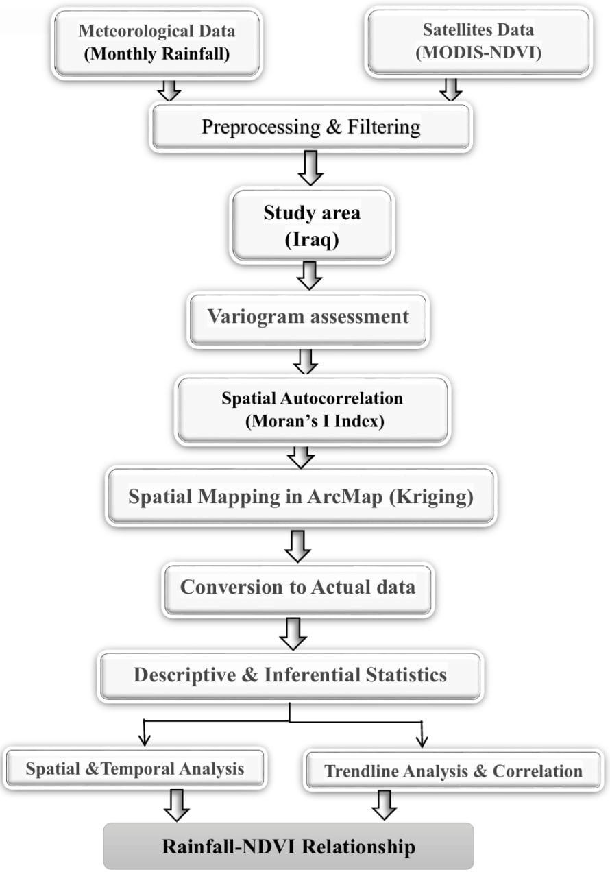
Fig. 3 illustrates the temporal analysis of NDVI and rainfall in the study area from 2000 to 2021. The data demonstrates a clear correlation, showing that years with lower rainfall levels typically correspond to decreased NDVI values. This time series is particularly evident in 2008, which stands out as a drought year due to the significant decline in both rainfall and NDVI. The values range between 0.152 (2008) and 0.308 (2019). It can be seen that most years have low NDVI values, indicating low vegetation density. The NDVI increased significantly in 2019 (0.308) and 2020 (0.250), indicating that the vegetation density in these years was moderate. This may be the result of favorable environmental factors, such as increased rainfall or improved weather conditions. The years with the lowest NDVI values were 2000 (0.11) and 2008 (0.15). During these times, conditions such drought or little rain are unfavorable for plantation.
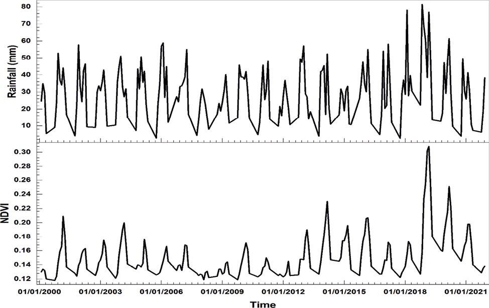
Fig. 4 shows how Iraq’s Normalized Difference Vegetation Index (NDVI) changes monthly from 2000 to 2021. It focuses on January through April, the best months for plants to thrive. The NDVI has a distinct seasonal pattern: it goes up during the wet season (November to April) and down during the dry season (May to October). NDVI readings are usually highest between February and April when the weather is best for growth because it rains more and the temperatures are moderate. However, Table 4 shows they drop significantly during the summer months (June to August).
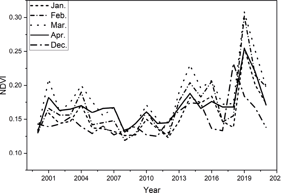
The results showed that the vegetation cover changed significantly during the study period. Perhaps, in addition to man-made pressures, the main reason is the natural changes caused by successive droughts. NDVI values increased over time, especially between 2018 and 2019, reaching 0.35, which may indicate unusually wet periods or improved vegetation growth conditions during those years or new agricultural projects. Conversely, in early years (2000–2010), values appear to follow a fairly consistent seasonal pattern, while later years show greater variability, possibly reflecting the effects of climate change or changes in land management, which may indicate unusually wet periods or improved vegetation growth conditions during those years.
Fig. 5 shows the time series of rainfall and the NDVI during 22 years. It can be observed that there is a correlation between rainfall and NDVI, meaning that as rainfall increases, NDVI values rise accordingly. It is also evident that 2018 experienced a significant amount of rainfall, as the graph displays a substantial increase in rainfall that year, marking the highest recorded during the specified period. An increase in rainfall is associated with an increase in NDVI values, indicating a positive effect of rainfall on vegetation. It can also be observed that periods of reduced rainfall coincide with a decrease in the NDVI index. The results showed that the lowest NDVI value, 0.152, occurred in 2008. This year marked the driest period, with the lowest recorded rainfall of 165 mm. In contrast, the highest NDVI value, 0.308, was observed in 2019. This year also had the highest rainfall rate, representing one of the peak records during the study period.
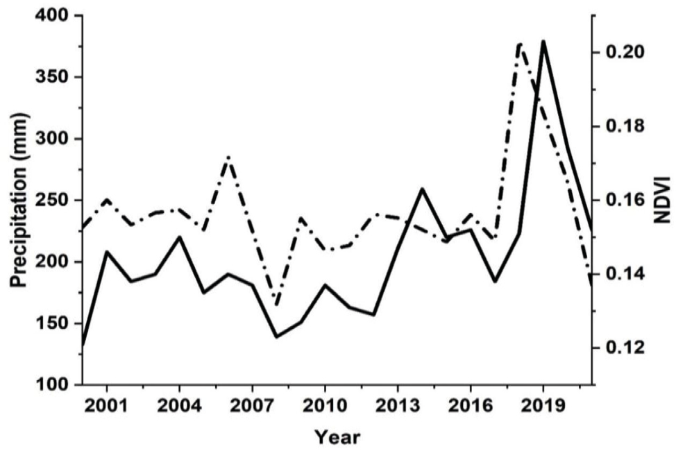
Fig. 6 shows the Normalized Difference Vegetation Index (NDVI) values for 38 locations in Iraq. The total distribution of NDVI demonstrates a definite pattern that reflects Iraq’s prevalent environmental and climatic effects. The graphic illustrates that the highest NDVI values are centered in the northern regions, gradually decreasing towards the center and south. Stations in the north have high NDVI readings, reaching 0.35. The northern regions have comparatively significant rainfall amounts compared to the rest of Iraq, ranging from 400 to 900 mm annually. Temperatures are lower than in southern locations, allowing soil moisture to be retained for longer periods of time. Stations in the center, on the other hand, show lower values as rainfall rates gradually decrease to 120 mm per year, diminishing the availability of natural water for plant development. The Tigris and Euphrates rivers sustain vegetation, but urban growth and seasonal crops lessen natural vegetation density in these places. The southern sections are classified as semi-arid to desert, with annual rainfall below 100 mm, which is insufficient to maintain natural vegetation. High temperatures, which can exceed 50°C in the summer, cause rapid water evaporation, which limits plant development. Soils in the southern regions are salinized and drought-prone due to little rainfall and high evaporation rates, resulting in lower NDVI values. The graph depicts a strong gradient in NDVI values from north to south across Iraq, indicating climatic and environmental differences.
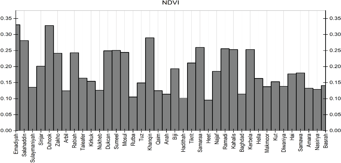
Table 4 summarizes the average values of NDVI and rainfall for each station for the duration of the study, providing a nuanced understanding of the dynamic response of vegetation to rainfall variations. Based on this table, Emadiah has the highest NDVI value (0.33) with a mean rainfall of 606.2 mm. This suggests that areas with dense vegetation are generally associated with higher rainfall levels. In comparison, Duncan, which has the highest rainfall (624.41 mm), shows a slightly lower NDVI value (0.249). This indicates that while rainfall significantly promotes vegetation growth, NDVI is not solely dependent on rainfall and can be influenced by other factors, such as soil type, temperature, and type of vegetation cover.
| Station No. | St. name | NDVI | Rainfall (mm) |
|---|---|---|---|
| 1 | Emadiah | 0.33 | 606.2 |
| 2 | Sumeel | 0.251 | 434.23 |
| 3 | Rabiah | 0.243 | 339.23 |
| 4 | Tel-Afer | 0.164 | 308.82 |
| 5 | Sinjar | 0.201 | 331.82 |
| 6 | Ducan | 0.249 | 624.41 |
| 7 | Zakho | 0.242 | 526.22 |
| 8 | Duhook | 0.328 | 487.52 |
| 9 | Salahaddin | 0.281 | 451.56 |
| 10 | Mosul | 0.244 | 358.41 |
| 11 | Erbeel | 0.124 | 392.87 |
| 12 | Makhmoor | 0.137 | 292.7 |
| ١3 | Sulaimaniya | 0.135 | 595.7 |
| 14 | Kirkuk | 0.154 | 337.8 |
| 15 | Baiji | 0.193 | 194.44 |
| 16 | Tuz | 0.149 | 269.56 |
| 17 | Tikrit | 0.211 | 162.64 |
| 18 | Ana | 0.114 | 124.32 |
| 19 | Al-Kaem | 0.125 | 118.8 |
| 20 | Kanaqin | 0.29 | 287.51 |
| 21 | Samaraa | 0.26 | 153.19 |
| 22 | Haditha | 0.103 | 115.9 |
| 23 | Al-Khalis | 0.253 | 171.77 |
| 24 | Heet | 0.096 | 110.47 |
| 25 | Ramadi | 0.256 | 107.51 |
| 26 | Baghdad | 0.114 | 120.47 |
| 27 | Rutbah | 0.105 | 106.13 |
| 28 | Karbalaa | 0.253 | 90.32 |
| 29 | Kut | 0.153 | 139.2 |
| 30 | Hella | 0.163 | 105.72 |
| 31 | Kut-Al-Hai | 0.177 | 131.11 |
| 32 | Nukaib | 0.126 | 76.17 |
| 33 | Najaf | 0.185 | 94.2 |
| 34 | Diwaniya | 0.138 | 101.95 |
| 35 | Amarah | 0.133 | 173.63 |
| 36 | Semawa | 0.18 | 99.12 |
| 37 | Nasiriya | 0.129 | 119.93 |
| 38 | Basra | 0.141 | 126.49 |
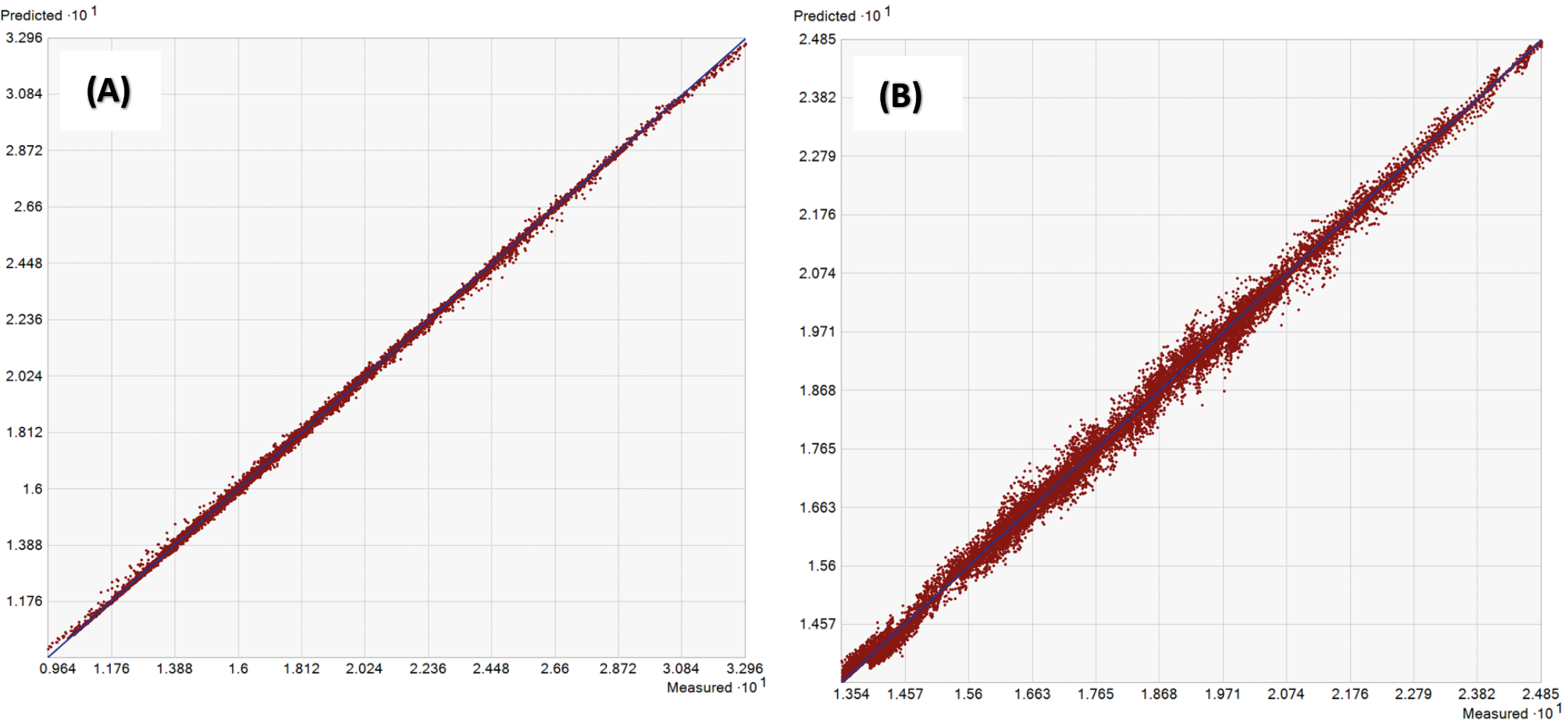
Fig. 7 (right), the points follow the main trend line but with a clear distribution, which means that kriging shows a more complex response to the data, as it can handle trends and spatial variations. IDW, although it provides accurate results, does not take into account spatial relationships, such as location variation. Kriging shows a greater ability to capture spatial patterns because it is more complex than IDW, and this allows it to better handle spatial trends. Since this study looks at differences in space and time and tries to find out how rainfall and NDVI are related across Iraq, it is essential to use a geostatistical method to account for both. Geographic factors, such as terrain, have a significant effect on rainfall. NDVI shows how vegetation responds to available moisture but doesn’t necessarily show how much rain fell. The researchers used the Kriging interpolation method to better understand how this relationship changes over space. Kriging is a way to guess values in locations where we don’t have measurements by using the connections between known data points. This practice makes it easier to get a fuller and accurate picture of the variables being researched.
As shown in Fig. 8, the spatial distribution of NDVI values was analyzed using the semivariogram model to assess the degree of spatial autocorrelation of vegetation cover. The semivariogram indicates that the nugget effect is approximately 0.00347, suggesting a low level of random variation or measurement error, possibly due to sensor noise or local-scale heterogeneity not captured at the resolution used. The partial sill, estimated as 0.00135, reflects the structured spatial variance, whereas the range of approximately 4.35 degrees denotes the spatial extent beyond which NDVI values are no longer spatially correlated. A stable semivariogram model was fitted to the experimental data, resulting in a reasonable fit, as evidenced by the alignment of the binned empirical values with the fitted model curve. The spatial pattern was discovered to be isotropic, meaning that spatial dependency in NDVI values is consistent in all directions. These findings indicate the presence of a distinct spatial structure in NDVI data, hence confirming the use of geostatistical interpolation techniques such conventional Kriging for spatial prediction. The geographical dependence seen within the specified range allows for credible interpolation of vegetation cover in unsampled areas, resulting in more accurate and meaningful environmental evaluations and land cover monitoring.
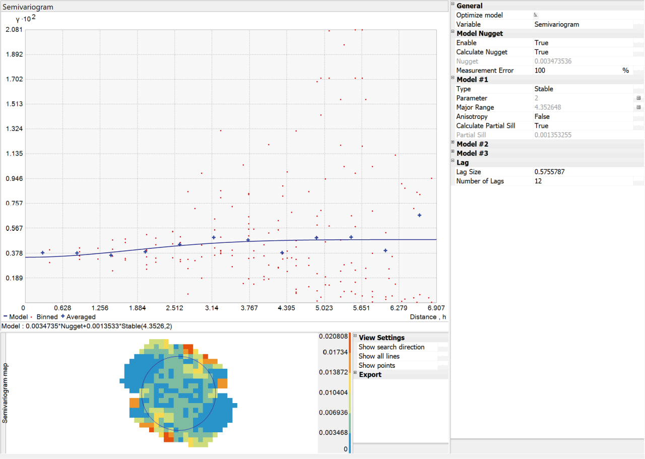
In this research, the spatial interpolation of both rainfall and NDVI was performed using the ordinary Kriging method, which is widely recognised for its effectiveness in modeling spatial continuity. The spherical semivariogram model was chosen because it matched the data’s spatial pattern the best, shown by having the lowest Root Mean Square Error (RMSE) in the cross-validation process. The semivariogram model parameters were as follows: Nugget: 0.00347, Sill: 0.00135, Range: 4.3526. These values indicate a moderate spatial dependency among the data points.
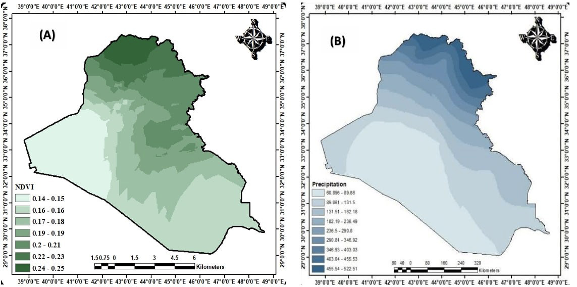
Fig. 9 presents the spatial distribution patterns of both rainfall and NDVI across the study area. These maps allow for a visual comparison between the two variables and help identify potential zones where higher or lower values might correspond. It offers a spatial context that supports further statistical analysis of their relationship. The NDVI map shows that the northern and eastern parts of Iraq have higher vegetation cover than the southern and western parts. This distribution makes sense with the geography since the northern part contains mountains and a humid environment. Figure 9B shows how rain falls over the country. The northern and eastern parts of Iraq get more rain than the southern and western parts (Muter et al., 2025). The weather of Iraq is like this; however, the northern part has a humid environment since the mountains are so high. It looks like the areas with a lot of rain on this map match up well with the areas with a lot of plants on the NDVI map. This means that rain is a big part of figuring out how dense the vegetation is in Iraq.
3.3. Spatial correlation analysis of rainfall and NDVI using Moran’s Index
The purpose of this analysis is to examine the regional pattern of rainfall and the NDVI using Moran’s I, a statistical metric that indicates whether the spatial values of a given variable are randomly distributed, clustered, or scattered. Fig. 10 illustrates the spatial correlation analysis of both rainfall and NDVI using Moran’s model. This analysis uses statistical values (Moran’s I, Z-score, and p-value) to assess whether the spatial distribution is associated or random. Moran’s I for rainfall is 0.711, showing significant geographical clustering of rainfall. The Z-score value of 11.578 indicates that the spatial distribution of rainfall is not random. The statistical significance level (p-value) was zero, which is a very low statistical value (<0.01), well below 0.01, confirming that this clustered pattern is not the result of chance but rather reflects the influence of climatic and geographical factors on rainfall distribution in the study area. The spatial maps reveal a clear grouping of heavy rainfall and dry areas close together, indicating that climatic systems have a substantial influence on rainfall distribution. Rainfall distribution appears to be clustered rather than random. There is a strong spatial association between neighbouring values, as stations with high rainfall rates tend to be close, and stations with low rainfall rates tend to be close.
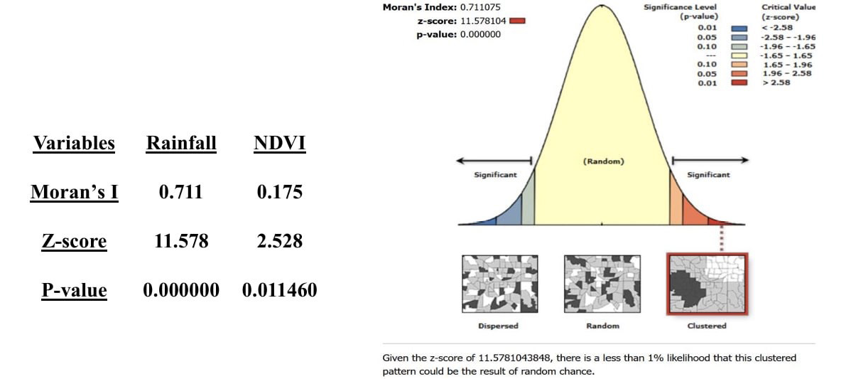
This demonstrates the impact of climatic and geographical conditions. In terms of spatial distribution, Moran’s I for the NDVI index was 0.175, which is a comparatively low value when compared to rainfall, showing that the natural vegetation index clusters less spatially. The Z-score of 2.528 was low but still within the statistically significant range, showing some clustering but not as strong as rainfall. The statistical significance level (p-value) was 0.011460, less than 0.05, indicating that this clustered pattern is not due to chance. These extra elements could make it more changeable and less clear than the rainfall distribution. The NDVI index doesn’t cluster as strongly as rainfall does in space. This is because other things, like soil type, land use, human involvement, and artificial irrigation, can alter vegetation cover without affecting rainfall. The Moran’s rainfall index is much higher than the natural vegetation index, which means that rainfall is more evenly spread out over space.
The natural vegetation index is more spread out, which shows the area’s ecological and human activity diversity. When looking at how climate and vegetation cover are associated in the context of environmental and climate changes, it might be helpful to tell the two distribution patterns apart. This study helps us learn more about the link between climate and vegetation cover. This lets us figure out how climate change affects ecosystems and how to take care of the environment.
Fig. 11A shows the yearly relationship between NDVI and rainfall. The link between vegetation index and rainfall depends a lot on how the weather changes in a certain area and how it affects plant development. The correlation coefficient between rainfall and the vegetation index is 0.5. This means that there is a fairly positive association between the two variables, but it is not strong enough to be a reliable predictor of how one variable would behave in respect to the other. Since the correlation coefficient is positive, this indicates that the relationship between the two variables is a direct relationship. That is, when one variable increases, the other variable is likely to increase as well. Since the dispersion between values, the relationship between the two variables is not perfect. This means that in addition to rainfall, there are other factors that affect vegetation, such as temperature, soil quality, and human interventions (such as agriculture and urbanization).
Figure 11B shows how rainfall and NDVI in Iraq have changed during the past 22 years. So, this map shows us how much rain influences plant growth in different parts of Iraq. Over the past ten years, Iraq has had a lot of droughts and rain that has changed a lot (Muter et al., 2024). This could change how rainfall and NDVI relate to each other in space. There is a good link between NDVI and rainfall. These places are mostly in northern Iraq, a hilly region known for heavy rain and thick vegetation. Areas with more rain have higher NDVI values, meaning the vegetation cover is denser. It can be seen how rivers affect NDVI because green spots occur along riverbanks when there is water. This map emphasizes the importance of rainfall in determining vegetation density in Iraq. This map can be used as a tool for planning water and agricultural resource management in Iraq. Low values represent areas with a weak or negative relationship between rainfall and NDVI. These areas are concentrated in the southern and western regions, where rainfall is lower and the environment is drier; the relationship between rainfall and NDVI may be weaker where rainfall is scarce and vegetation cover is less dense. Negative values may indicate areas where vegetation thrives in the absence of rainfall, thereby elucidating the reliance on alternative water sources such as irrigation or groundwater.
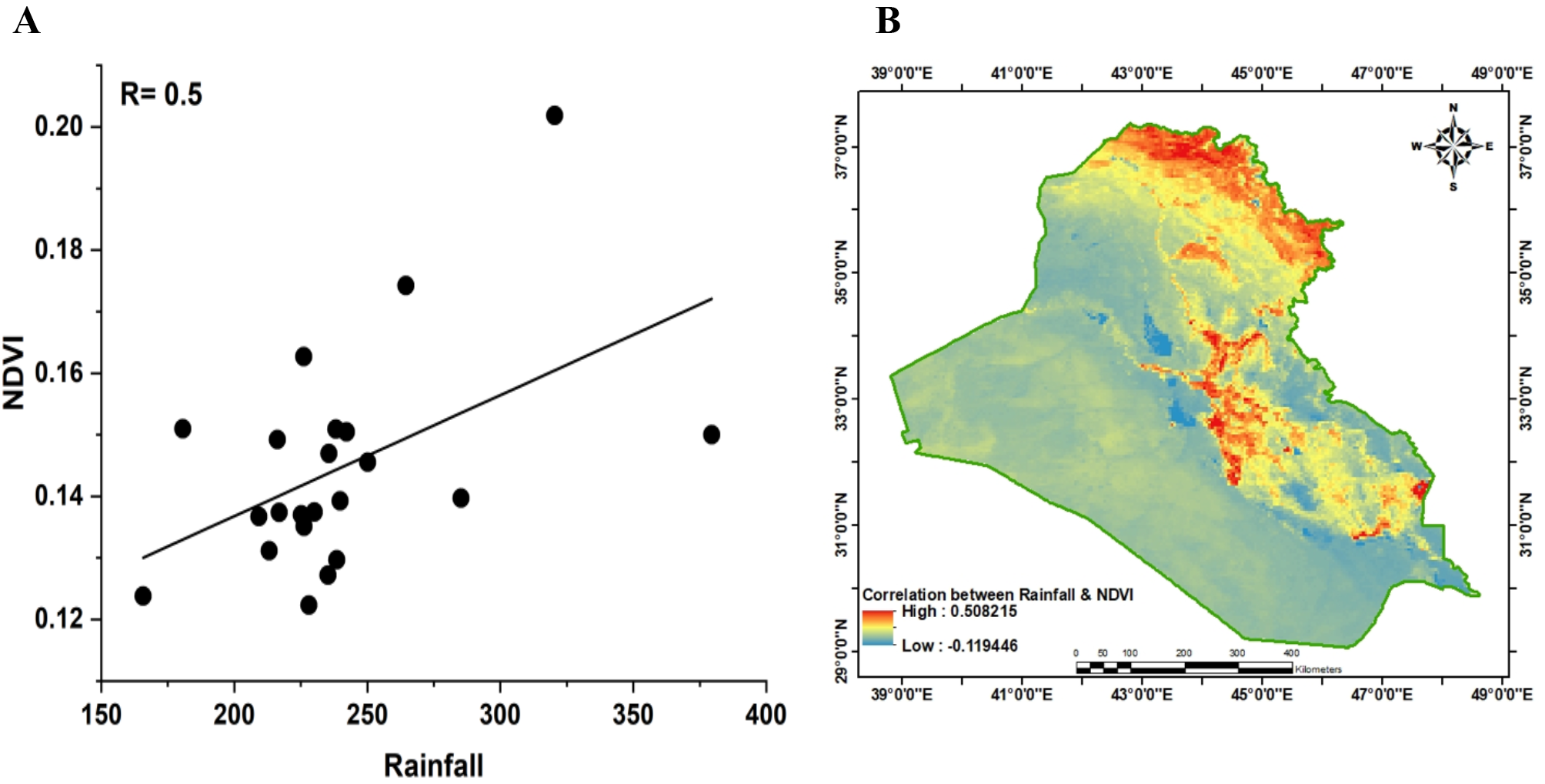
From 2000 to 2021, irrigated agriculture grew in various parts of Iraq, especially in the south. These actions may have lessened the effect of low rainfall on NDVI, which could explain why the link between rainfall and vegetation is different. The wars and conflicts that Iraq went through at that time changed the way people used land, which changed the vegetation cover. For instance, the Ducan station, which gets an average of 624.41 mm of rain and has an NDVI of 0.249, may be linked to thick vegetation. On the other hand, stations with minimal rainfall, such Nukhaib (76.17 mm), had low NDVI values of 0.126. The stations are spread out over different areas, which means that the amount of rain and NDVI varies from one area to another. Local factors including plant habitat, soil, and climate have an effect on this diversity.
This study effectively elucidates the relationship between vegetation cover and rainfall across various terrains and climates. Conversely, Al-Hasn (2024) examines the impact of drought on vegetation cover in arid regions, providing further insights into environmental issues in both nations. The little correlation between rainfall and NDVI in Iraq, in contrast to recent regional studies (Al-Hasn, 2024), may result from a combination of environmental, topographical, climatic, and anthropogenic factors. The climate in Iraq is diverse, encompassing deserts, semi-arid regions, and agricultural areas. The majority of these locations are situated in arid or semi-arid environments, where vegetation exhibits minimal responsiveness to rainfall. In arid regions, vegetation relies on the moisture present in the soil. Plants in these regions have adapted to harsh conditions, hence they have a diminished response to precipitation compared to flora in temperate regions. Rainfall in Iraq is irregular both spatially and temporally, typically occurring within a brief duration throughout the winter and spring seasons.
Human activities such as unsustainable agriculture, deforestation, and urbanization have weakened the relationship between NDVI and rainfall. Iraq suffers from a shortage of freshwater and the reduced flow of its main rivers (Tigris and Euphrates) due to dams and regional water policies. The limited availability of surface water and groundwater makes plants more dependent on these sources than on rainfall, resulting in a weak relationship between NDVI and rainfall. The variety of soil types in Iraq affects the soil’s ability to store and use water. Climate change and rising temperatures in Iraq are increasing evaporation rates, reducing the impact of rainfall on soil moisture and plant growth.
The geographical distribution of sites analyzed in this study highlights notable differences in rainfall and NDVI across various regions of Iraq. A positive relationship is evident between rainfall and NDVI, with a correlation coefficient of 0.5, but the relationship is not perfectly linear, and variations can be seen between different locations. This indicates that while increased rainfall generally enhances vegetation abundance and activity, other factors also influence these variables. Regions in the north and east, characterized by higher rainfall, typically support denser vegetation compared to the drier south and west, a pattern consistent with Iraq’s geographical reality, where the northern areas have mountainous terrain and a more humid climate. The study identified 2018 as an anomalous year, marked by the heaviest rainfall in recent years, which sparked further research interest. A lag was observed in the vegetation’s response to rainfall, as plants require time to grow following rainfall. There were clear seasonal changes in vegetation. NDVI was highest in February, March, and April and lowest in the summer months in June, July, and August. The year with the least rain was 2008, with an NDVI value of 0.152 and 165 mm. The year with the most rain was 2019, with an NDVI value of 0.308 and one of the highest rainfall rates of the research period. The study also shows how helpful maps can be for designing farms since they help farmers find regions where crops grow well based on how much rain falls there. These maps can also be helpful in climate change studies since they show how vegetation and rainfall patterns change over time in different areas. Also, combining NDVI with RS provides a cheap way to keep an eye on vegetation cover in Iraq, which helps with managing natural resources. Finally, MODIS satellite photos worked well for finding global drought indicators, which made it possible to figure out how bad a drought was in places without ground-based measurements.
The amount and distribution of rainfall have big effects on farming, managing water resources, and planning for the environment. This is because stations with more rainfall are more likely to have lush vegetation and higher agricultural production. In contrast, areas with lower rainfall may face water scarcity and drought issues. Rainfall has a distinct clustered spatial pattern that reflects climatic and geographic effects, with wet and dry areas clearly converging. However, the NDVI score has a less defined regional distribution because of additional natural and anthropogenic influences. The substantial difference between Moran’s I for rainfall (0.711) and NDVI (0.175) suggests that rainfall has a more uniform spatial distribution than vegetation, which is more variable due to non-climatic variables. It was observed that rainfall exhibits a more homogeneous spatial pattern, whereas the NDVI is influenced by multiple factors, resulting in a less uniform spatial pattern.
The authors would like to express their sincere gratitude to Mustansiriyah University for their continuous support and for providing an academic environment that fostered their research. My appreciation also extends to the Iraqi Meteorological Organization and Seismology (IMOS), Ministry of Transport, for providing essential meteorological data that contributed to this study. Additionally, I would like to thank NASA for supplying the Terra MODIS NDVI dataset.
Abdulla H.J., 2019. Manifestations of climate change in Baghdad Area. Al-Mustansiriyah J. Sci., 30 (4): 39-42. DOI: https://doi.org/10.23851/mjs.v30i4.657
Almamalachy Y.S., Al-Quraishi A.M.F., Moradkhani H., 2020. Agricultural Drought Monitoring Over Iraq Utilizing MODIS Products. In: Al-Quraishi, A., Negm, A. (eds) Environmental Remote Sensing and GIS in Iraq. Springer Water. Springer, Cham. https://doi.org/10.1007/978-3-030-21344-2_11
Abdul Jabbar A.M., Abdulkareem A.K., 2021. Predicted the Cumulative Annual Rainfall in Iraq using SDSM Modal. Al-Mustansiriyah J. Sci., 32(2): 11-17. https://doi.org/10.23851/mjs.v32i2.977
Abdulkareem I.H, Nemah H.A., 2021. Variation of Weather Elements during Different Seasons in Iraq. Journal of Engineering Science and Technology, 16 (6): 5000-5012. https://dx.doi.org/10.1088/1755-1315/1223/1/012002
Al-Khudhairy A.A., Al-Timimi Y.K., 2021. Analysis of the LST and Vegetation Indices relationship using Landsat-8 data in Duhok Governorate, Iraq. Al-Mustansiriyah J. Sci., 32, (4). DOI: http://doi.org/10.23851/mjs.v32i4.1012
Al-Jasani N.A.A., Abdullah H.N.N., 2023. Geographical analysis of the variation of the standard vegetation index “NDVI” and its characteristics in the Najaf Governorate for the summer season. Anbar University Journal of Human Sciences, 1: 327-350. http://search.mandumah.com/Record/1386106
Al-Lami A. M., Khaleed O. L., Ahmed M. M., 2023. Assessment of some Bioclimatic Indices using RayMan Model for Baghdad-Iraq. IOP Conf. Ser.: Earth Environ. Sci. 1223, 012019. https://doi.org/10.1088/1755-1315/1223/1/012019
Al-Mazban M.T.Q., 2023. The impact of climatic changes on the vegetation cover difference index in eastern Maysan governorate. Journal of Education College Wasit University, 50 (1): 271-281. https://doi.org/10.31185/eduj.Vol50.Iss1.3433
Al-hasn R., 2024. Studying correlation between rainfall and NDVI/MODIS for Time Series (2012–2022) in Arid Region in Syria. Environmental Sciences Proceedings 29, 1: 58. https://doi.org/10.3390/ECRS2023-16704
Al-Daoudi A.S., Al-Timimi Y.K., 2024. Monitoring of Iraq Vegetation Dynamics Using MODIS Data From 2000-2023. IOP Conference Series: Earth and Environmental Science, 1371 (2): 1755-1315. https://dx.doi.org/10.1088/1755-1315/1371/2/022033
Al Rukabie J. S. A., Naif S. S., Al-Jiboori M. H., 2024. Quantitative Impact of Monthly Precipitation on Urban Vegetation, Surface Water and Potential Evapotranspiration in Baghdad Under Wet and Dry Conditions. Nature Environment and Pollution Technology, 23:4, 2383-2389. https://doi.org/10.46488/NEPT.2024.v23i04.041
Deagan E. M., Al-Jiboori M.h., 2023. The Relationship of CLWC and Rainfall to the Synoptic Cases of Two Case Studies Over Iraq. IOP Conf. Series: Earth and Environmental Science, 1262: 082038. https://doi.org/10.1088/1755-1315/1262/8/082038
Goovaerts, P., 2019. Geostatistical estimation methods: Kriging. In P. Bogaert, M. Saïd, & P. Goovaerts (Eds.), Geostatistics for Environmental Applications: 221–244. Springer. https://doi.org/10.1007/978-3-030-17860-4_16
Guo E., Wang Y., Wang C., Sun Z., Bao Y., Mandula N., Jirigala B., Bao Y., Li H., 2021. NDVI Indicates Long-Term Dynamics of Vegetation and Its Driving Forces from Climatic and Anthropogenic Factors in Mongolian Plateau. Remote Sensing 13, 4: 688. https://doi.org/10.3390/rs13040688
Gaznayee H.A, Al-Quraishi A.M.F., Karrar M., and Coen R., 2022. A Geospatial Approach for Analysis of Drought Impacts on Vegetation Cover and Land Surface Temperature in the Kurdistan Region of Iraq. Water, 14, (6): 927. https://doi.org/10.3390/w14060927
Hamad A. I., Ali A. B., Hassoon A. F. 2022. Climate change and its effect on water and vegetation cover over sharp regions using GIS techniques. AIP Conf. Proc. 2398 (1): 020055. https://doi.org/10.1063/5.0097668
Helali J., Asaadi S., Jafarie T., Habibi M., Salimi S., Momenpour S.E., Shahmoradi S., Hosseini S.A., Hessari B., Saeidi V., 2022. Drought monitoring and its effects on vegetation and water extent changes using remote sensing data in Urmia Lake watershed, Iran. Journal of Water and Climate Change, 13 (5): 2107–2128. https://doi.org/10.2166/wcc.2022.460
Hatem I., Alwan I., Ziboon A., Kuriqi A., 2024. Assessment of agricultural drought in Iraq employing Landsat and MODIS imagery. Open Engineering, 14(1): 20220583. https://doi.org/10.1515/eng-2022-0583
Jaber S.H., Al-Saadi L.M., Al-Jiboori M.H., 2020. Spatial Vegetation growth and its relation to seasonal temperature and precipitation in Baghdad. Int. J. Agricult. Stat. Sci., 16 (1), 2021-2026. https://connectjournals.com/03899.2020.16.2021
Kadhum J.H., Al-Zuhairi M.F., Hashim A.A., 2022. Synoptic and dynamic analysis of few extreme rainfall events in Iraq. Earth Syst. Environ. 8: 4939–4952. https://doi.org/10.1007/s40808-022-01419-1
Katipoğlu O.M., 2022. Spatial analysis of seasonal rainfall using various interpolation methods in the Euphrates basin, Turkey. Acta Geophys. 70: 859–878. https://doi.org/10.1007/s11600-022-00756-0
Li P. J., Wang M., Liu Z., Xue A., Bagherzadeh M. Liu., 2021. Spatial-Temporal Variation Characteristics of NDVI and its Response to Climate on the Loess Plateau from 1985 to 2015. CATENA 203: 105331. https://doi.org/10.1016/j.catena.2021.105331
Mustafa Y.T., 2020. Spatiotemporal Analysis of Vegetation Cover in Kurdistan Region-Iraq using MODIS Image Data. J. Appl. Sci. Technol., 1: 01-07. https://doi.org/10.38094/jastt119
Mzuri R.T, Omar A.A., Mustafa Y.T., 2021.Spatiotemporal Analysis of Vegetation Cover and Its Response to Terrain and Climate Factors in Duhok Governorate, Kurdistan Region, Iraq. Iraqi Geological Journal, 54(1A). https://doi.org/10.46717/igj.54.1A.10Ms-2021-01-31
Muhammad R.A, Abbas A., Hussein S., 2023. Land cover changes in the Musayyib area-Babylon using remote sensing data and geographic information systems, Midad AL-Adab Refereed Quarterly Journal, 30: (3), Article 14. https://digitalcommons.aaru.edu.jo/midad/vol30/iss3/14
Muhammad B. J., Hassoun I. S., 2023. Rainfall and its impact on vegetation cover within Sulaymaniyah Governorate: (A comparative study for the period between (1992-1999). Journal of Educational and Human Sciences, 24: 125-44. https://doi.org/10.33193/JEAHS.24.2023.365
Muter S.A, Al-Timimi Y.K., Al-Jiboori M.H., 2024. Analysis of Temporal and Spatial Drought Characteristics in Iraq Using the Standard Rainfall Index (SPI). IOP Conference Series: Earth and Environmental Science, Pollution and Ecology, 1371. https://doi.org/10.1088/1755-1315/1371/2/022032
Mahdi Z.S., Abu-ALShaeer M.J., Al-Jiboori M.H., 2024. Quanti-native relationships among potential evapotranspiration, surface water, and vegetation in an urban area (Bagh-dad). Italian Journal of Agrometeorology (2): 81-88. https://doi.org/10.36253/ijam-2557
Muter S.A, Al-Jiboori M.H., Al-Timimi Y.K. 2025. Assessment of Spatial and Temporal Monthly Rainfall Trend over Iraq. Baghdad Science Journal; 22: 3, Article 17. DOI: https://doi.org/10.21123/bsj.2024.10367
Naif S.S., Mahmood D.A., Al-Jiboori M.H., 2020. Seasonal normalized difference vegetation index responses to air temperature and rainfall in Baghdad. Open Agriculture, 5, (1): 631-637. https://doi.org/10.1515/opag-2020-0065
Nassif W.G., Al-Ataby I.K., Al-Taai O.T., 2024. Impact of Soil Temperature and rainfall on Vegetation Cover Over Selected Stations in Iraq. Asian Journal of Water, Environment and Pollution, 21 (1): 25-33. https://doi.org/10.3233/AJW240005
Othman A.A., Shihab A.T., Al-Maamar A.F., Al-Saady Y.I., 2020. Monitoring of the Land Cover Changes in Iraq. Environmental Remote Sensing and GIS in Iraq. Springer Water. Springer, Cham. https://doi.org/10.1007/978-3-030-21344-2_8
Rousta I., Moniruzzaman M., Olafsson H., Zhang H., Baranowski P., Tkaczyk P., Lipińska H., Kępkowicz A., Krzyszczak J., 2022. Investigation of the Vegetation Coverage Dynamics and its Relation to Atmospheric Patterns in Kabul River Basin in Afghanistan. Pure and Applied Geophysics, 179: 3075-3094. https://doi.org/10.1007/s00024-022-03044-6
Wang J., Ouyang J., Zhang M. 2020. Spatial distribution characteristics of soil and vegetation in a reclaimed area in an opencast coalmine. CATENA, 195, 104773. https://doi.org/10.1016/j.catena.2020.104773
Zhang H., Chang J., Zhang L., Wang Y., Li Y., Wang X., 2018. NDVI dynamic changes and their relationship with meteorological factors and soil moisture. Environ Earth Sci, 77 (582). https://doi.org/10.1007/s12665-018-7759-x
Zheng K., Tan L., Sun Y., Wu Y., Duan Z., Xu Y., Gao C., 2021. Impacts of climate change and anthropogenic activities on vegetation change: Evidence from typical areas in China. Ecological Indicators; 126 (107648): 1470-160X. https://doi.org/10.1016/j.ecolind.2021.107648