https://doi.org/10.36253/asiana-3739
Kınık Höyük from the Middle Bronze Age to the Roman period: preliminary report on the excavation at the Lower Town 2023-2024
1 Università degli Studi di Firenze, Italy
2 Freie Universitaet Berlin, Germany
3 Brown University, USA
4 University of Toronto, Canada
5 Università di Pavia, Italy
6 Dokuz Eylül Üniversitesi | Resmi Web Sitesi, Türkiye
7 Mardin Artuklu University, Türkiye
*Corresponding author. Email: marina.pucci@unifi.it
Abstract. This article presents the second preliminary report on the excavations conducted in the Lower Town (Area D) of Kınık Höyük, located in the Bor Plain of southern Cappadocia. Recent fieldwork (2023–2025) has significantly refined the stratigraphic sequence previously proposed for this sector of the site. Through the integration of stratigraphic analysis, ceramic study, zooarchaeology, paleoethnobotany, and radiocarbon dating, the paper reconstructs a long-term occupational history spanning from the Middle Bronze Age to the Roman period. A major contribution of this research is the identification of a monumental Middle Bronze Age occupation (Phase 6), including fortifications and associated installations dated to the 18th century BC. This phase is followed by a period of contraction and partial abandonment in the Late Bronze Age, before a Middle Iron Age reoccupation (Phase 4) characterized by domestic architecture adapted to the Bronze Age ruins. Late Iron Age activity (Phase 3) reflects a functional reorganization of the area, with evidence for craft production and large-scale levelling. The Hellenistic phase marks a final reconfiguration of the Lower Town through terracing and limited domestic and artisanal occupation. By emphasizing patterns of continuity, rupture, and reuse in urban space, material culture, and subsistence practices, this study contributes to broader discussions on urban resilience, landscape memory, and the variable trajectories of secondary settlements in southern Cappadocia from the Middle Bronze Age through the Hellenistic period.
Keywords: Middle Bronze Age Anatolia, Kınık Höyük, excavation’s report, Iron Age Anatolia, pottery.
Contents
2. 2023-2024 Archaeological activities in the Lower Town
3. Area D general observations and phasing
4. The Middle Bronze Age town (Phase 6)
4a. Architecture and stratigraphy
4d. The in-situ pottery assemblage from Phase 6
5. From the Middle Bronze Age to the Middle Iron Age (Phase 5)
6. The Middle Iron Age reoccupation (Phase 4)
6a. Stratigraphy and architecture
6d. Pottery from Room Dr10 (Phase 4b)
6e. Pottery from Room Dr7 (Phase 4b)
7. The Late Iron Age organisation of the area (Phase 3)
7a. Stratigraphy and architecture
7d. Production Waste (Metal and Glass)
7e. Local Pottery from the installations’ filling (Phase 3a)
8. The Hellenistic Lower Town (Phase 2)
8a. The passage from Late Iron to Hellenistic Period (2b)
8b. The Hellenistic reoccupation (2a)
9. Post Hellenistic? Roman (Phase 1)
10b. From Middle Bronze urbanism to Hellenistic re-foundation: a punctuated history
1. Introduction
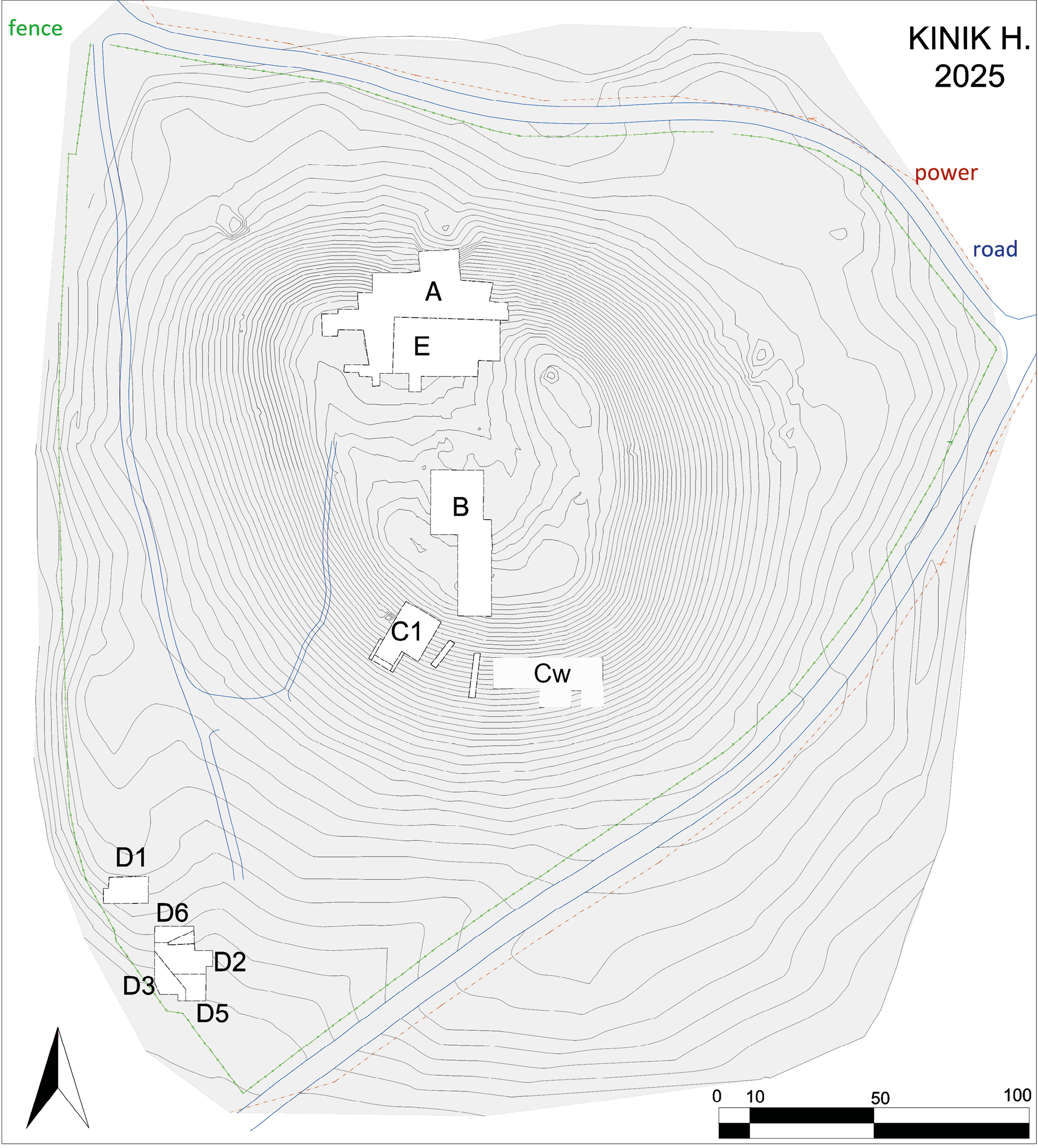
This article presents the second preliminary report on excavations in the Lower Town of Kınık Höyük, an archaeological mound in the Bor Plain (Niğde Province), southern Cappadocia (Fig. 1). Fieldwork at Kınık Höyük commenced in 2011 as a joint project of the University of Pavia and the Institute for the Study of the Ancient World (ISAW), New York University (dir. L. d’Alfonso), initially with the participation of Erzurum University and subsequently Dokuz Eylül University in Izmir. During the first decade, research concentrated on the Upper Town, Sector A, B, C and E (Iron Age and later periods) and on one sector of the Lower Town (D1) where Hellenistic levels were reached.1
Since 2022, under the direction of the University of Florence, in collaboration with Dokuz Eylül University, investigations have focused in the Lower Town with the aim of reconstructing the settlement’s social and cultural dynamics from the Middle Bronze Age (hereafter MBA) through the Hellenistic and Roman periods. In parallel, research on the acropolis has continued, with ongoing investigations by ISAW and the University of Pavia. The present report updates the results from the Lower Town, refining the phasing proposed in the previous preliminary report (Pucci et al. 2023). Material analyses and radiocarbon (¹⁴C) dating allow a firmer definition of the earliest phase, assigned to the MBA, and support the outline of the lower city as well as to ceramic analysis,2 faunal remains,3 paleoethnobotanical samples, and geological investigations.4 All authors contributed substantially to this article, each within their specific area of expertise.5
2. 2023-2024 Archaeological activities in the Lower Town
Archaeological activities in the Lower Town in 2023, 2024, and early 2025 pursued two objectives: (1) refining the stratigraphic sequence by enlarging the excavation in Area D; and (2) analysing selected classes of finds – principally ceramics, but also metallurgical slags, faunal remains, and paleoethnobotanical samples. Ceramic study followed a standard protocol whereby at least 20% of diagnostic sherds were fully documented for each stratigraphic unit (SU) in secondary deposits, and all diagnostic sherds were fully documented for primary contexts. Most effort over the last two seasons has focused on assemblages from the Middle Iron Age (MIA) and the MBA, whose two primary contexts underwent conservation and complete documentation.6 Faunal remains from selected SUs were analysed in the laboratories at the Mardin Artuklu University (dir. Prof. Siddiq), while botanical remains from specific SUs were processed in the field laboratory by Dr. Lorenzo Castellano.
In our first preliminary article (Pucci et al. 2023), we suggested that the earliest evidence at Kınık Höyük pre-dated the 10th century BC. Recent radiocarbon determinations, together with the study of a primary Phase 6 assemblage, now indicate that the most monumental occupation so far exposed in the Lower Town belongs to the MBA. Accordingly, the research emphasis has expanded to bring this horizon more fully to light and to clarify the subsequent history of abandonment and partial reoccupation. The aim of this paper is to provide a first overview of the sequence and an outline of the urban occupation of the Lower Town from the MBA to the Roman period.
3. Area D general observations and phasing
Area D is located in the SW sector of Kınık Höyük (Fig. 1). The area was selected for excavation in 2018 primarily because of its favourable topography. In modern times, a large pit for agricultural refuse had been cut into this part of the slope. The creation of this pit involved the mechanical removal of the upper portion of the plateau, which produced an open dumping space and left a lateral trench along its northern edge. This intervention stripped away the uppermost stratigraphic units (hereafter SU) and exposed a clean section through the slope, revealing earlier, undisturbed archaeological deposits (Fig. 2). Opening an excavation in this sector could afford direct access to earlier phases, yet the stratigraphy is partly truncated and markedly irregular.
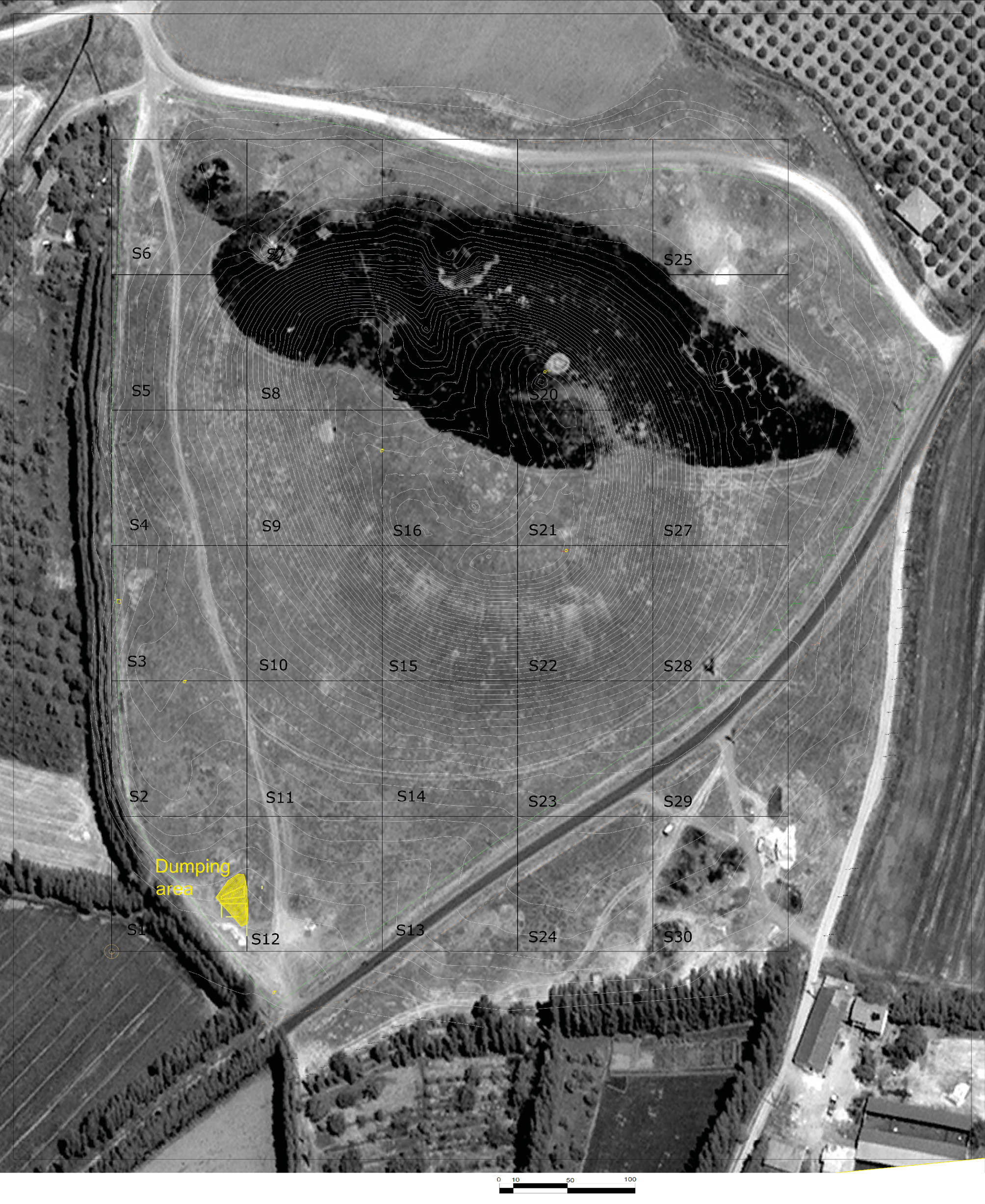
Area D is organised into several sub-sectors – D2 to D6 – which do not represent separate excavation areas (Fig. 1), but rather distinct working units within a single, continuous field operation. Over the course of the project, Area D has been progressively enlarged to the south, west, and north, each expansion driven by specific research objectives and practical considerations. The extensions to the south and west were undertaken to explore earlier architectural horizons, including monumental levels already exposed in this part of the Lower Town. By contrast, the enlargement to the north (D6) served a dual purpose: first, to begin establishing a stratigraphic connection with Area D1 (excavated 2011–2018); and second, to mitigate the formation of excessively high section , thereby improving both excavation safety and the clear structural and visual reading of the complete stratigraphic sequence in this sector.
This section presents the chronological sequence for Area D, first outlined in 2022 (Pucci et al. 2023) and revised here in light of newly acquired data. The definition of the local phases is based strictly on stratigraphic relationships and ceramic comparisons, while their absolute chronology is anchored on a set of radiocarbon (¹⁴C) determinations, two obtained in 2018–2019 and two recently produced. These combined lines of evidence provide the chronological framework that allows Area D sequence to be correlated reliably with the wider occupational history of the site. Table 1 below summarises the six phases identified (1–6), listing their approximate chronological attributions, available ¹⁴C dates, and broader correlations. Individual paleoethnobotanical ¹⁴C samples and their interpretative significance are discussed in detail within the respective phase narratives.
| Kınık Höyük Period | Conventional Period | Date | Operation D2-6 Phases |
|---|---|---|---|
| Modern Times | Phase 0 | ||
| KH-P I | Seljuk and Early Ottoman | 1200-1450 AD | - |
| KH-P II | Roman | 17 CE-? AD | Phase 1 |
| KH III | Hellenistic | 200-17 BC | Phase 2a |
| Achaemenid | 540-200 BC | Phase 2b hiatus | |
| KH-P IV | Late Iron Age | 7th -6th cent BC | Phase 3a |
| Phase 3b | |||
| KH-P VA | Middle Iron Age | ends around 750 BC begins in the 9th century (813-777 BC 14C) |
Phase 4a |
| Phase 4b | |||
| Phase 4c | |||
| KH-P VB | Early Iron Age | 1200-1000 BC | Phase 5 hiatus |
| KH-P VI | Late Bronze Age | 1600-1200 BC | |
| KH-P VII | Middle Bronze Age | 2000-1600 BC (1744-1612 BC 14C) |
Phase 6a-b |
| KH-P VIII | Early Bronze Age | Before 1744 BC | not reached |
In addition to the six main phases, we further distinguish a series of sub-phases representing major shifts in occupation or architectural organisation, marking substantial reorganisations of space, construction events, or broader changes in settlement use. By contrast, the lettered sub-phases document developments that occur within a single phase, such as abandonment or dismantling of specific structures, short-lived episodes of disuse, or minor modifications that remain consistent with the overall urban layout of that phase.
In the table, the column “Conventional Period” provides a broader chronological frame by aligning the local sequence with standard archaeological periodisation. Local phase numbers have been assigned even where evidence is limited; such cases are addressed and justified in the relevant discussions. Two transitions are particularly problematic: those between Phase 6 and Phase 5, and between Phase 3 and Phase 2. These are characterised by noticeable discontinuities in the stratigraphic record, which most likely reflect intervals of abandonment or reduced activity.
The article then presents the occupation sequence of Area D from the earliest to the most recent phase, as currently understood.
4. The Middle Bronze Age town (Phase 6)
4a. Architecture and stratigraphy
Phase 6 represents the most significant and innovative discovery among the results of the last two years of excavations in the Lower Town of Kınık Höyük. In our previous publication, the evidence attributed to Phase 6 had been broadly dated to a period “prior to the 11th century BC” (cf. Pucci et al., table 1). However, the combined study of the ceramic assemblage and a radiocarbon determination on short-lived samples (cereal grains) from the phase of use of a hearth associated with this phase now allows us to assign its occupation more precisely to the MBA, in particular the 18th century BC. Thanks to the enlargement of the excavation area and the more focused investigation carried out in 2024 and 2025, our understanding of MBA Phase 6 has advanced significantly; the broader exposure has made it possible to reconstruct a monumental fortification together with a number of installations belonging to the very last stage of use of these structures, providing crucial evidence for the processes that marked the end of this phase and prepared the ground for subsequent transformations of the area.
The archaeological evidence attributed to Phase 6 is particularly well represented across much of the excavated area (Fig. 3). It is especially clear in the western sectors, which were extended specifically to investigate these structures, and – during the 2024 and early 2025 campaigns – in the south eastern portion of the area as well. The most substantial architectural feature is the fortification wall D5454, running on a NW–SE alignment: it has an average thickness of about 3.80 m, increasing to 4.90 m in its southern portion, where it incorporates the only rectangular tower so far excavated along its line. The structure, as a whole, is characterised by a massive stone socle, with large boulders set to form an exposed foundation course, indicative of a monumental construction technique. The blocks employed in the socle vary in size, ranging in width from c. 40 cm to 80 cm, and are arranged in multiple courses; in some points, up to three courses are still preserved. No evidence of mortar or binding material has been observed in this stonework, suggesting that the construction relied entirely on the careful placement and weight of the blocks (Figs 3 and 4). The stone socle (exposed foundation) seems to display a slightly battered profile, sloping towards the SE, although this feature is difficult to confirm with certainty. The state of preservation of the wall varies according to the damage caused by the cuts of Phase 3 structures. In a few points, traces of mudbrick are still preserved, representing the upper part of the wall that originally rose above the stone socle. This fortification wall separates an outer area, located in the SW corner of the excavation and lying outside the Lower Town, from an inner area within the Lower Town, situated in the northern and NE sectors of the trench. Archaeological investigations have reached the occupation floors outside the fortification wall, in the SE area, whereas on the inner side only the tops of some internal walls have so far been exposed, without reaching the associated occupation surfaces. To the SE of the tower, the stone socle is interrupted, with only a few lower courses preserved, clearly indicating the presence of an opening and a consequently a tower-flanked gate.
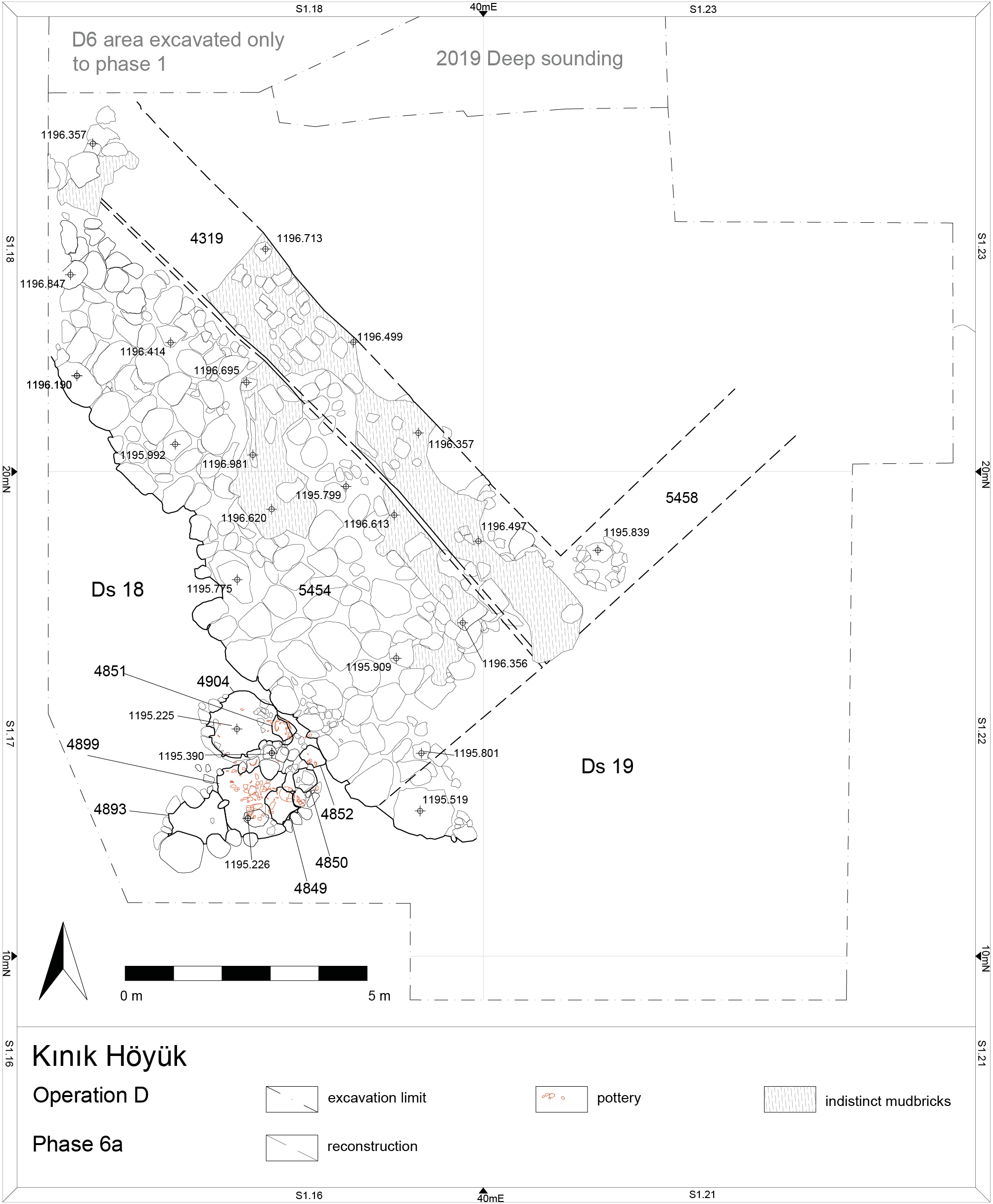
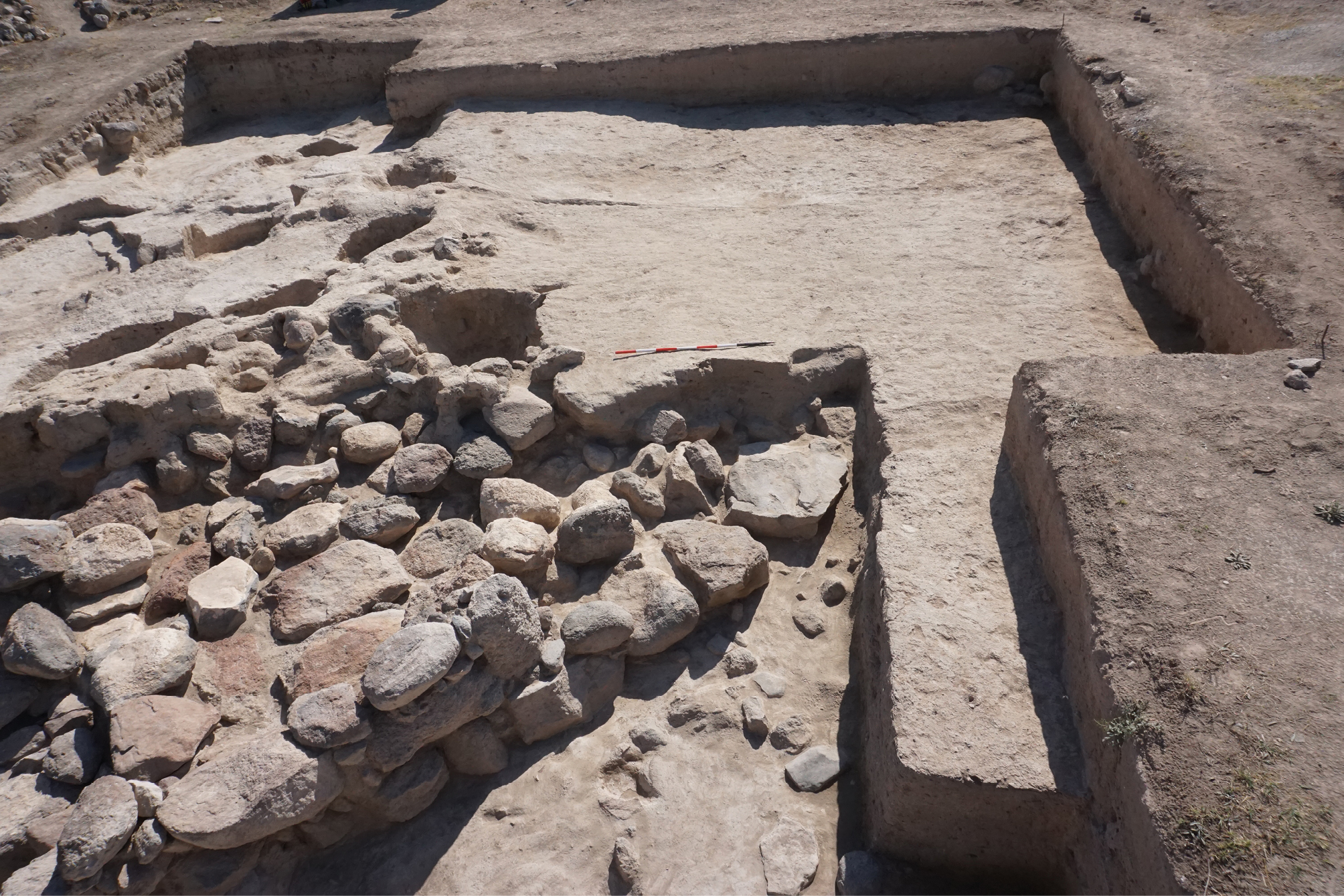
To the east of fortification wall D5454, mudbrick wall D4319 was identified, running parallel to it and in large part abutting its line. While D5454 is built with a massive stone socle, D5416 is entirely constructed of mudbrick, with foundations sunk into the ground and composed of small to medium-sized stones (Fig. 5). Its elevation consists exclusively of mudbrick, and the wall appears to abut the fortification wall, suggesting that it was built immediately afterwards, although certainly in use contemporaneously. Wall D4319 has a thickness of about 1.7 m and follows the same NW–SE orientation, parallel to the fortification wall.
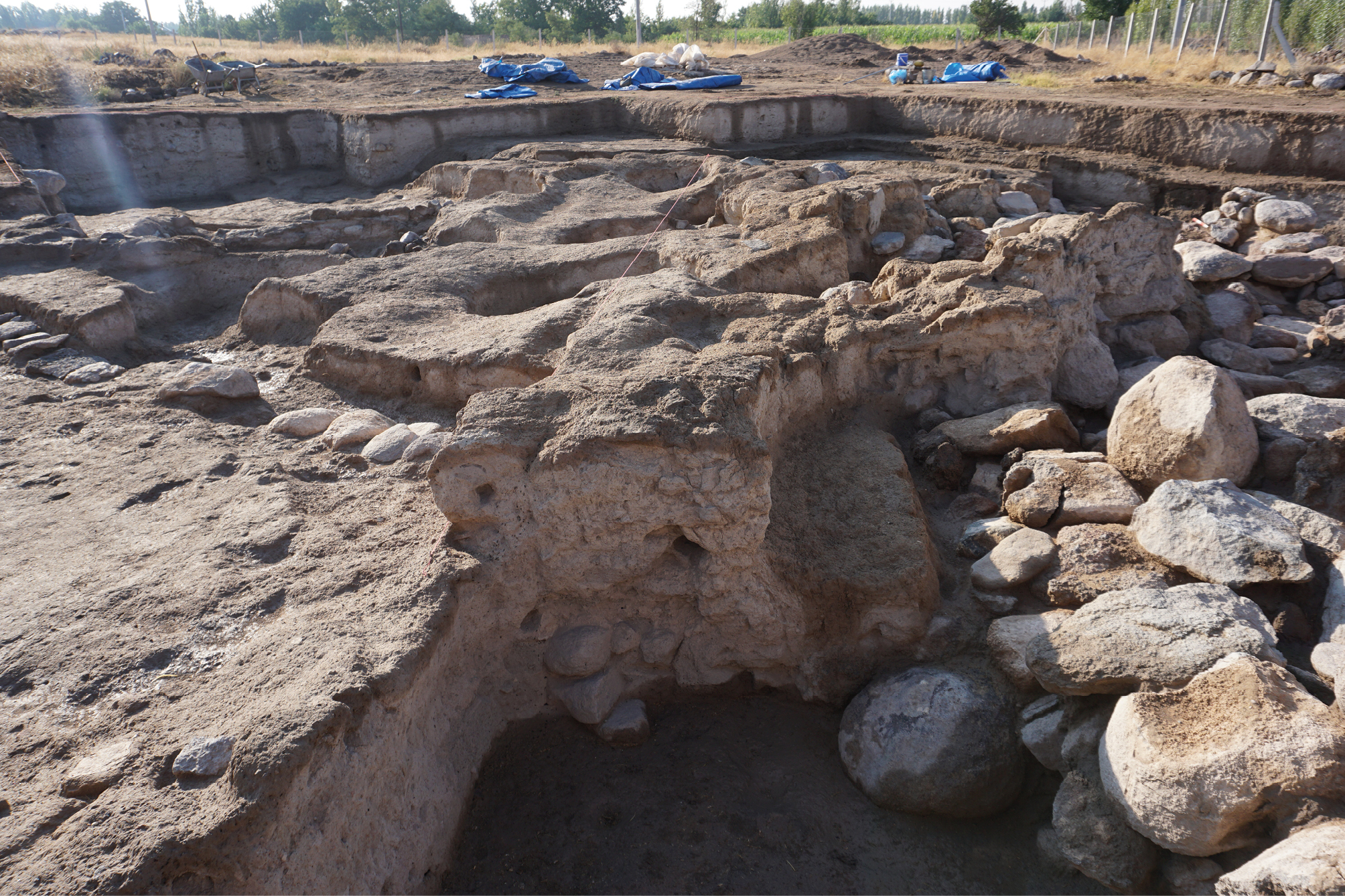
Towards the north, both wall D4319 and wall D5454 continue beyond the present excavation limit in the direction of NNE. At its southern end, however, in correspondence with the tower of the fortification wall, wall D4319 forms a corner and shifts to a NE-SW alignment, thereby creating an angle and connecting with a second wall unit (D5458). Together, walls D4319 and D5458 form a structural junction that most likely constituted the corner of a building located inside the Lower Town, directly adjacent to the fortification wall. The joint between the two masonry units is visible only in the section of a pit located in the NW portion of the trench (Fig. 5). The interior of this building, most likely delimited by walls D4319 and D5458, has not yet been investigated in relation to its Phase 6 occupation: in this area, excavations have so far reached only the contexts immediately preceding the Phase 4 occupation, and thus the Phase 6 deposits remain to be explored in forthcoming campaigns. Nevertheless, MBA occupation levels associated with this building are certainly present, as the cuts of Phase 3 pits have penetrated down to the base of the wall, clearly demonstrating earlier levels visible in section and on pit bottoms.
Outside the settlement, numerous fire installations were identified abutting from the SW the fortification wall D5454, and indicating activities that took place outside the limits of the town itself. A total of seven fire installations has so far been clearly identified in this sector, all of them large hearths. These can be distinguished into two groups that most likely succeeded one another in different phases of use. The earlier and original phase comprises three large installations – D4904 (filling D4903), D4899 (filling D4900), and D4893 (filling D4894). These hearths were set into the floor and delimited by medium- to large-sized stones forming their perimeter. In some cases, such as installation D4904, mudbricks were also used to delimit the hearth. The second group consists of smaller hearths – D4851, D4849 (fillings D4862, D4863, D4865), D4850, and D4852 – which share the same basic construction technique of stone perimeters but differ in scale and placement. These later hearths are slightly higher than the large installations and, in several cases, are positioned alongside them, while in others – such as D4849 – they were built directly within the earlier large hearths (Fig. 3). All installations were found filled with ceramic fragments and characterised by deposits rich in ash and charcoal, with additional material preserved inside the vessels or, more frequently, among the sherds scattered within them. The most intense concentrations of burning – abundant charcoal, charred seeds, and other combustion debris – were not found at the centre of the large hearths but rather in the smaller ones alongside them. This pattern suggests that, within the larger installations, distinct activity zones were created, with the smaller hearths serving as the primary loci of fire and cooking, while adjacent areas within the same complexes were likely used for different kinds of work. Such evidence points to a functional organisation of the activity area, in which cooking, preparation, and associated tasks were spatially articulated around the hearth complexes.
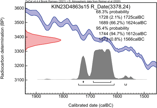
A radiocarbon analysis was conducted on three wheat grains (lab. no. TÜBİTAK 3740; sample code KIN23D4863s15) recovered from D4863, associated with Phase 6 contexts. The measurement yielded a calibrated date range (2σ) of 1744–1612 BC (94.7%) and 1573–1566 BC (0.8%), situating the sample securely within the MBA and confirming the attribution of Phase 6 to this period (cf. Table 2; Fig. 6).
| Lab. No. | Sample Code | Material | Method | BP Age (±1σ) |
Calibrated Age (2σ) | Context (SU) |
|---|---|---|---|---|---|---|
| TÜBİTAK3740 | KIN23D4863S15 | Triticum sp. (3 grains) | Acid-Base- Acid | 3378 ±24 BP | 1573–1566 BC (0.8%) | SU D4863 (Phase 6) |
The deposit (D4829) covering all these installations was characterised by large amounts of ash and small charcoal fragments. A particularly significant indicator that the installations – although constructed at different moments – were probably used simultaneously is the presence of complete, well-preserved vessels found even within the larger (and thus lower) hearths. This suggests that the entire activity area was abandoned abruptly leaving a “frozen” occupational surface that captures the final phase of use. In particular, installations such as D4851, located close to the fortification wall yet respecting its alignment, display clear traces of burning and use on the inner face of the wall.
The presentation of the Phase 6 evidence concerns primarily its final stage of use, represented by the hearth installations, here designated Phase 6a. In addition, a sub-phase 6b has been created for analytical purposes, since it remains uncertain whether the fortification wall pre-dated the construction of the fire installations; excavation has not yet reached the levels beneath them. This subdivision is therefore operational and methodological rather than founded on demonstrated stratigraphic relationships.
4b. Zooarchaeology
The MBA faunal assemblage is relatively small but displays a clear reliance on domestic livestock (Table 3). Cattle and caprines (sheep-goat) dominate the taxonomic profile, with minor contributions from pigs. Fish appears in trace amounts. Overall fragmentation is moderate, and the majority derives from sheep-sized mammals, consistent with everyday food processing and discard.
| Taxa | NISP | %NISP | Weight(g) | %Weight |
|---|---|---|---|---|
| Mammal (cattle-size) | 14 | 16.28 | 140 | 23.20 |
| Mammal (sheep-size) | 43 | 50.00 | 119 | 19.72 |
| Mammal (indet.) | 1 | 1.16 | 1 | 0.17 |
| Bos taurus – cattle | 6 | 6.98 | 157 | 26.01 |
| Ovis aries – sheep | 4 | 4.65 | 39 | 6.46 |
| Capra hircus – goat | 1 | 1.16 | 13 | 2.15 |
| Caprine – sheep/goat | 11 | 12.79 | 101 | 16.74 |
| Sus domesticus – pig | 4 | 4.65 | 29.5 | 4.89 |
| Cyprinidae – carp-like fish | 1 | 1.16 | 0.02 | 0.00 |
| Homo – human | 1 | 1.16 | 4 | 0.66 |
| Total | 86 | 100 | 603.52 | 100 |
The presence of both adult and infant/foetal caprine and pig bones indicates that herding and parturition occurred on or near the site, suggesting local management of small stock. A single human metatarsal recovered among the faunal fragments likely relates to disturbances of nearby graves, which is a recurring pattern in several MBA contexts.
Butchery marks occur on both cattle and caprine bones and include slicing, chopping, and occasional bash marks associated with marrow extraction or disarticulation. Several bones exhibit light to moderate burning, mostly on caprine elements, reflecting cooking or disposal into fireplaces.
Carnivore gnawing is common on pig and cattle bones; in one case, gnawing marks on a pig atlas were likely produced by a cat. Rodent gnawing was also identified on a caprine tibia. Weathering is minimal, limited primarily to cattle astragalus. These taphonomic patterns collectively indicate domestic refuse exposed for short periods before final deposition.
The identification of neonatal and foetal caprine bones, an infant sheep humerus, and juvenile pig elements demonstrates that young animals formed part of both the herded population and the consumed assemblage. Consumption of very young individuals, especially goats and pigs, suggests opportunistic slaughter or utilization of perinatal mortality.
The faunal assemblage from Phase 6 includes at least two noteworthy bone items. One of these is a spindle whorl (KIN23D4900s71), made from cattle femoral head, showing clear use-wear around its perforation, indicating that it functioned as a textile tool prior to discard. Another item is a small polished spatula-like implement (KIN23D4890s63), probably a simple bone tool. These artefacts confirm that domestic craft activities, such as spinning, were taking place alongside food-processing routines.
Taken together, the faunal remains indicate typical household waste, comprising butchery debris, food-related refuse, and occasional small tools. The mixture of domestic species, routine processing marks, and evidence for on-site animal birthing reflects a small-scale mixed agro-pastoral economy. The depositional history of the assemblage, characterised by burning, gnawing, and sporadic human bone intrusions, suggests gradual accumulation within domestic or semi-domestic spaces, possibly influenced by activities near burial areas.
4c) Paleoethnobotany7
Paleoethnobotanical analyses were conducted on four flotation samples from Phase 6, originating from primary deposits associated with fireplaces (KIN22D4829s24; KIN22D4847s51; KIN23D4863s15) and from the fill of a jar (KIN22D4846s48) (Table 9, available online in supplementary material). The concentration of botanical macro-remains is particularly low, consisting only of discrete quantities of charcoal fragments larger than 2 mm (0.03 g/L) and a total of 12 seeds. This paucity may reflect recurrent cleaning of the pyrotechnic installations of Phase 6, with the associated dump deposits yet to be identified and excavated. Post-depositional processes affecting the preservation of charred plant materials can reasonably be ruled out, given the presence of richer archaeobotanical assemblages elsewhere in the Lower Town of Kınık Höyük (Castellano 2021, Castellano 2022).
The wood charcoal assemblage is restricted to two taxa: deciduous oak (Quercus sp. deciduous; 33 fragments) and willow/poplar (Salicaceae; 16 fragments). As discussed elsewhere (Castellano 2021), oaks represented the main fuel resource exploited at the site throughout the first millennium BC, likely collected from the slopes of the mountains north of the site (Hasan Dağı, Keçiboyduran Dağı, and Melendiz Dağı). Although provisional, the Phase 6 evidence suggests that oaks were also extensively exploited for firewood in the MBA. Willow and poplar, in contrast, are associated with riparian vegetation, likely growing in the wet environments of the surrounding floodplain (Castellano et al. 2023).
Carpological remains are limited to single finds. Hulled barley (Hordeum vulgare) is the only cultivated taxon represented (five grains; KIN23D4863s15). Non-economic taxa include common field weeds, such as Vaccaria pyramidata (KIN22D4829s24), Salsola sp. (KIN22D4829s24), Medicago-type (KIN22D4846s48), Trigonella-type (KIN22D4846s48), Asperula sp. (KIN22D4846s48), and Galium sp. (KIN22D4846s48). The very low density of carpological finds suggests that dung burning played only a minor role in the formation of these assemblages.
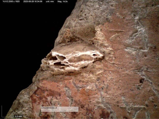
A discrete quantity of amorphous charred material (0.126 g) was recovered from sample KIN23D4863s15. This substance consists of vitrified clots with large voids and occasional linear impressions on one surface. Pending a dedicated study, requiring observation under an electron microscope (SEM), it may be hypothesized that this material derived from a melted, unidentified substance, related to pretechnological activities conducted in this area during Phase 6.
4d. The in-situ pottery assemblage from Phase 6
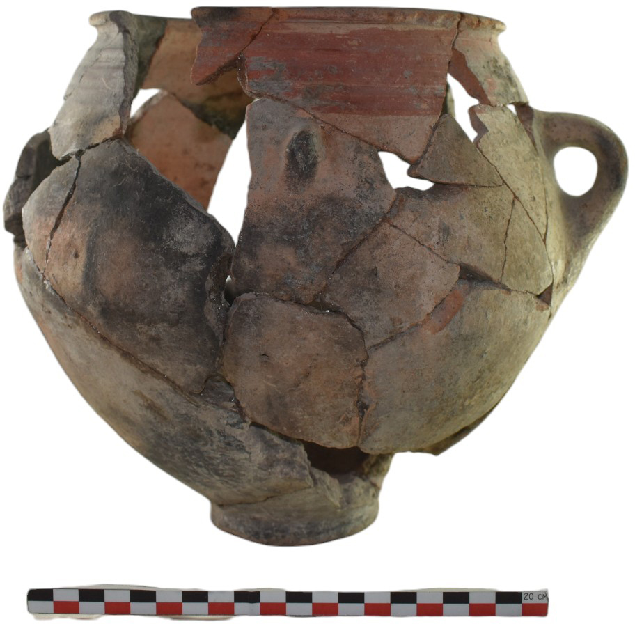
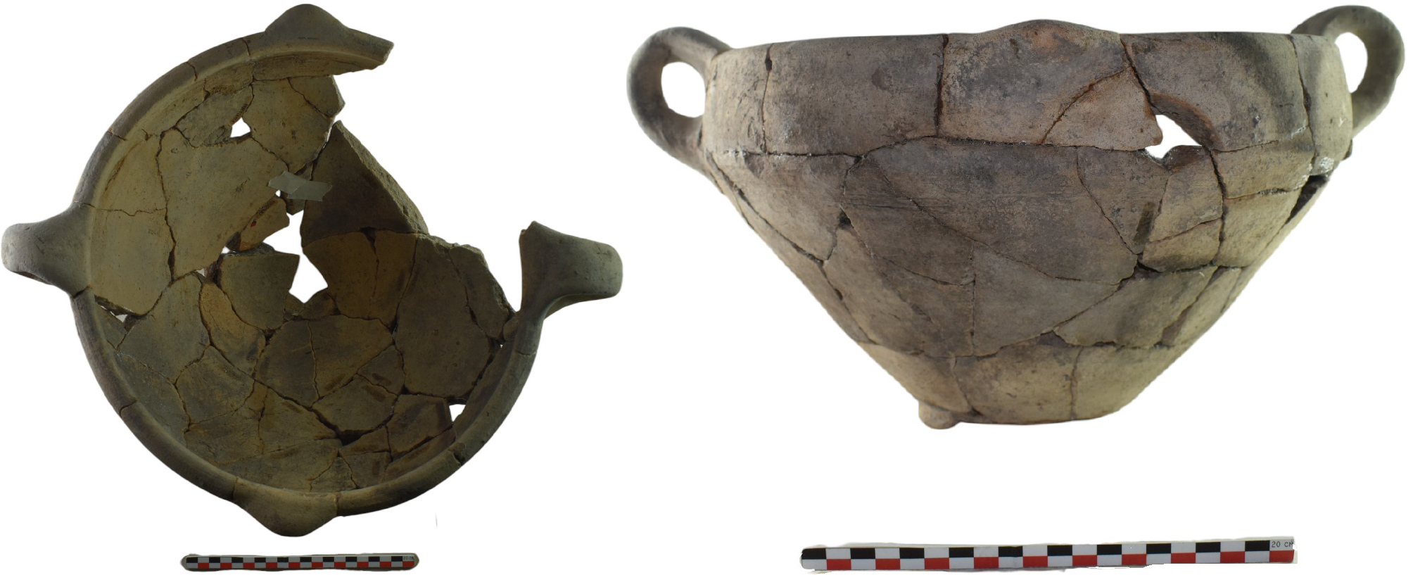
The Phase 6 ceramic assemblage discussed here derives from five fire installations8 identified outside the walls of the Lower Town. Approximately twenty complete vessels were found in situ within the features; together with those recovered from the deposits covering them, the assemblage comprises around ninety items in total. This paper presents c. 25% of the inventory, focusing on the complete vessels, in order to provide an overview of the in-situ assemblage and its most representative items (Figs 7-9).
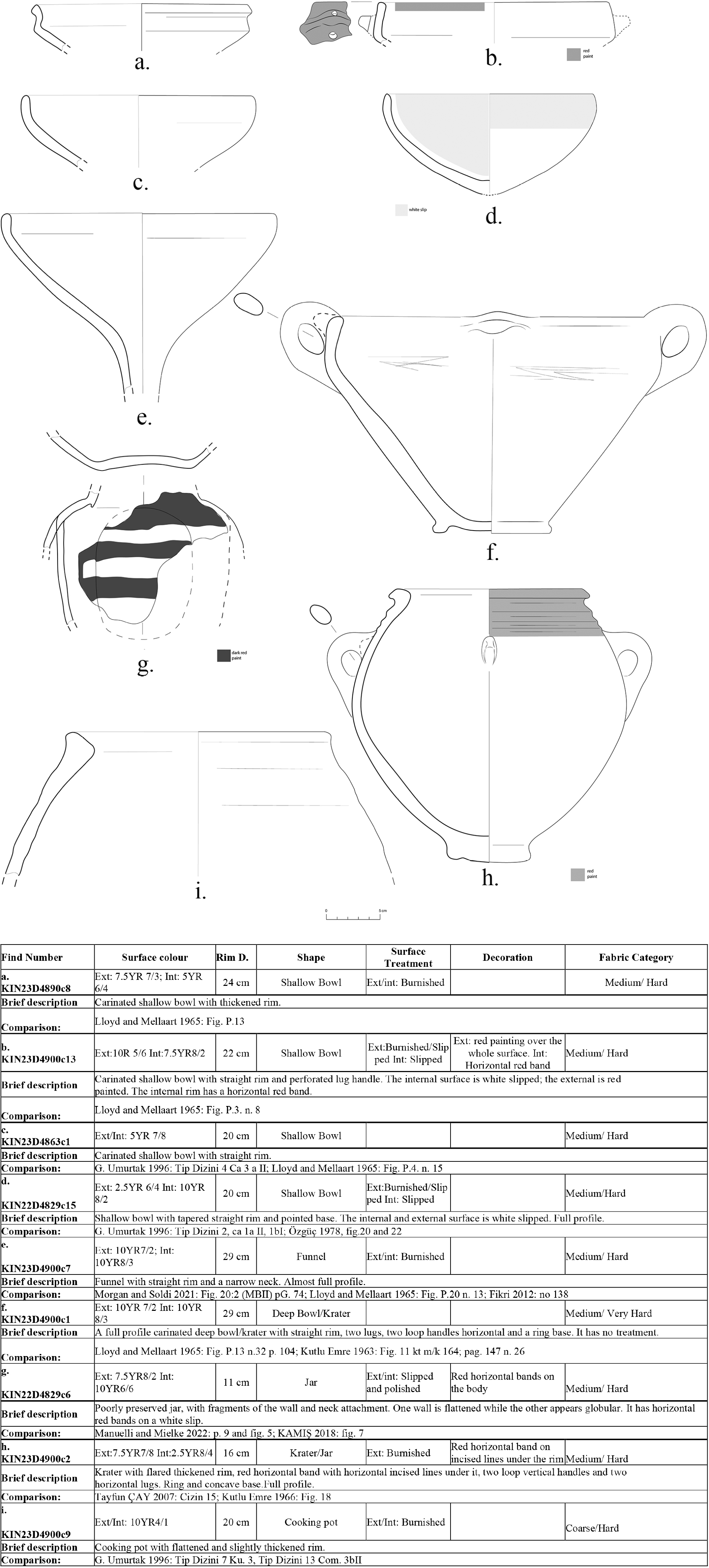
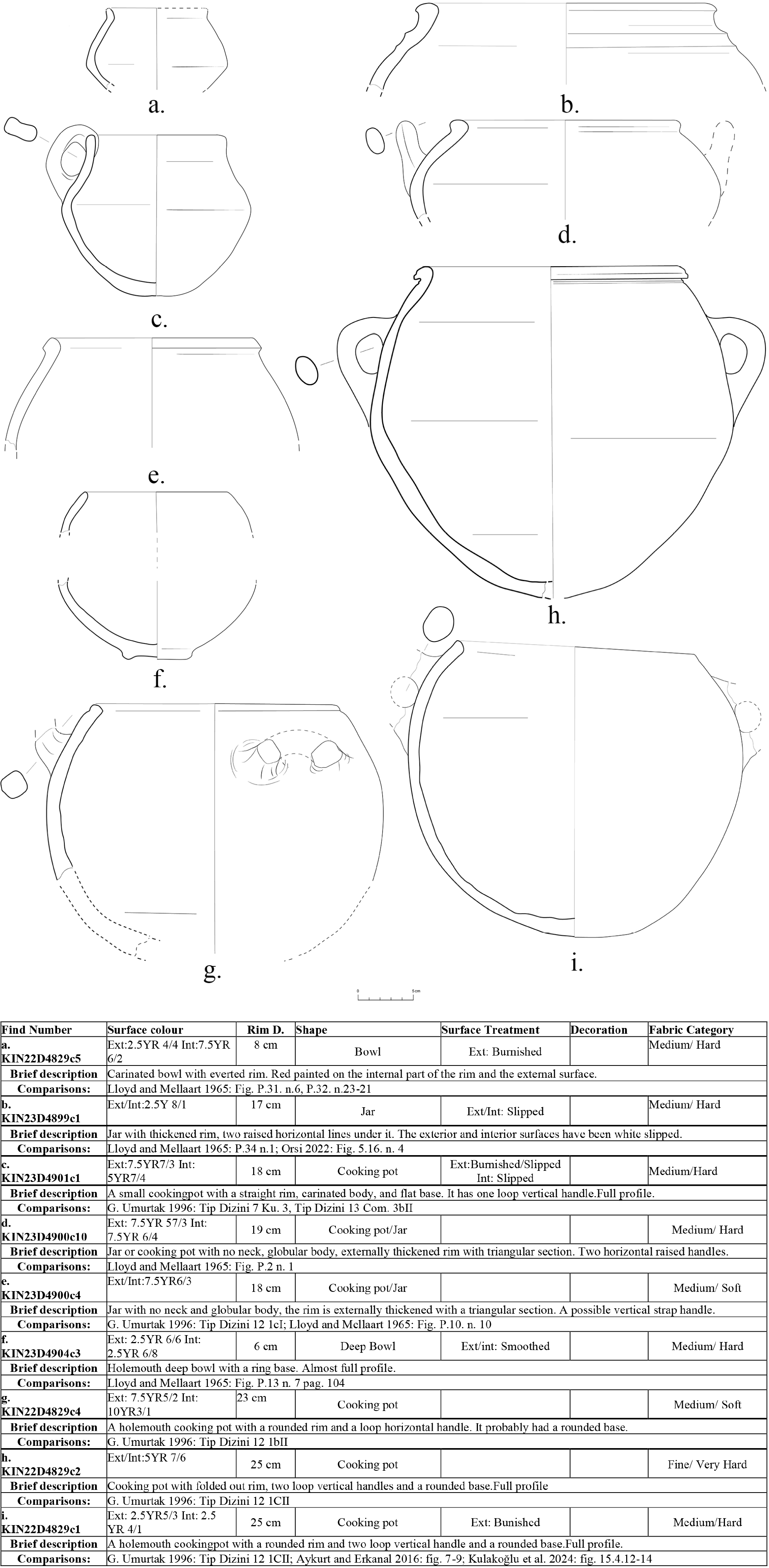
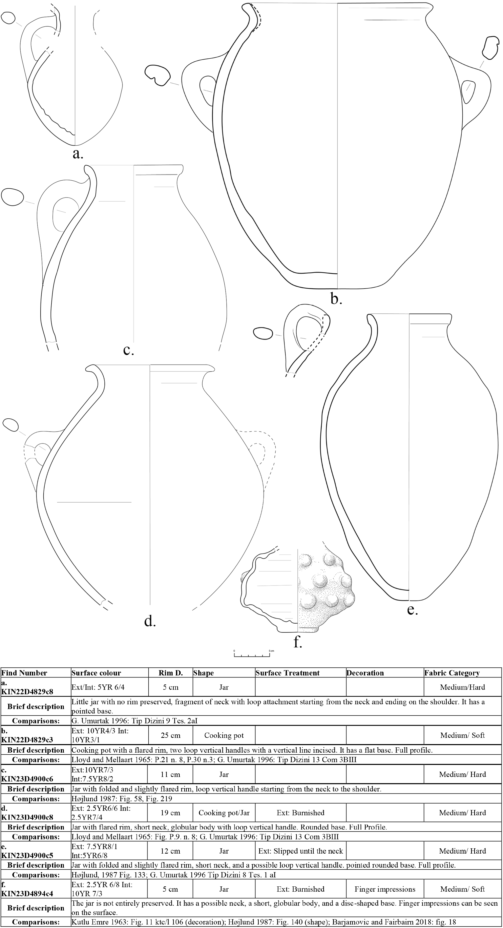
Among the vessel types identified, cooking pots are particularly well represented (12), underlining the importance of food-preparation activities. Jars (13) appear frequently as well, most likely serving for short-term storage of foodstuffs and liquids. Bowls, though less numerous, indicate vessels suitable for individual or collective consumption, while kraters point to practices of mixing or serving larger quantities of food and drink. Together, these shapes illustrate a functional repertoire consistent with activities expected in association with open-air fire installations situated beyond the defensive walls of the settlement.
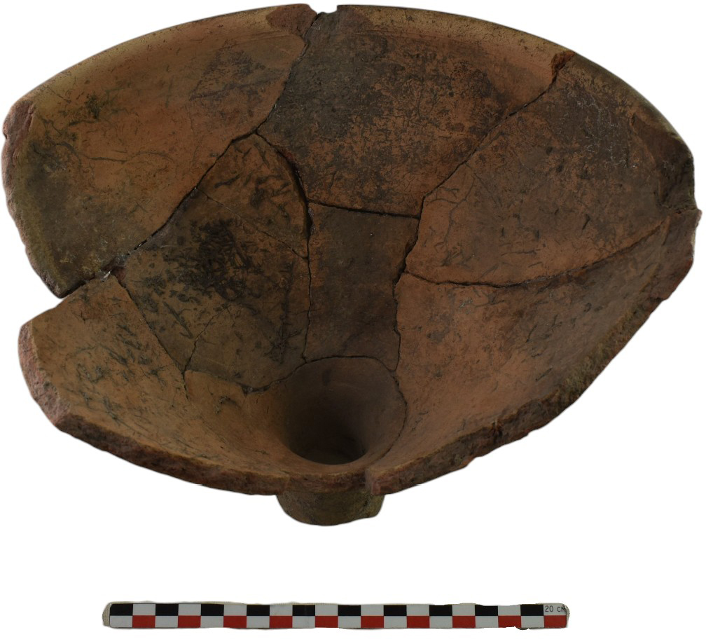
Bowls. Two main types predominate: (1) hemispherical bowls with a tapered straight rim and pointed base (e.g., KIN22D4829c15; Fig. 7a), and (2) carinated shallow bowls with a thickened rim (KIN23D4890c8; Fig.7b). Both show a slip or wash; the carinated example has exterior wheel-burnish. Hemispherical bowls are well represented in MBA assemblages at Acemhöyük, Level III (Emre 1966: figs 66, 68). Comparable bowls are also known from Beycesultan (Mellaart, Lloyd 1965: fig. P.13), Korucutepe (Umurtak 1996: type 2, ca 1a II, 1b I) and Kazankaya (Özgüç 1978: figs 20, 22). In addition, a single funnel is represented (KIN23D4900c7; Fig. 7c and Fig.14), characterised by a straight rim and narrow spout; the upper part mirrors the profile of a hemispherical bowl with straight rim. Comparable, though not identical, examples have been identified at Zincirli, with comparisons to Tarsus (Morgan, Soldi 2021: fig. 20:22, MB II), Beycesultan (Mellaart, Lloyd 1965: fig. p.20 no 13) and Kaniš (Kulakoğlu, Kangal 2012: no 138).
Cooking pots. Two size-groups are present in the assemblage: small cooking pots (c. 1.5 l) and very large ones (c. 10 l). The small pots include squat biconical forms with outcurving rim (Fig. 8a, c, d), as well as spherical hole-mouth forms. Most large examples are hole-mouth vessels with rounded rim, two vertical loop handles, a rounded base, and a globular body (KIN22D4829c1; Fig. 8g–i). Another recurrent variant consists of cooking pots with a folded-out rim, two vertical loop handles, a rounded base, and a more elongated body (KIN22D4829c3; Fig. 9b). Parallels can be drawn with material from Beycesultan (Mellaart and Lloyd 1965: pl.21 no. 28; pl.30 no. 23) and Korucutepe (Umurtak 1996: type 12 11C II, type 13, 13B III), Limantepe (Aykurt and Erkanal 2016: figs 7–9), and 18th century BC cooking wares from Kaniš (Kulakoğlu et al. 2024: figs 15.14.12–14).
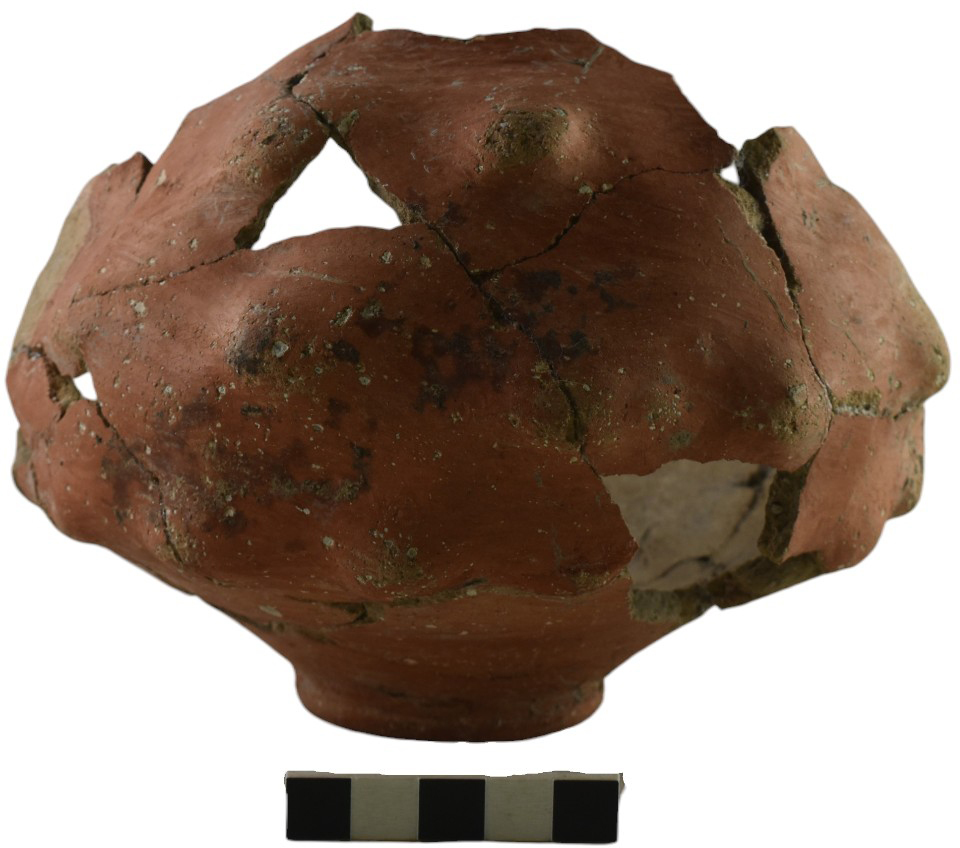
Jars. The large jars (Fig. 9c, e, f) exhibit either a flared rim with short neck and globular body (KIN23D4900c8), similar to examples from Beycesultan and Korucutepe (Lloyd and Mellaart 1965: fig. p.9 no 8; Umurtak 1996: type 13 Com 3B III), or a folded, slightly flared rim with short neck, a possible vertical loop handle, and a pointed-rounded base (KIN23D4900c5, Fig.9f), with parallels from Korucutepe (Umurtak 1996: type 8 Tes. 1a I). Among the small jars, one example has a globular body, pointed base, and vertical handle (KIN22D4829c8), broadly comparable with jug bodies from Kaniš (Emre 1963: fig. 47) and Korucutepe (Umurtak 1996: type 9, 2a I). A second small jar has a squat spherical body; its surface displays finger impressions created by pressing the vessel wall from the inside outwards (KIN23D4894c4, Fig.10n). This “grape-cluster” effect is known in MBA Anatolia at Kaniš (Emre 1963: fig. 11 ktc/l 106) and Konya-Karahöyük (Barjamovic and Fairbairn 2018: fig. 18).
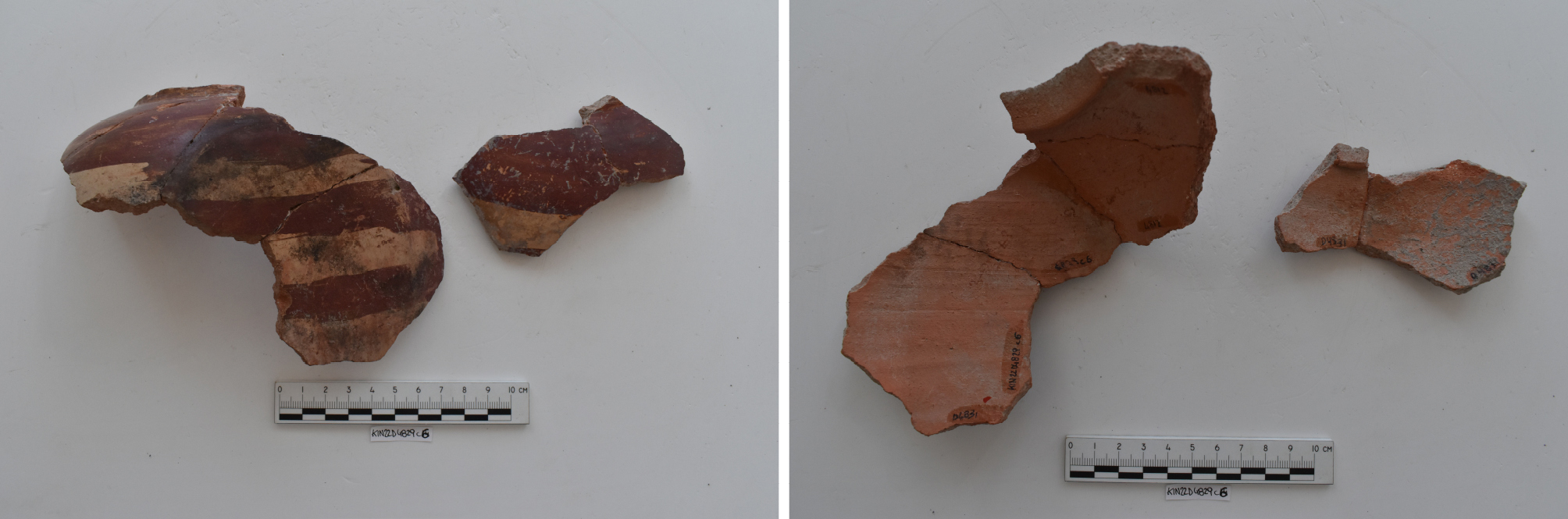
A squared bottle/jar (KIN22D4829c6, Fig. 11), poorly preserved, surviving only in wall fragments and the neck junction also belongs to “specialty containers”. The vessel is wheel-made, with the body subsequently modified by pressing one wall with a rounded tool to create a squared appearance: one side is flattened, the opposite remains globular. Broad red bands are painted over a white slip after the body reshaping, indicating intentional modification. The decoration – broad red bands on a lighter background – appears to belong to the MBA “band-decorated” tradition, widely attested at Kültepe, Alişar Höyük, and Maşat Höyük (Manuelli and Mielke 2022: 9, fig. 5), as well as at Acemhöyük (Kamış 2018: fig. 7). The squared bottle under examination has no exact parallels in currently known MBA repertoires; a possible comparison is a rectangular-section bottle from Kaniš, although its manufacturing technique (wheel-thrown and later reshaped vs entirely handmade) remains uncertain. Despite the rarity of such forms, this specimen – together with the grape-shaped vessel – fits the broader eclecticism that characterises MBA II ceramic production, well attested at Acemhöyük and Kaniš, where conventional forms co-existed with unusual, innovative shapes.
Kraters. Two kraters were identified, differing morphologically. The first is a biconical pot with flared, thickened rim, two vertical loop handles, possibly two lugs, and a concave base (KIN23D4900c2 Fig. 12); the rim bears a red horizontal band and incised lines. Parallels may be drawn with material from Köy Kalesi (Üyümez et al. 2007: fig. 15) and Acemhöyük (Emre 1966: fig. 18). The second specimen is a complete carinated deep bowl/krater with straight rim, two lugs, two horizontal loop handles, and a ring base, without surface treatment (KIN23D4900c1, Fig.13). Analogues are documented at Beycesultan, Acemhöyük, and Kültepe (Lloyd and Mellaart 1965: fig. P.13 no. 32, p. 104; Emre 1966: fig. 11 kt m/k 164, p. 147). Overall, the repertoire shows a preference for globular or elongated vessel shapes, most often with rounded bases.
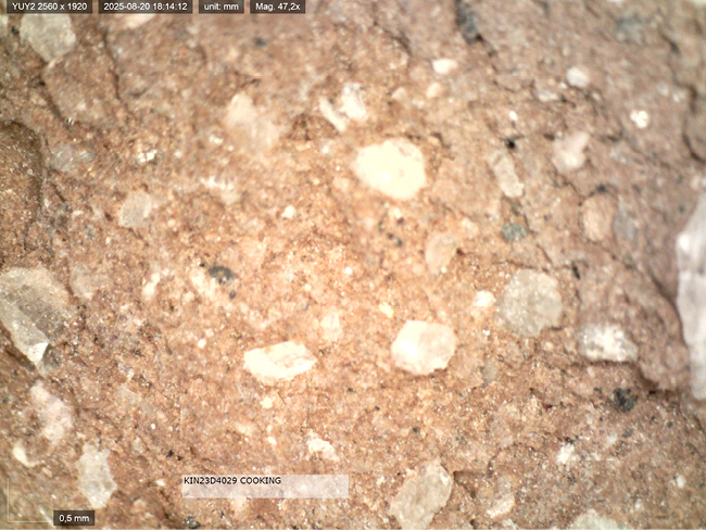
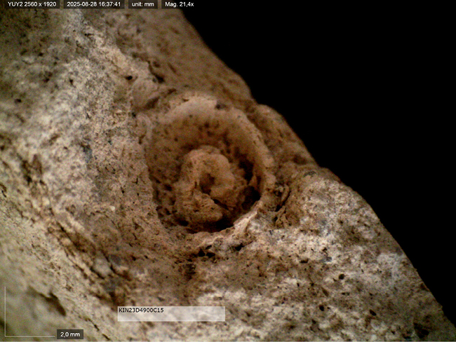
Fabrics and surface treatment. Fine, grit free wares are almost entirely absent. Two main groups can be distinguished: (1) very coarse, dark fabrics used for cooking pots, heavily tempered with mica and small stone inclusions (Fig. 15); and (2) an orange fabric containing stone particles and, in some cases, shell or bone fragments (e.g., Figs 16-17). Slipped and burnished finishes predominate, while decoration is scarce. Only a few vessels bear simple motifs, consisting primarily of red- painted horizontal bands or, more rarely, shallow grooves placed just below the rim (e.g., KIN23D4900c2 Fig. 7h). As for production techniques, most vessels appear to be wheel-thrown; in one exceptional case (KIN22D4829c3 Fig. 9b), the combination of coiling and wheel-finishing is suggested by the absence of regular wheel marks and by an uneven surface texture indicative of hand-building subsequently adjusted on the wheel.
5. From the Middle Bronze Age to the Middle Iron Age (Phase 5)
5a. Stratigraphy
Phase 5 corresponds to the Late Bronze Age (LBA) and has been identified in the excavation area mainly in the SW sector, outside the MBA fortification wall. Few stratigraphic units attributable to this phase have so far been found inside the town, largely because excavations there have rarely extended below Phase 4.
Within the town, at the few points investigated beneath Phase 4, Phase 5 appears as a sterile accumulation almost devoid of cultural material, marking a hiatus in occupation between Phase 6 and Phase 4. Only a few stratigraphic units can be assigned to Phase 5 here, in contrast to the clearer evidence documented outside the town. These consist of poor deposits located beneath the architectural remains of Phase 4, notably stratigraphic unit D5259 in the northern part of the trench. Since the excavation strategy was primarily aimed at tracing the course of the MBA fortification and identifying a possible gate of the same period – prior to investigating the associated levels inside the structure – no further information is currently available for these deposits. Owing to the limited extent and incomplete investigation of the archaeological deposits pertaining to this phase, no samples are yet available for palaeobotanical or faunal analysis.
In the external area, a destruction layer marking the end of Phase 6 was identified exclusively in correspondence with the hearths. Above it, a sequence of deposits accumulated, deriving partly from the collapse of the outer fortification wall (D5454, D4956, D5417) and partly from subsequent erosion and wash (D4809, D4361), following the natural slope of the ground towards the SW. These deposits, poorer in material than those of Phase 6, consist mainly of fine soil with numerous mudbrick fragments. No architectural remains have been attributed to this phase, which appears to have been only sporadically frequented. Some deposits (D4856, D4890, D4901, D4902, D4905) lie between the destruction deposits of Phase 6 and the reoccupation of Phase 4. They contain material partly derived from underlying MBA contexts, but also ceramic forms absent from the MBA repertoire, plausibly belonging to the long period of abandonment that preceded the Iron Age reoccupation.
It can be assumed that during this period of abandonment and limited occupation, the MBA fortification wall gradually collapsed and deteriorated, leaving a pronounced imprint on the landscape. Over the four to five centuries preceding the Iron Age reoccupation, the decaying wall must have formed a conspicuous feature – an earthen ramp or berm – that continued to mark the original limit of the town. This enduring topographic presence likely influenced the subsequent organisation of the settlement during the Iron Age, acting as a persistent landmark of the earlier urban layout and providing the physical backdrop against which the reoccupation of Phase 4 took place.
5b. Pottery
As the study of the ceramic assemblages from both Phase 6 and Phase 5 is still ongoing – particularly for Phase 5, which presents numerous difficulties due to its non-primary contexts – we present here a preliminary selection of materials from stratigraphic units situated at the juncture between Phase 6 and Phase 4, exclusively from deposits outside the fortification wall. The aim is to offer a general overview, highlighting significant morphological variations that may reflect broader production trends. Although limited, these data help sketch the LBA typological framework at Kınık Höyük, Fig. 18 illustrates a small set attributable to this short-lived, marginal phase of non-occupation.
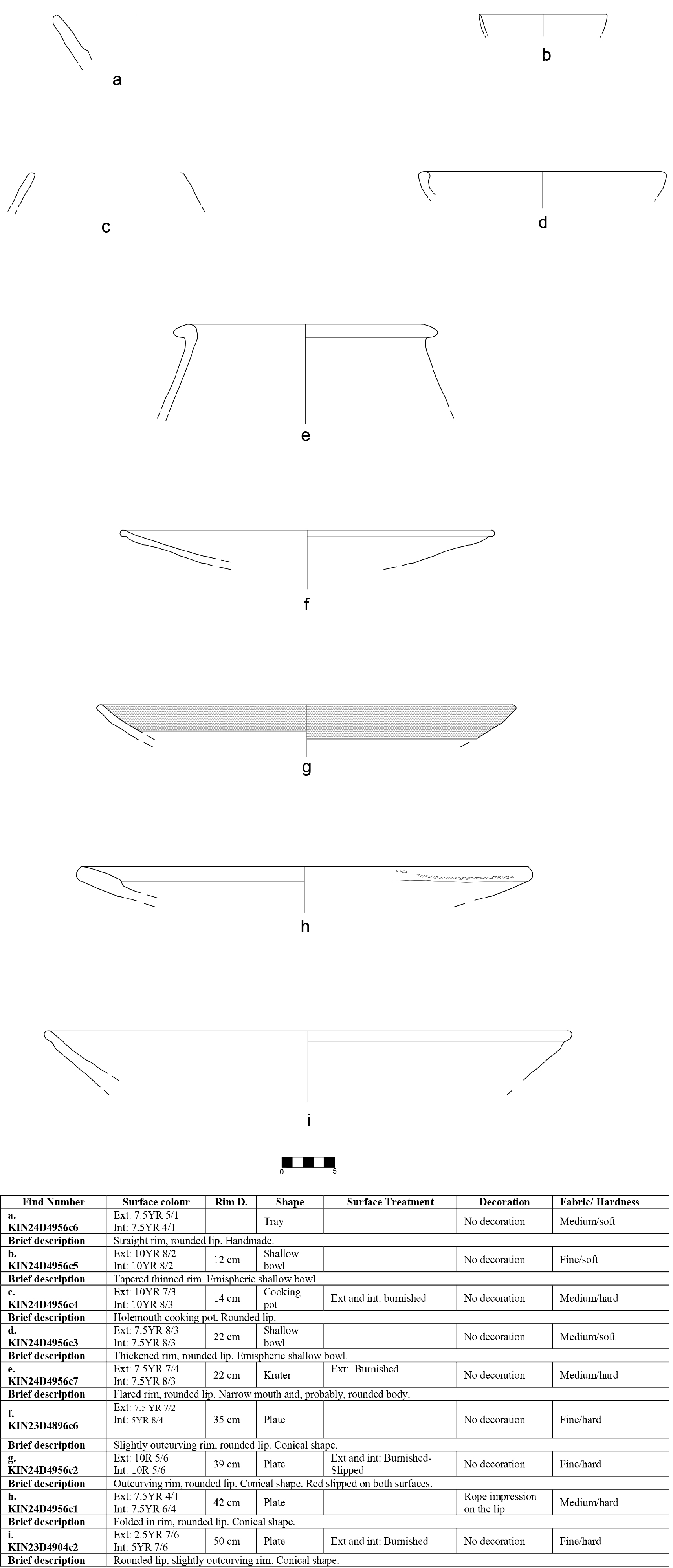
Despite its limited quantitative representation, the transition from Phase 6 to Phase 5 marks an immediate change in the ceramic forms that characterise this phase belonging to the LBA. Notably, open shapes with wide diameters emerge, including true plates (Fig. 18f–h), which have diameters ranging from 35 to 50 cm. These shapes are not present in either the MBA assemblage or the Iron Age ceramic repertoire. Taken together, these features suggest a clear shift in ceramic shapes compared to the preceding period.
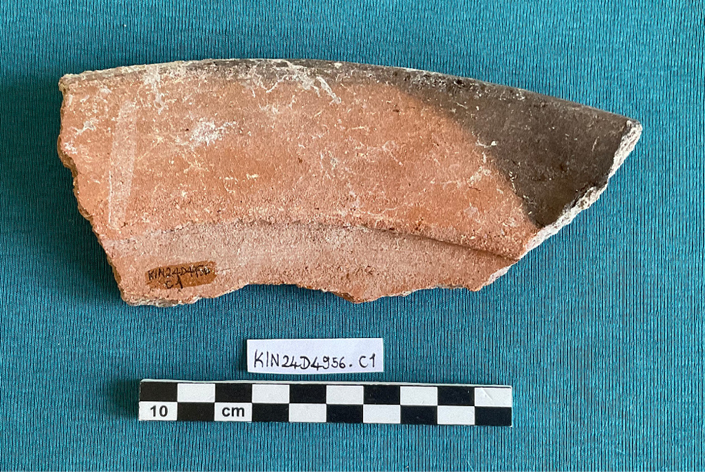
Plates. The most distinctive innovation in the inventory is the appearance of large, very open plates, absent from the primary MBA contexts. In Fig. 18 (nos f–i), the standout specimen is no ih, a circa 42 cm conical plate with an inward-folded (Fig. 19), flattened rim and a cordon-like impression on the outer edge. Its very coarse, reddish fabric recalls cooking ware and aligns with LBA production in Central Anatolia, including Hittite-period assemblages. The plates are characterised by simple or folded rims that create a relatively thickened edge. Only one item (Fig. 18h) has a rope impression on the exterior of the rim, and another has red slip on both surfaces. Nos f–h represent local variants of the same general plate form: conical, with simpler slightly everted rims, thinner walls, and common-ware fabrics. Sizes vary considerably (c. 28–55 cm) (see Müller-Karpe 1988,Pl. 32, nos. 30–42; Pl. 43, no. 5; Mülenbruch 2014, Pl. 29, nos. 5, 10) . The restriction of these plates to Phase 5 marks a clear morphological shift from Phase 6.
Comparable trends – widespread, large serving plates in both “Anatolian” and locally refined fabrics – are documented further south, e.g., at Tell Atchana, and may reflect changing consumption practices. Given the limited dataset and the lack of sustained occupation in this sector, a direct cultural influence from the Hittite core cannot be argued on present evidence (see discussion below).
Bowls. The assemblage includes bowls that continue Phase 6 models (e.g., small hemispherical bowls with slightly tapered rims), together with larger, deeper bowls with thickened incurving rims. These are well attested in Middle and Late Bronze Age productions across Central Anatolia and the northern Levant (Fig. 18a, see Mülenbruch 2014, pl. 25 n. 10. Fig. 18d, see Mülenbruch 2014, pl. 16 n. 10-12).
Cooking pots. Only one cooking-pot fragment (Fig. 18b) is represented here. It departs from MBA prototypes: its more ovoid body profile is less frequently represented in earlier repertoires (cf. Fig. 8i), suggesting formal development rather than strict continuity (see Mülenbruch 2014, pl. 2 n. 32-33).
Krater. No. 18e is a krater with an out-turned rim and a large, globular profile. While the rim follows MBA tradition, the overall morphology is more vertical, implying a large-capacity container; it differs from typical MBA forms, which usually have very wide openings and no distinct neck. The fine, light-coloured fabric and relatively thin walls (for its size) distinguish it from common ware (see Mülenbruch 2014, pl. 10 n. 16; pl. 11 n. 21).
Other forms. Fig. 18a is a classic cooking tray in coarse kitchen fabric; such trays occur in both Middle and Late Bronze Age contexts and are not chronologically diagnostic.
6. The Middle Iron Age reoccupation (Phase 4)
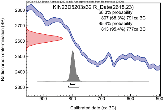
Phase 4 has been divided into three sub-phases, from 4c to 4a, with 4c being the earliest and 4a the most recent, on the basis of minor variations in the urban layout of the phase in this area. It is worth recalling that the terrain in this sector was not originally level and that a difference in elevation must have existed between the inner area of the former MBA town and the external zone, a feature that was still perceptible at the surface. This irregular topography appears to have conditioned the arrangement of the buildings belonging to Phase 4, which adapted to the inherited slope rather than entirely reshaping it. In addition to the marked difference in elevation towards the west and SW, a further drop in level was observed in the southern portion of the area, as if caused by a process of surface wash or erosion affecting this sector. Such irregularities were likely the result of the collapse of the MBA monumental structures, in particular the defensive system, which was no longer visible as standing architecture but continued to shape the exposed topography during Phase 4. In plan, only the most significant layouts are illustrated, namely those of Phase 4c, the earliest, and the subsequent 4b, since the later sub-phase 4a displays only secondary modifications. Ceramic evidence will then be discussed primarily for Phase 4b, in two distinct sectors, the western and the eastern occupation areas. The dating of Phase 4, including all its sub-phases, rests on two main elements: 1) the radiocarbon dating (KIN23D5203s32) recovered from one of the floors attributed to the earliest stage, Phase 4c (see below) (Fig. 26). 2) the complete inventory of finds from Room Dr7, already partly presented in previous publications, which can be attributed to the latest sub-phase of Phase 4. The beginning of Phase 4, corresponding to the reoccupation of this area of the Lower Town, can plausibly be placed around the mid-9th century BC. The end of the occupation, as suggested by the ceramic assemblage and its correlation with the sequence from the acropolis, falls within the full MIA, probably around the mid-8th century BC. Phase 4 therefore spans a period of roughly one century, during which the Lower Town was reoccupied, with new constructions that in part took advantage of the irregularities of the terrain.
6a. Stratigraphy and architecture
Phase 4c: As noted in the introduction to this phase, the reoccupation of this sector of the Lower Town during the Iron Age adapted to and exploited the irregularities of the terrain. It is to be imagined that the collapsed remains of the MBA fortification wall and the adjacent mudbrick structure were still visible as a marked feature, creating a depression in the NE part of the excavation area. Within this depression, a sequence of occupation surfaces has been identified in the northern area.
In its northernmost part, a clay floor associated with several installations was uncovered (Fig. 20). These include two pits (D5279 and D5272) lined with clay and mudbrick fragments, as well as fragments of a basin like installation made of mudbrick (D5302) to the west that appear to have functioned together with the floor surface (D5304). Four small pits filled with pure ashes (D5283) were located in the western area. The floor itself presents particularly distinctive characteristics: in its northern sector – extending at least two additional meters northwards, as attested by the 2019 trench – it shows evidence of burning, visible as a hardened surface (D5287) resulting from prolonged exposure of the underlying deposits to intense heat. The installations in the NW corner appear to relate to a surface that rises slightly, probably over the collapsed remains of the MBA fortification wall. The occupation floors (D5256 and D5304) themselves show, around the burned area and slightly to its exterior – as visible in plan – a series of postholes. Some of these are larger and seem to form a linear alignment, while others are smaller and were probably cut into the surface at different moments (Fig. 25). A close analysis of the two occupational surfaces of this phase (D5256 and D5304) shows that the series of smaller postholes, of reduced diameter, are not consistently present across both superimposed floors, suggesting that the position of these thinner vertical wooden elements was frequently modified over time. By contrast, the four larger postholes, forming a single alignment, are attested in both surfaces.
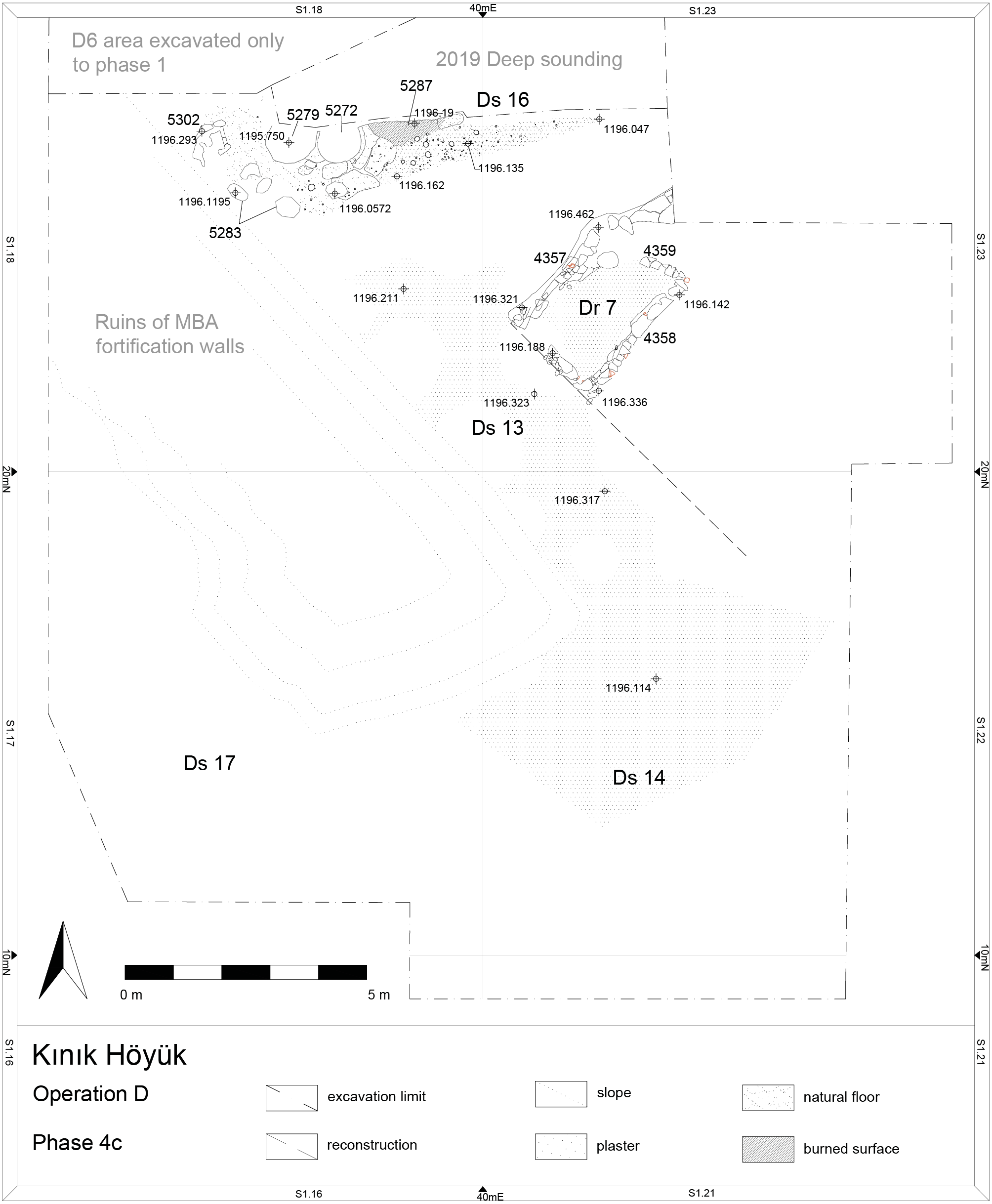
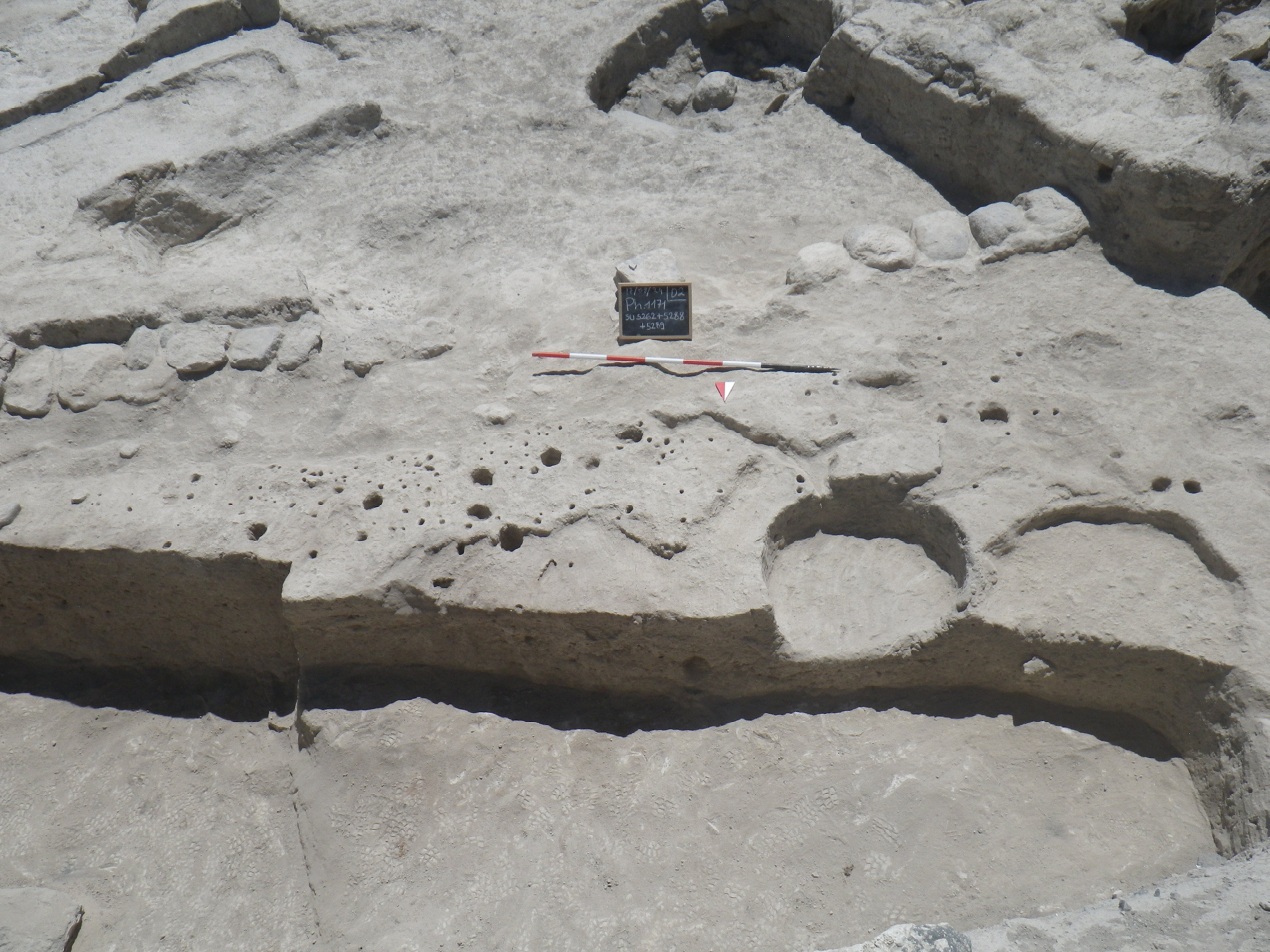
Together, they suggest the presence of a wooden post structure, clearly associated with working activities involving the use of fire or embers, maintained in place for an extended period, and possibly related to craft operations. These floors are no longer preserved further to the south, as is evident in plan, since it was cut by the later installation of a Phase 4b wall, which interrupted its connection with the occupation surfaces located farther south. The contemporaneity of this working surface and its installations with the evidence uncovered farther south – particularly the beaten- earth floor aligned NW-SE is indicated both by their stratigraphic position and by the fact that both were cut by the insertion of the Phase 4b masonry.
In the southern portion of the area (Fig. 21), beyond the ruin of the fortification wall (to the east), a small pathway (Ds13) was already identified in 2021. This feature, oriented NW-SE, consisted of a floor of light limestone plaster. Near the inner façade of the MBA wall (D4319), the surface directly abutted the surviving masonry and in part rested upon the collapsed remains. The pathway descends slightly towards the SE, particularly in correspondence with the ruin of wall D5458, which it entirely overlies, thus compensating for the difference in elevation. In the unbuilt area to the SE (Ds14), several successive occupation surfaces were also recorded, strongly sloping in the same direction and forming a bowl-like depression before rising again toward the southern edge of the excavation. The surface in Ds14 appears to entirely cover the SE end of the MBA wall D4319, overstepping it completely before continuing further down towards the SW corner in Ds17, suggesting that the SE portion of the mudbrick wall (D4319) was no longer visible or functional (cf. Fig. 4).
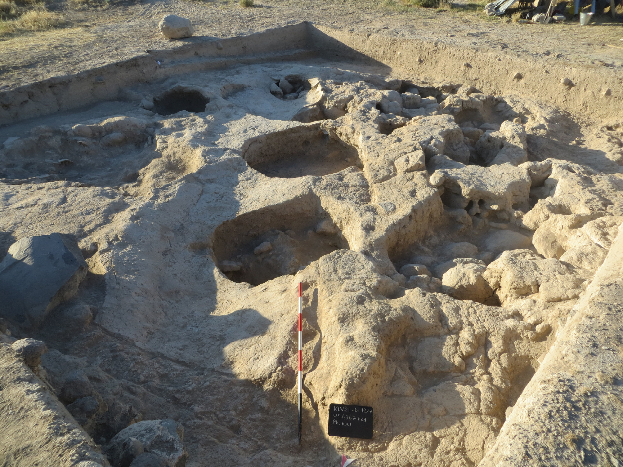
From an interpretative standpoint, this pavement appears to have been adapted to the irregular topography created by the collapse of the MBA structures. In earlier campaigns, the adjacent mudbrick wall was mistakenly attributed to Phase 4, while it is now clear that it belongs to Phase 6. Its well-preserved state at the time, however, suggests that it may have been straightened or regularized during Phase 4, providing a more stable and protective inner surface for the new occupation. The pathway itself, therefore, represents one of the clearest elements of the reorganization of space in this part of the Lower Town, and was most likely functional in connecting different occupation areas established during Phase 4.
The general structure of Room Dr7 (Figs 22-23) was already described in the 2023 preliminary report (Pucci et al. 2023: 108-122). Since then, the dismantling of its walls (DD4357-D4358-D4359-D5252) has provided further information regarding the construction techniques employed. The walls delimiting the room were built of a series of stone slabs, simply placed side by side and set against the cut made into the earlier stratigraphy to insert the room itself. All the floors of the room, both that belonging to Phase 4c and the later ones, were slightly lower than the ruins of the MBA structures and made use of the stumps of these walls, still visible in this area, as a supporting surface. Up to four or five courses of stone slabs, laid adjacently, were recorded. These partition walls did not stand independently but existed only in relation to the cut created for their construction.
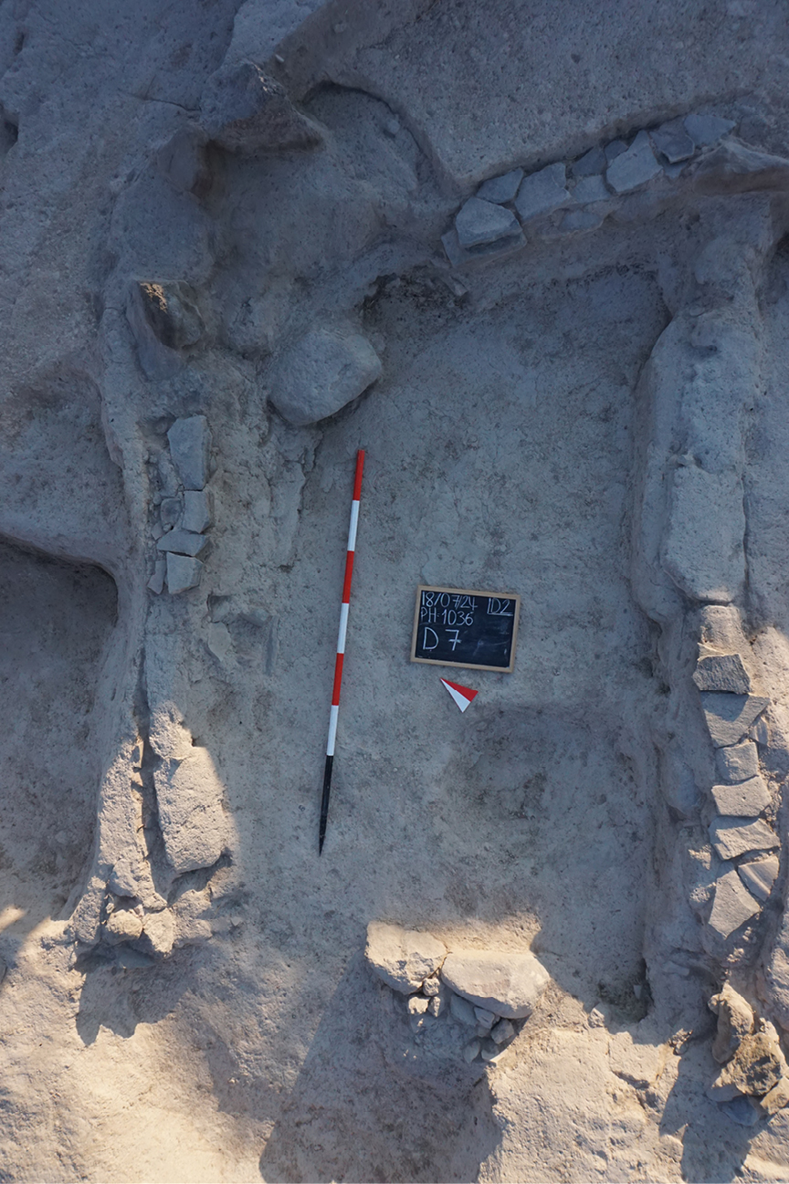
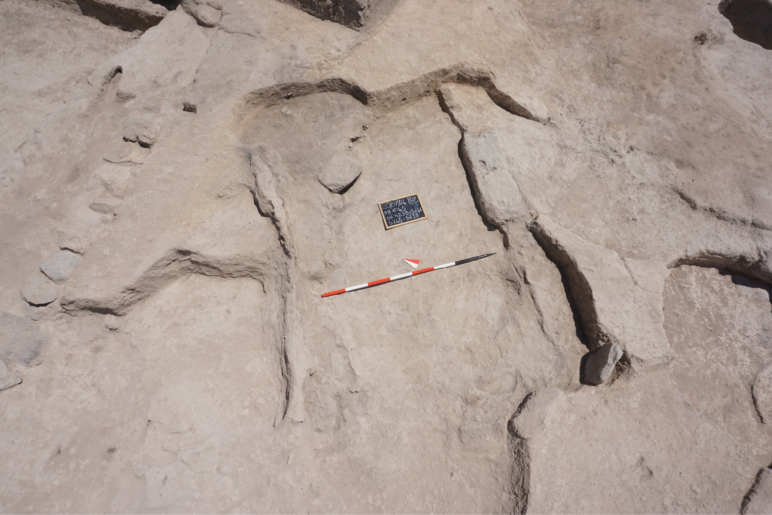
The earliest floors of the room, attributable to Phase 4c, were simple beaten-earth surfaces, frequently renewed during the subsequent sub-phases of Phase 4, with very little material in situ, as the room was apparently cleared, resurfaced, and reused. The original function of the room therefore remains uncertain. The only discernible installation is a slight depression in the SE corner of the room, which, lacking any traces of burning, was probably intended to contain a vessel or a large pithos. Access to the room was possible only through the SE wall, as the other walls are intact and show no doorway. This entrance opened directly onto Street Ds13. A pit – probably of Phase 3 – cut across the area where the doorway would have been, removing the archaeological evidence of the entrance itself. The construction technique and the frequent resurfacing of the floors suggest a primarily utilitarian rather than a representative function for the room.
From an interpretative standpoint, the reoccupation of this sector of the Lower Town during the Iron Age appears to have been of relatively modest architectural quality, characterised by structures that seem to have had a predominantly domestic function. The interpretation of the installations located in the space north of Ds16 remains debated. The presence of a wooden structure set into the floor, associated with a series of pits and evidence of live fire or embers, suggests an open-air area used for specific activities, possibly drying processes or other tasks that required the assembling and dismantling of wooden frameworks. Unfortunately, the finds associated with this phase do not provide further indications as to the exact materials that were being processed in this area.
The transition from sub-phase 4c to 4b, which is also illustrated in plan, is marked by several architectural changes that, however, did not affect Room Dr7, which remained in continuous use throughout the whole of Phase 4.
The architectural changes attested in Phase 4b (Fig. 24) are mainly related, in the northern portion of the excavated sector (Ds16), to the construction of a wall (Fig. 25) with stone foundations and a mudbrick superstructure. This wall was set within a foundation trench that cut through the earlier floors of Space Ds16 (Phase 4c) and the pavement of Street Ds13, and partly truncated the side of the reused mudbrick wall D4319. To the east, the wall continues beneath the section and is no longer visible. Its insertion was not orthogonal to wall D4319, which makes it clear that when this wall was built, the earlier structure was only partially visible, and its alignment was merely followed in an approximate way. The new construction nonetheless served to delimit a well-defined area to the south, where Room Dr7 is located. Within this area, a few small spaces were created (Ds8 and Ds9), containing little material (D4480+D4496). The construction of this new wall was aimed at redefining circulation and functional zones within this part of the Lower Town. As a result, during this phase Space Ds16 was no longer directly connected to Street Ds13, nor did it retain the same functions as in Phase 4c. The sequence of clay floors (D5209, D5203 and D4493 from the most ancient to the most recent) in Space Ds16 clearly show that no wooden structures or pits were installed here. These floors with traces of lime spread across much of the area, abutted the new wall to the south, which makes it clearly contemporary with its use.
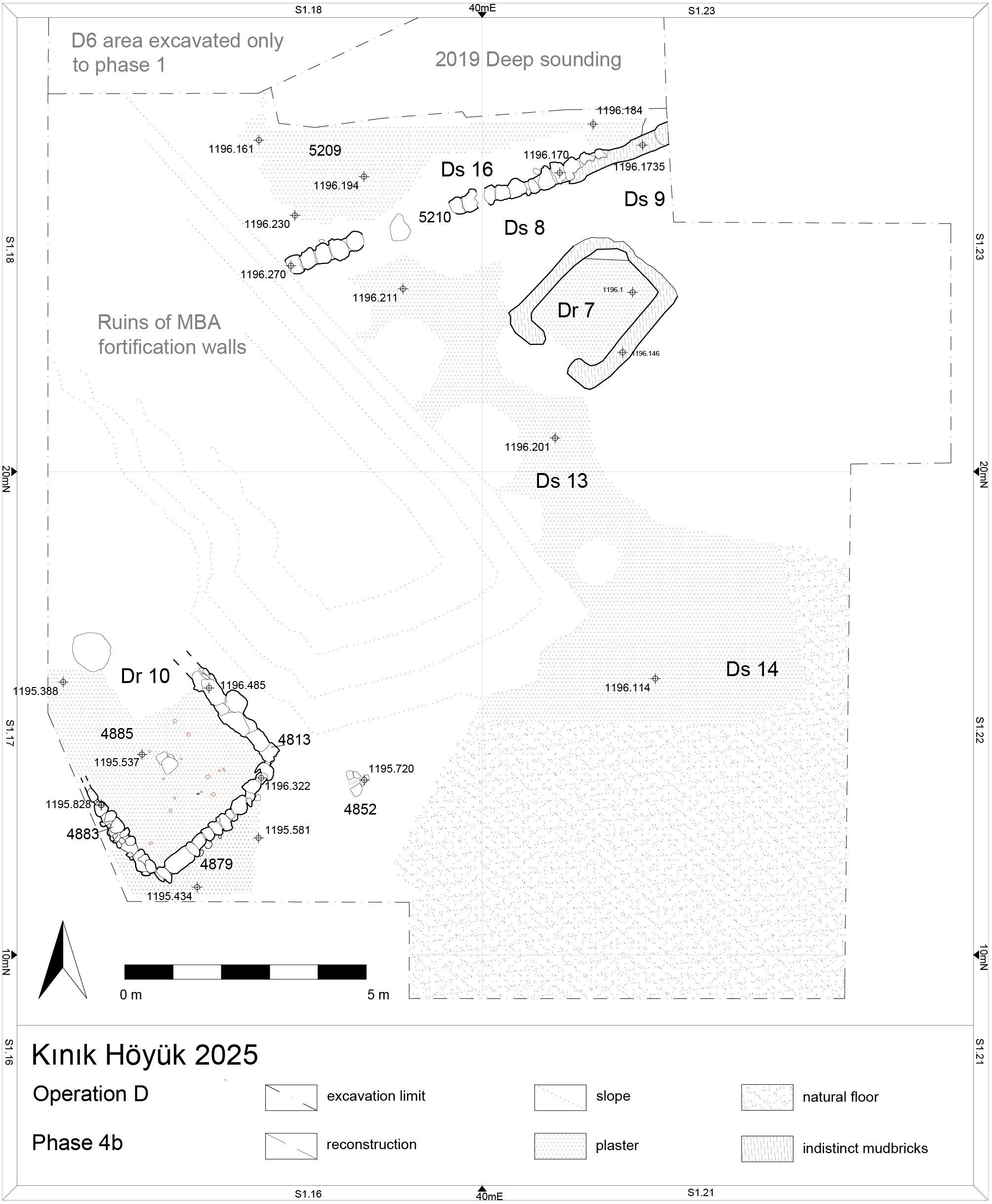
The material recovered from the floors associated with this phase is very scarce and does not provide useful indications for identifying the function of Space Ds10. It is noteworthy that the floor tends to rise slightly towards the surrounding walls – on one side the newly described stone-and- mudbrick wall, and on the other, most likely the partially collapsed face of the MBA wall D4319. The surfaces appear to continue northwards into the area previously investigated in 2018. From floor D5203, one of the earliest occupation surfaces of this phase identified in the northern sector, a sample was collected for radiocarbon dating. The sample, two grains of free- threshing wheat (TÜBİTAK lab no. 3741; sample code KIN23D5203s32), yielded a calibrated 2σ date between 813 and 777 BC (95% probability). This result marks the beginning of the occupation of Phase 4b, placing its onset in the 9th century BC, and provides a firm chronological anchor (Table 4).
| Lab. No. | Sample Code | Material | Method | BP Age (±1σ) |
Calibrated Age (2σ) | Context (SU) |
|---|---|---|---|---|---|---|
| TÜBİTAK 3741 | KIN23D5203s32 | Triticum aestivum/durum (2 grains) | Acid-Base-Acid | 2618 ± 23 BP | 813 and 777 BC (95%); | SU 5203 (Phase 4) |
In the southern portion of the sector, corresponding to Room Dr7 and Space Ds13, the arrangement remained largely unchanged, except for the creation of two small spaces (Ds8 and Ds9) to the north of Room Dr7.
An only noteworthy development in this sub-phase is that where Street Ds13 opens into the wider area identified as Ds14, the number of floor surfaces increases: instead of a single surface, as in Ds13, a series of successive floors was laid, descending gradually towards the SW corner of Ds14. The floor surface of Space Ds14 appears to slope downwards towards the south, and visually towards the external area to the west, beyond the remains of the nearby wall. It is in this zone, characterised by a series of deposits containing heavily fragmented and compacted mudbrick, that another room, Dr10, was constructed. Its walls (D4813, D4883, D4860, D4879) are built of stone, preserved up to three courses in height, with fragments of mudbrick inserted between the stone courses. A notable feature of Room Dr10 is that some of the stones used in its wall construction appear to have been reused from the MBA fortification wall. In particular, in the SW corner of the room, a large stone – most likely collapsed and rolled down from the fortification – was left in place and incorporated as part of the foundation, with the standing wall built directly upon it. The orientation of the room follows that of Dr7 and of the remains of the nearby wall. The room has been only partially uncovered, as its NW portion lies beneath the excavation section. It is marked by the presence of a central installation, probably a small hearth, and by a well-made internal floor (D4885) of beaten earth coated with lime, clearly identifiable in the western part of the room. Room Dr10 extends northwards, overlying the collapse and abandonment layers of the preceding phases. Its sloping interior is the direct result of the earlier topography: in the MBA, the external surface in this sector (Space Ds10, Phase 4c) already descended southwards, corresponding to the location of the ancient gateway through the fortification wall, which provided access into the town. In Phase 4b, during the Iron Age, movement between Rooms Dr10 and Dr7 would not have required climbing over the ruins of the MBA wall, but rather followed a pathway that reused the original access route of the Bronze Age city, passing through Space Ds14. The southern exterior of the room in fact shows an outdoor floor surface (D4887) also sloping steeply towards the SW corner. Although no direct archaeological connection with the exterior surfaces identified in Space Ds14 has been established, it seems clear that activity continued in this area. Here, people appear to have walked directly over the collapsed debris, while properly prepared floor surfaces were laid only in those parts not resting on the collapse, where the compacted debris itself already provided a sufficiently solid and walkable surface. This continuity of circulation highlights how earlier urban layouts continued to shape movement patterns in the Iron Age reoccupation.
During the 2025 excavation campaign, another room was identified further to the south, although it is not represented in the present plan. This room is stratigraphically connected to Phase 4, an orientation similar to that of Room Dr7 and attests to a rather scattered pattern of occupation in this area during Phase 4.
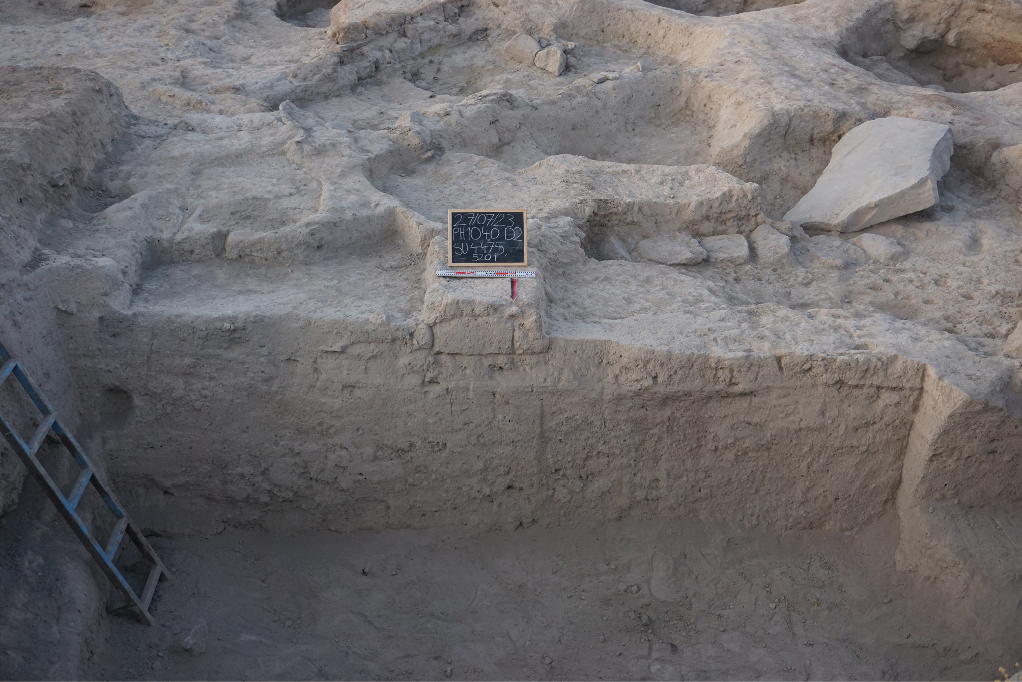
During Phase 4a (Fig. 27), the last sub-phase of this long period, the archaeological evidence points primarily to a gradual process of abandonment of the existing structures, accompanied by minor modifications that attest to the sporadic presence of small groups still inhabiting this sector. In particular, north of Room Dr7 an installation was identified (D4475, D4498, D5206 and D5227), which clearly indicates a brief reoccupation of the area above structures already largely in ruin, though the outlines of the rooms were still perceptible. Another trace of activity was recorded in the outer zone – beyond the fortification wall, no longer standing – where minor reworkings were observed above the collapsed remains of Room Dr10. These features again suggest sporadic use of the area, but no proper architecture in situ. Consequently, only a limited number of stratigraphic units can be attributed to this phase, mainly in those portions of the excavation area where the stratigraphy is best preserved. Phase 4a thus represents the final, residual occupation of the Lower Town before its complete abandonment, preluding Phase 3, which would introduce a completely different architectural character and a fundamentally new form of occupation in the area.
6b. Zooarchaeology
The MIA faunal assemblage (Phase 4) at Kınık Höyük is dominated by domestic livestock, with cattle and caprines forming the core of animal exploitation (Table 5). Cattle account for a substantial proportion of the assemblage by weight, reflecting their importance as primary meat and secondary-product animals. Caprines are numerically dominant and represent routine household consumption. Pigs are present in small numbers; but the presence of infant pig bones with traces of consumption marks indicates the consumption of young pigs or piglets, which may reflect household-level decision-making related to herd management or seasonal availability. Horse, donkey, and dogs occur sporadically. Fragmentation is moderate to high, particularly among sheep-sized mammals, consistent with intensive carcass processing and repeated trampling or deposition. The assemblage composition, combined with taphonomic features, strongly supports interpretation as domestic refuse.
| Taxa | NISP | %NISP | Weight(g) | %Weight |
|---|---|---|---|---|
| Mammal (cattle-size) | 40 | 17.09 | 570 | 20.39 |
| Mammal (sheep-size) | 95 | 40.60 | 349 | 12.48 |
| Mammal (indet.) | 36 | 15.38 | 75 | 2.68 |
| Bos taurus – cattle | 17 | 7.26 | 1144 | 40.92 |
| Ovis aries – sheep | 16 | 6.84 | 199 | 7.12 |
| Capra hircus – goat | 6 | 2.56 | 52 | 1.86 |
| Caprine – sheep/goat | 10 | 4.27 | 126 | 4.51 |
| Sus domesticus – pig | 6 | 2.56 | 69 | 2.47 |
| Equus caballus – horse | 2 | 0.85 | 51 | 1.82 |
| Equus asinus – donkey | 3 | 1.28 | 121 | 4.33 |
| Canis familiaris – dog | 2 | 0.85 | 36 | 1.29 |
| Homo sapiens – human | 1 | 0.43 | 4 | 0.14 |
| Total | 234 | 100 | 2796 | 100 |
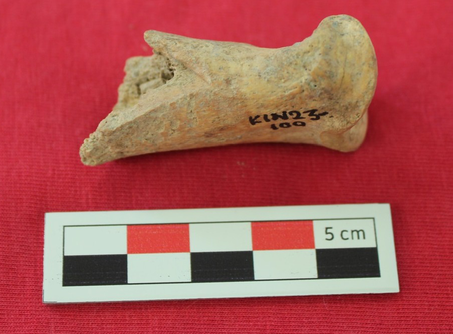
Equid remains, though limited in number, exhibit clear anthropogenic modification. A donkey humerus (KIN23D4888s47) and a donkey first phalanx (KIN23D4889s50) display chopping and slicing marks (Fig. 28), while horse remains also show butchery traces. These modifications suggest occasional consumption of equids (hippophagy) rather than incidental deposition or natural death.
Dog remains are rare but noteworthy. A nearly complete dog mandible with multiple slicing marks on its ventral surface provides potential evidence for cynophagy, although, as with equid consumption, the low frequency of remains suggests this was not a dominant or routine practice.
Butchery marks are widely distributed across cattle, caprine, and pig remains. Butchery includes slicing, chopping, and bashing marks indicative of skinning, disarticulation, and marrow extraction. Several contexts show clear evidence for systematic carcass processing, including midshaft chops on long bones.
Burning is generally scarce and limited to a small number of cattle, caprine, and pig bones, indicating that cooking or disposal in hearths occurred but was not intensive. Gnawing marks are most frequent on cattle bones, suggesting post-discard access by carnivores, while other taxa show minimal gnawing. Weathering is limited, implying relatively rapid burial or deposition of refuse.
A human fetal humeral bone was recovered from one context alongside domestic refuse. This element is best interpreted as resulting from secondary disturbance of burial contexts rather than intentional deposition. Similar mixing of faunal and human remains has been documented in other phases at Kınık Höyük and likely reflects long-term reuse and disturbance of occupation areas.
The zooarchaeological evidence from Phase 4 indicates a stable domestic economy focused on cattle and caprine husbandry, with limited but clear evidence for pig rearing. Butchery practices were systematic and consistent, reflecting well-established household food-processing routines. The sporadic presence of butchered equids and dogs suggests that hippophagy and cynophagy occurred occasionally but did not form a regular component of the diet. Overall, the MIA faunal assemblage shows a standardized pattern of carcass processing and disposal typical of domestic contexts, occasionally mixed with disturbed human remains.
6c. Paleoethnobotany
Paleoethnobotanical analyses were conducted on nine samples from Phase 4. Most of these materials derive from secondary contexts, except for two samples retrieved from occupation surfaces within Room Dr7 (KIN21D4353s107, KIN21D4353s119; Phase 4c) (Table 9, available online in supplementary material). Concentrations of botanical macro-remains are also very low, consisting only of small quantities of charcoal fragments larger than 2 mm (0.015 g/L), nine seeds/fruits from economic plant, and 44 from wild or weedy taxa.
Wood charcoal fragments larger than 4-mm were retrieved exclusively from two flotation samples: KIN21D4353s119 and KIN18D3206s60. Considering the very low count values, quantitative considerations are to date not possible. Identified taxa include the apple/pear subfamily (Maloideae; 2 fragments), deciduous oak (Quercus sp. deciduous; 4 fragments), grapevine (Vitis vinifera; 1 fragment), and Scots pine type (Pinus sylvestris-type; 3 fragments). This flora is consistent with the broader assemblage discussed by Castellano (2021), which also includes coeval samples from other excavation areas. Of note is the presence of grapevine charcoal, which supports the evidence for vineyards in the surrounding landscape and the use of pruning residues as firewood (Castellano 2023). Grape seeds are, moreover, recovered from KIN21D4360s152 and KIN21D4387s195.
In addition to the aforementioned grape seeds, economic taxa are otherwise restricted to small numbers of cereals and pulses: hulled barley (Hordeum vulgare) is represented by four grains, free- threshing wheat (Triticum aestivum/durum) by two grains, and single cotyledon of a pulse remains unidentified. Despite being represented almost exclusively by single occurrences, the wild and weedy flora is comparatively diverse. Identified taxa include members of the Boraginaceae (Heliotropium sp.; Lithospermum/Arnebia), Caryophyllaceae (Silene sp.), Chenopodiaceae (Atriplex sp.; Chenopodium sp.; Suaeda sp.), Cyperaceae (Bolboschoenus glaucus; Carex sp.; Fimbristylis sp.), Fabaceae (Trifolium/Melilotus-type; Trigonella-type), Lamiaceae (Ajuga/Teucrium), Poaceae (Poaceae s.l.), and Solanaceae (Hyoscyamus sp.) families. The incorporation of these taxa into the archaeobotanical record may reflect the burning of cereal-processing waste or dung.
6d. Pottery from Room Dr10 (Phase 4b)
The ceramic assemblage under discussion consists of a selection of 23 MIA shapes (out of 64 diagnostic sherds studied for this context), representative in quantity and type for the ceramic found in Room Dr10, above the plaster floor of the room (see above). Examples from both open (12) and closed (11) forms are available. The range of ware types illustrates a functional repertoire dedicated to domestic activities, including cooking, storage, serving, and consumption of food and drinks. The most frequent category is that of bowls, followed by cooking pots, jars, and kraters. There is also a similar distribution of decorated wares (11) and plain (12) wares in numbers, resembling a functionally domestic assemblage, yet with a specific attention in the pottery production.
Bowls are the best represented group, 12 in total, arranged into two sub-shapes (shallow bowls, 8 items, and deep bowls, 4 items), based on the ratio between rim diameter and reconstructed height. Among the shallow bowls, one fragment is a simple hemispherical bowl (Fig. 29a), two fragments show internally thickened rims: Fig. 29l finds comparison at Porsuk Höyük, (Dupré 1983: pl. 9 n. 47–48), and Fig. 29e, with a painted decoration on the rim consisting of vertical lines. Fig. 29e is distinctive because of the particular painted black motifs of vertical lines on rim, “S” motifs on the external wall and horizontal bands on body; its form that can be seen in a similar context at Kınık Höyük Lower Town in Room Dr7 (Fantoni 2025: pl. 2, KIN21D4353c4329, pl. 4351, KIN4321D4353c4340), Boğazköy (Genz 2004: pl. 41 n. 42), and Porsuk Höyük (Dupré 1983: pl. 60 n. 4). Another distinctive bowl is Fig. 29d, a carinated bowl with everted flattened rim, which resembles items found in the Destruction Levels of Gordion (Sams 1994: fig. 13 nos 450–461) and Boğazköy (Bossert 2000: pl. 83 n. 995, 1014, 1015, 1025). A particularly noteworthy piece is Fig. 29k, a shallow bowl with a tapered rim, decorated with wavy lines and dot-filled squares. In terms of its form, comparisons come from Gordion and Kuşaklı’s Iron Age levels (Sams 1994: fig. 20 n. 503, Powroznik 2010: pl. 19 n. 25). Since its decoration is distinctive, it is significant to mention that parallels in motifs are seen in Dr7 (Fantoni 2025: pl. 12 KIN21D4353.45.F90), Alişar (von der Osten and Schmidt 1932: pI XLVI n. b1182:1188), and Göllüdağ (Tezcan 1992: fig. 12). Fig. 29c, a shallow bowl with angular painted bands on an everted rim is the last example of shallow bowls. Internal parallels within Kınık Höyük include KIN21D4353c28+F75 and KIN21D4353c27 (Fantoni 2025: pl. 2 and pl. 3) in terms of form and decoration, while comparanda are attested in Gordion (Sams 1994: fig. 20 n. 503), Kuşaklı (Powroznik 2010: pl. 19 n. 25), Boğazköy (Bossert 2000: pl. 79 n. 940), Porsuk (Dupré 1983: pl. 73 n. 98), and Kaman-Kalehöyük (Matsumura 2005: pl. 112 KL188-P122), hereafter Kaman. Fig. 29a is representative of a thin, simple rim, where comparison is available in Gordion (Sams 1994: fig. 19 n. 49, fig. 20 n. 503).
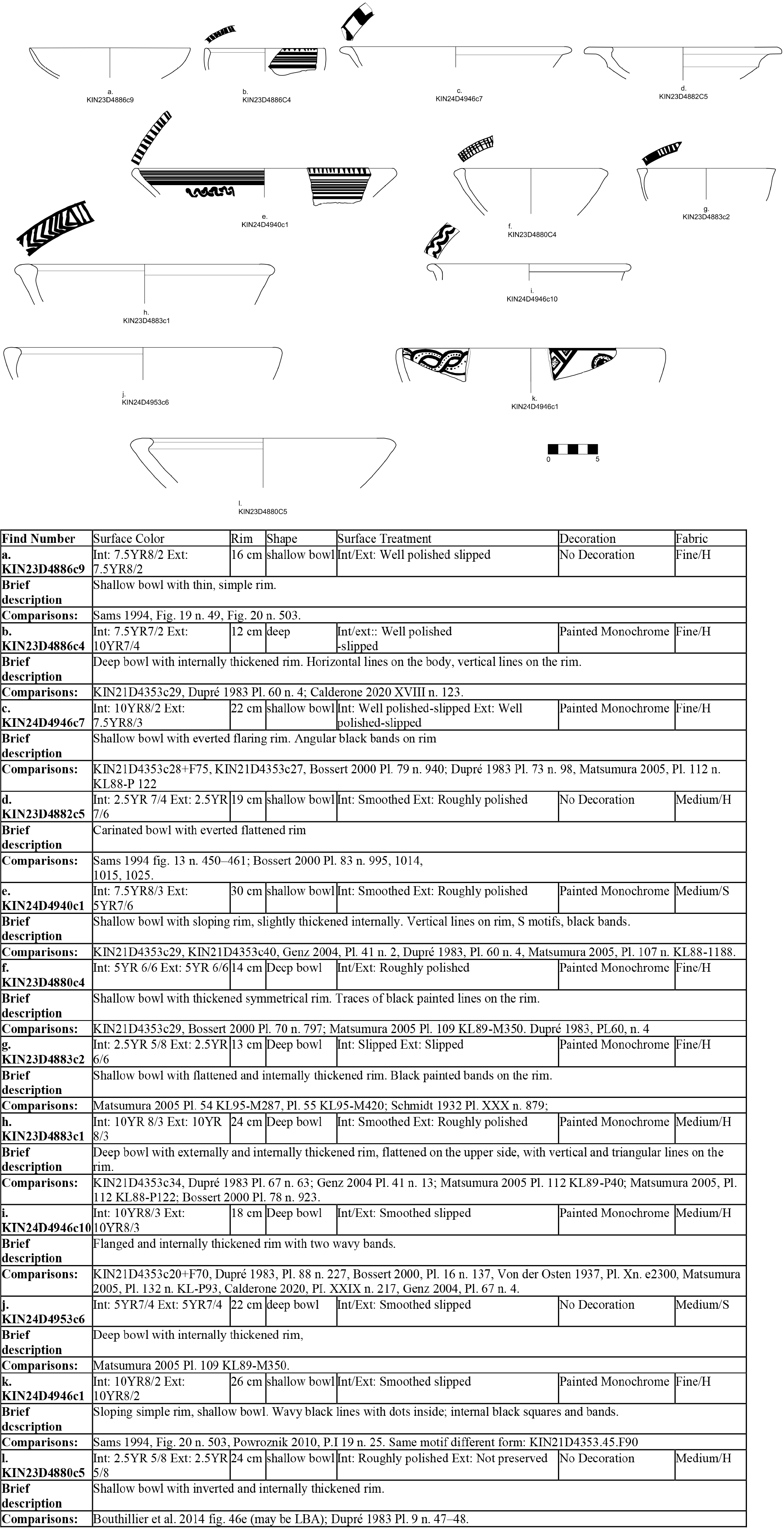
Regarding the deep bowls, three of them are characterised with internally thickened rims (Fig. 29h, b and j). The first two also have a painted motif on the rim, as is common. They have parallels respectively in Dr7 (Fantoni 2025: pl. 4, KIN21D4353c34), Porsuk (Dupré 1983: pl. 67 n. 63), Boğazköy (Genz 2004: pl. 41 n. 13; Bossert 2000: pl. 78 n. 923), Kaman (Matsumura 2005: pl. 112 KL89-P40 and pl. 112 KL88-P122), and for the second piece in Kınık Höyük (Fantoni 2025: pl. 2, KIN21D4353c29), and Porsuk (Dupré 1983: pl. 60 n. 4). The fourth deep bowl Fig. 29i preserves a flanged and internally thickened rim with two wavy painted bands; internal parallels include KIN21D4353c20+F70 (Fantoni 2025: pl. 6), with comparanda in Porsuk (Dupré 1983: pl. 88 n. 227), Alişar (von der Osten 1937: pl. Xn e2300), Kaman (Matsumura 2005: pl. 132 KL-P93), and Boğazköy (Genz 2004: pl. 67 n. 4; Bossert 2000: pl. 16 n. 137). For the same group, two bowls with thickened symmetrical rim and black painted decoration on the rim are available: Fig. 29g (parallels in Kaman, and Alişar Höyük, Matsumura 2005: pl. 54 KL95- M287, pl. 55 KL95-M420; Schmidt 1932 pl. XXX n. 879) and Fig. 29f. Kınık Höyük parallel is again provided by KIN21D4353c29, while comparisons exist in sites like Boğazköy (Bossert 2000: pl. 70 n. 797), Kaman (Matsumura 2005: pl. 109 KL89-M350), and Porsuk (Dupré 1983: pl. 60 n. 4).
Cooking pots are also well attested, but they are characterised by morphological diversity. Fig. 30a is a small pot with an internally thickened rim; Kınık parallels are provided by KIN21D4353F94 (Fantoni 2025: pl. 14) with parallels in Porsuk (Dupré1983: pl. 86 n. 207), Kaman (Matsumura 2005: pl. 128 KL89-M186), Kuşaklı (Powroznik 2010: pl. 45 n. 40), and Kilisetepe (Postgate 2007: fig. 404 n. 907). Fig. 30b is another example, with a simple straight rim and slight carination at the shoulder, comparable to KIN21D4353c58 (Fantoni 2025: pl. 16), Kuşaklı (Powroznik 2010: pl. 48 n. 32), Porsuk (Dupré 1983: pl. 86 n. 206), and Kaman (Matsumura 2005: pl. 127 KL89-M264). Another cooking pot with a flaring, rounded rim and short neck is Fig 30c, paralleled by KIN21D4353c57 (Fantoni 2025: pl. 16), and has parallels in Kuşaklı (Powroznik 2010: pl. 42 n. 18), Kaman (Matsumura 2005: pl. 128 KL89-M378), and Gordion (Sams 1994: pl. 102 n. 846). Fig. 30g, a cooking pot with flaring, rounded rim and short neck, recalls KIN21D4353c57 (Fantoni 2025: pl. 16), while comparanda are attested in Kuşaklı (Powroznik 2010: pl. 42 n. 18), Kaman (Matsumura 2005: pl. 128 KL89-M378), and Gordion (Sams 1994: pl. 102 n. 846).
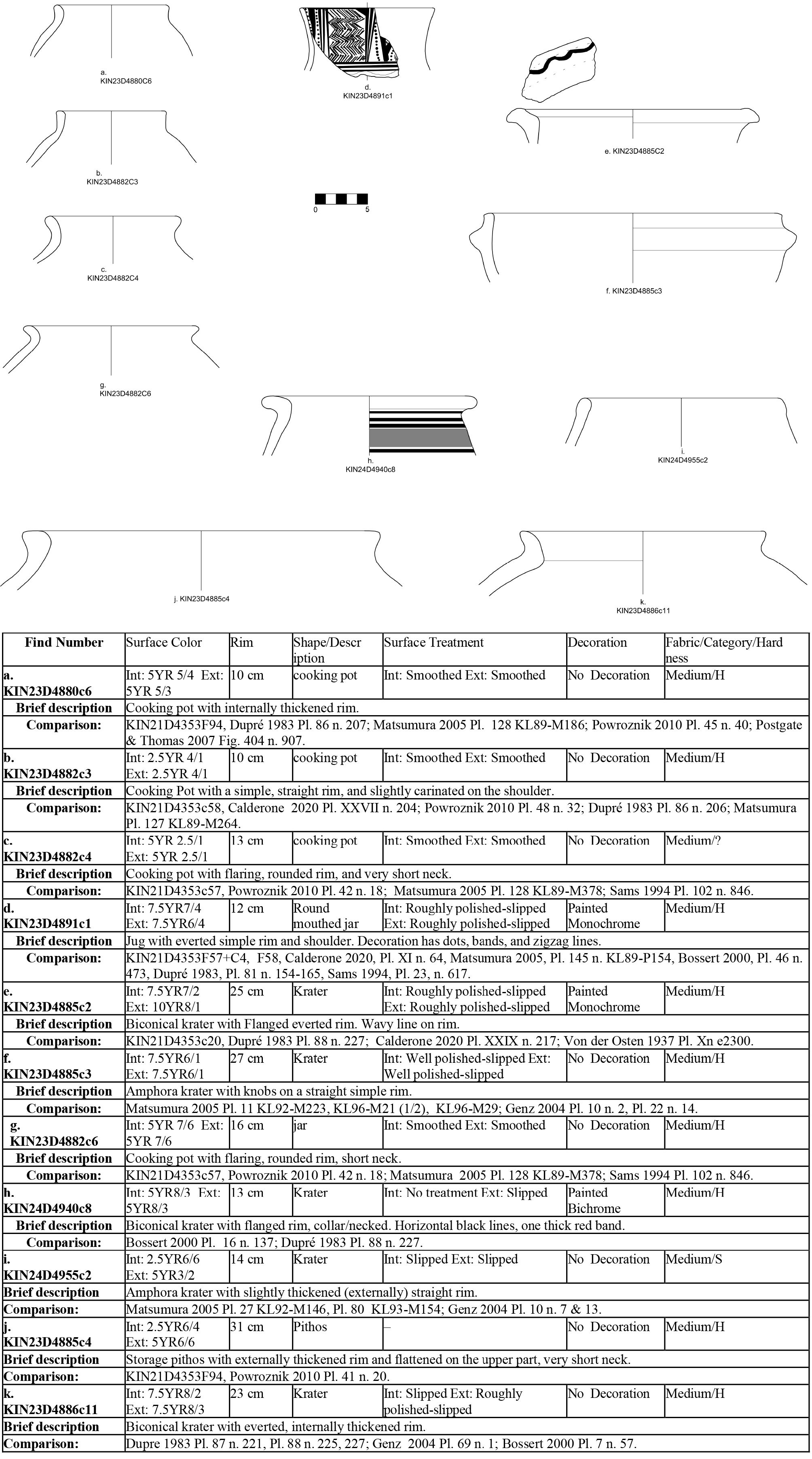
One of the most distinctive sherds of the assemblage is Fig. 30d, a round mouthed jar with an everted rim and painted decoration of dots, bands, and zigzags. Internal parallels are attested in KIN21D4353F57 and KIN21D4353F58, while significant comparisons in terms of form and similar motifs are in Kaman (Matsumura 2005: pl. 145 KL89-P154), Boğazköy (Bossert 2000: pl. 46 n. 473), Porsuk (Dupré 1983: pl. 81 n. 154–165), and Gordion (Sams 1994: pl. 23 n. 617). Kraters are the other significant group for comparison to other Iron Age contexts of the region. We can divide them into two sub-groups in this context: biconical and amphoroid krater. Fig. 30e is a large krater with flanged everted rim decorated with a wavy painted line; internal parallels are found in KIN21D4353c20 (Fantoni 2025: pl. 6), while external comparanda come from Porsuk (Dupré 1983: pl. 88 n. 227) and Alişar (von der Osten 1937: pl. Xn e2300). Fig. 30k is a krater with an everted, internally thickened rim, comparable to KIN21D4353c20 (Fantoni 2025: pl. 6), with parallels again in Porsuk (Dupré 1983: pl. 87 n. 221; pl. 88 n. 225, 227), and Boğazköy (Genz 2004: pl. 69 n. 1; Bossert 2000: pl. 7 n. 57). Another addition to the biconical krater group is Fig. 30h with a flanged rim and bichrome decoration consisting of black horizontal lines and a thick red band. Parallels in form and motif are from Boğazköy (Bossert 2000: pl. 16 n. 137) and Porsuk (Dupré 1983: pl. 88 n. 227). Fig. 30f is one of the two amphoroid kraters and it is distinctive in its form with knobs on a straight simple rim. Notable comparanda come from Kaman and Boğazköy (Matsumura 2005: pl. 11 KL92-M223, KL96-M21 (1/2), KL96-M29; Genz 2004: pl. 10 n. 2, pl. 22 n. 14). Fig. 28i is the other amphoroid krater with slightly thickened rim, finds parallels in Kaman (Matsumura 2005: pl. 27 KL92-M146; Pl. 80 KL93-M154) and Boğazköy (Genz 2004: pl. 10 n. 7 and 13). A larger form is Fig. 30j, a storage pithos with externally thickened rim, paralleled internally at KIN21D4353F94 (Fantoni 2025: pl. 14) and externally in Kuşaklı (Powroznik 2010: pl. 41 n. 20).
In terms of fabrics and treatment, the majority of the assemblage consists of medium and hard wares, with fine fabrics reserved for decorated bowls such as Fig. 29c and Fig. 29g. Surface treatments are mainly slip and smooth in numbers, but we also observe roughly and well-polished examples, mostly within bowls, jugs, and kraters. Painted decoration, almost always monochrome, predominates the assemblage, with motifs including horizontal bands, wavy lines, angular designs, as well as significant Alişar IV style zigzags and dots. Another point to underline is that we see a diverse number of sites in the region showing parallels within every category of forms. These parallels apply to both form and decorations, and these compared contexts come from attested MIA sites within Central and South Anatolia. Kınık Höyük’s Dr7 also shows parallels for form and/or decorations in the majority of sherds (16) of the assemblage from Dr10 and related SUs.
6e. Pottery from Room Dr7 (Phase 4b)
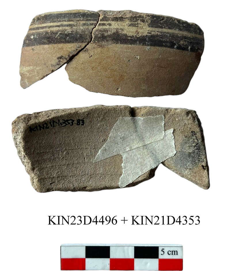
Part of the ceramic assemblage from Room Dr7 was already presented in the 2023 preliminary report, and, as it is the subject of an ongoing doctoral dissertation, the complete inventory will be published in full in due course. With regard to the ceramic assemblage, it should be emphasized that numerous large sized sherds (D4496) were recovered in Space Ds8. These, however, did not appear to be directly connected with the use of this space, as they were found at a much higher level than its presumed floor surface. A close analysis of this group of ceramics from Ds8, compared with the inventory of Room Dr7, has shown that these sherds were part of the assemblage ascribed to Room Dr7, they were displaced as a result of later levelling activities, carried out most likely during Phases 3 and 2. The ceramic repertoire presented here, despite not being situated within a primary context, can be associated with the context of Room Dr7, as two fragments (one from each context), albeit diminutive and non-diagnostic, join (Fig. 31). This finding lends support to the hypothesis that, subsequent to the levelling operations conducted in the area during later periods, the assemblage was spread beyond the limits of the room, extending into the northern area.
The material examined consists of approximately 20 fragments, selected from among the most representative of the context, including both open and closed forms, with a prevalence of containers intended for the consumption of food and drink or for serving them. Containers intended for medium or long-term storage were not found; only a fragment belonging to a cooking pot was discovered. Its chronological placement is consistent with the MIA, a period also evidenced in the repertoire of Room Dr7 (as cited in Pucci et al. 2023). In this particular case study, the primary comparisons were made with the findings dated to the MIA levels of some selected sites (Kaman, Boğazköy, Alişar , Sarissa, Gordion, Porsuk, Tarsus, and Kilise Tepe).
Bowls: the most prevalent shape is that of the bowl, both shallow and deep (Fig. 32). The type is characterised by certain distinctive features. Firstly, the shallow bowls have a diameter of between 20 and 22 cm. Secondly, the rim can be thickened on the outside or more elongated and flaring. Thirdly and finally, the body can be more hemispherical or slightly keeled. Within the group, there is one specimen that is particularly noteworthy for its peculiarity: KIN23D4496c4 (Fig. 32g; Fig. 34). The rim and body of the specimen under consideration are consistent with the MIA tradition for this particular type of shallow bowl, as is the presence of a monochrome painted decoration on the upper part of the rim. The decorative motifs that characterise this specimen are vertical lines and continuous semicircles, with the addition of a central dot, a less common element in contemporary ceramic repertoires. However, less common features include the presence of decoration extending over the entire outer surface, divided into several registers and characterised by geometric motifs. Furthermore, it possesses a less prevalent form of base in comparison to the conventional ring base that characterises the shallow bowls in Room Dr7. The base comprises three vertical supports, termed “handle-like” due to their resemblance to a handle, which originate from a central structure. These supports are characterised by a component that descends at an almost perpendicular angle, thereby forming a connection to the ring of the base itself via a secondary arm. The vertical sections of the handle-feet are decorated with a pattern of rhombuses, filled with diagonal lines. The motif of concentric triangles arranged in a radial pattern around the base ring and the zigzag line below the rim are among the decorative motifs found inside Room Dr7. The type of bowl with a three-footed base reminiscent of KIN23D4496c4 has been attested in Layer IIc2-3 of Kaman (Matsumura 2005: pl. 119 n. KL89-M106; pl. 271 n. KL91-2008), although the shape of the rim and body show significant differences.
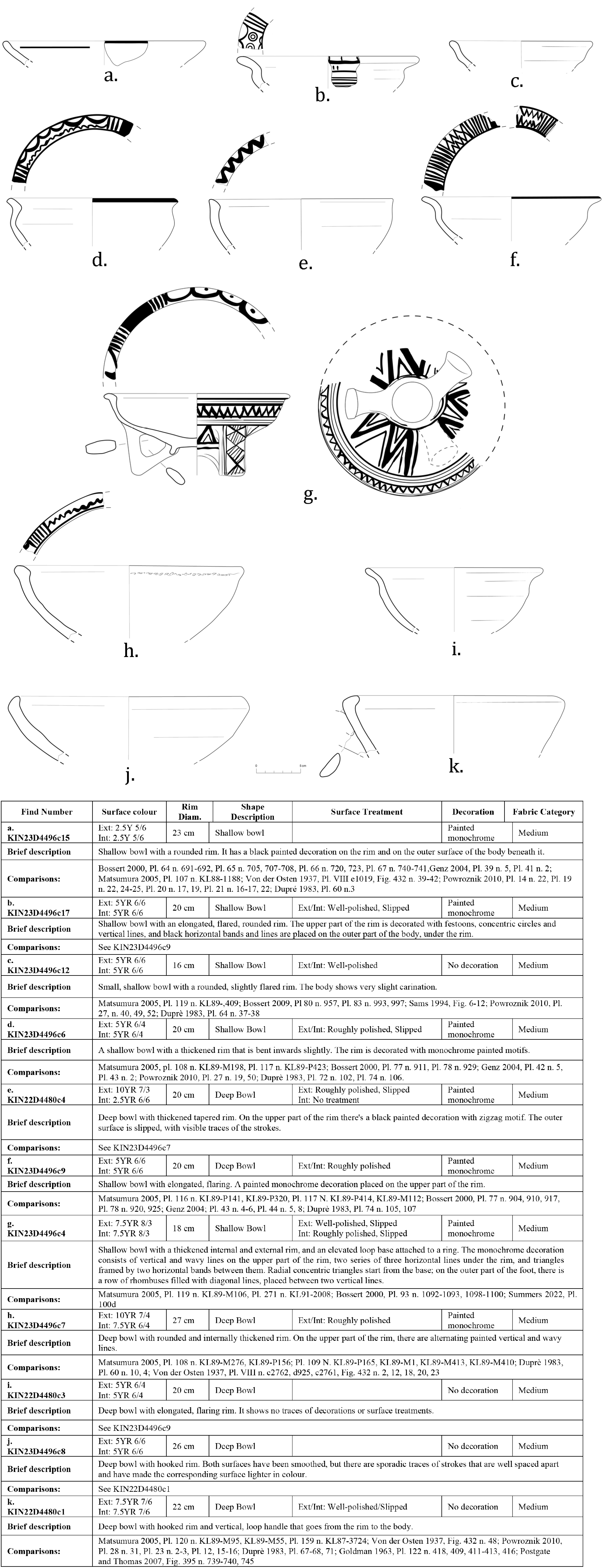
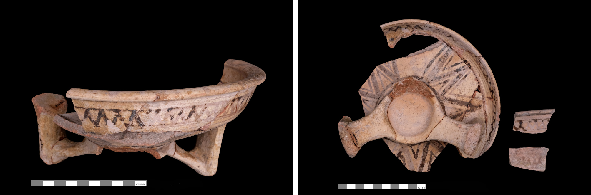
A closely related specimen, exhibiting comparable morphology and decoration, has been discovered in a non-stratified context in Kaman. Bowls with a three-footed base have also been found at Boğazköy, but the morphology of the feet in this case is significantly different and they do not feature decorative elements (see Bossert 2000: pl. 93 n. 1092-1093, 1098-1100). A shallow bowl with a three- footed base was also found in Kerkenes, although the morphology of the feet differs from that of KIN23D4496c4 (Summers 2022: pl. 100d).
In addition to the most prevalent type, characterised by a thickened rim and a monochrome painted decoration on the upper part of the rim, two examples feature a type of rim not found in the Room Dr7 collection. The specimens KIN22D4480c1 (Fig. 32k) and KIN23D4496c8 (Fig. 32j) both exhibit a hooked rim, characterised by slight thinning at the uppermost point. The two artefacts are lacking in decorative elements, exhibiting a coarse fabric and a surface treatment of a lower quality. The burnished finish is poorly executed, and signs of strokes are still visible. It is evident that KIN22D4480c1 exhibits a partial trace of a handle, which was presumably originally situated beneath the rim, extending to the object’s body. It is uncertain whether it was a simple vertical loop handle or if it was composed of two coils or even braided. The dimensions of the bowls are consistent with those typically associated with deep bowls, with KIN22D4480c1 exhibiting a slightly smaller diameter of approximately 22 centimetres, while KIN23D4496c8 (Fig. 33j) has a diameter of 26 centimetres. Hooked rims are widely represented at Kaman, with one example retaining a vertical strap handle attached directly to the rim, as evidenced in the case of KIN22D4480c1 (Matsumura 2005: pl. 120 n. KL89-M95, KL89-M55; pl. KL87-372). Hooked rims have been observed at Alişar, as have bowls with handles; however, the joint presence of these two elements has not been documented (von der Osten 1937: fig. 432 no. 48). In contrast, the hooked rim type is prevalent at Sarissa, as are bowls with horizontal handles; KIN22D4480c1 could represent a variant of the latter (Powroznik 2010: pl. 23 no. 2, 3). Examples of bowls with handles are also extant from Porsuk (Dupré 1983: pl. 71), as well as from Tarsus, where this type is particularly widespread, especially with horizontal handles. However, the hooked rim type is not present (Goldman 1963: pl. 122 nos 409, 411-413, 416).
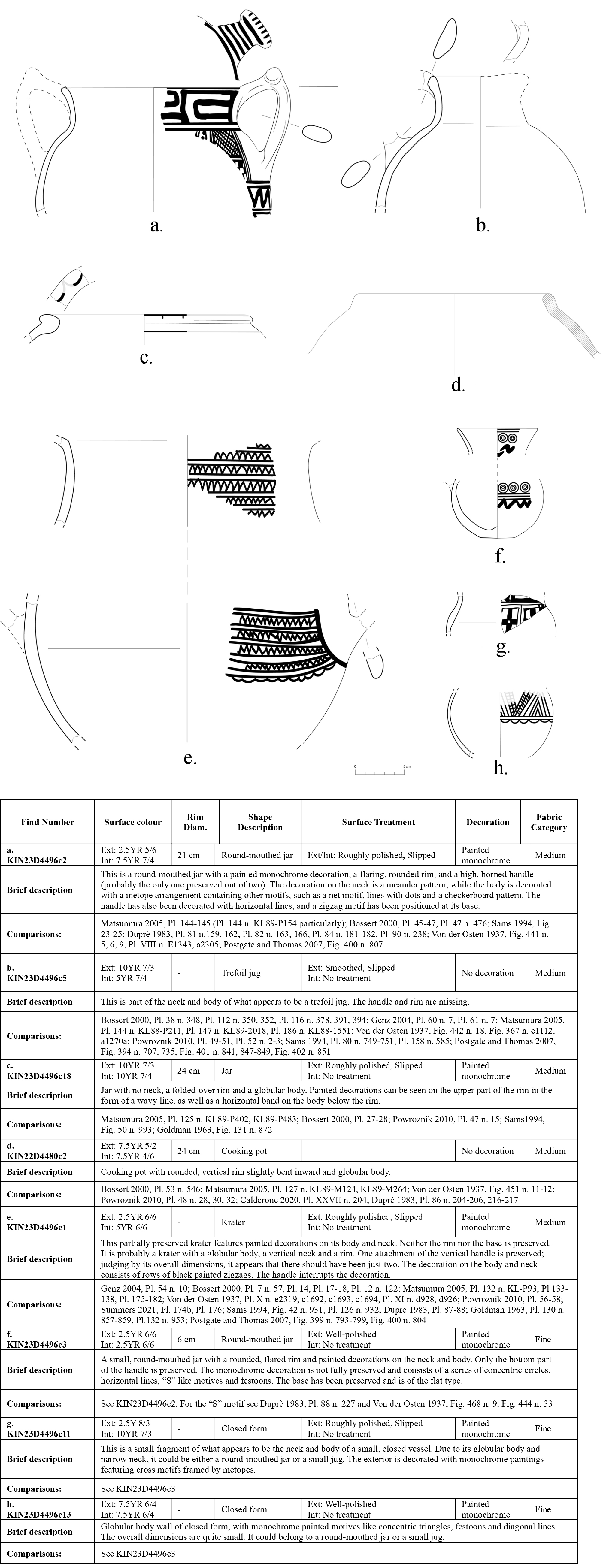
Jars: Another widely documented form within this context that adequately reflects the typological and decorative tradition of MIA ceramics is the round-mouthed jar. This is characterised by a straight or slightly flared rim set on a slightly flared neck and a globular body. There are two examples of this type of jar. One larger specimen, identified with the code KIN23D4496c2 (Fig. 33a; Fig. 35), has a preserved raised horned handle, although it probably had two. It has a slightly flared rim and a clearly distinct globular body. Another specimen, KIN23D4496c3 (Fig. 33f), is considerably smaller and only retains the handle attachment to the globular body. The rim is flared and shows obvious thinning. Both specimens feature black painted decoration with geometric motifs. KIN23D4496c2 has a meander decoration on the neck and body divided into metopes containing net motifs, chequerboard, dotted lines, and zigzag patterns below the handle. The handle itself is decorated with vertical and horizontal lines. Similar specimens were found at Kaman (Matsumura 2005: pls 144–145, KL89–P154) and Boğazköy (Bossert 2000: pls 45–46, Pl. 47, n. 476). While the examples vary in terms of size and decorative motifs, they exhibit a notable similarity, suggesting the possibility of a shared origin or stylistic correlation. Numerous examples are also found in Gordion (Sams 1994: figs 23-25), one of which has the same meander decoration on the neck (Sams 1994: fig. 24 no. 640). It is evident that a considerable number of examples from Porsuk demonstrate notable parallels with KIN23D4496c2, evident in both the morphology (Dupré 1983, pl. 84 nos. 181-182) and the decorative elements (Dupré 1983: pl. 81 nos. 159, 162; pl. 82 no. 164, 166 for the meander decoration on the neck; pl. 90 no. 238 for the type of handle and the arrangement of the decorations). The analysis of KIN23D4496c3 demonstrates that the decoration does not consist of metopes, but rather of simple alternating registers comprising concentric circles, horizontal lines and side-by-side “S”-motifs. This decorative motif has been identified in both Porsuk (Dupré 1983: pl. 88, no. 227) and Alişar (von der Osten 1937: fig. 444, no. 33; fig. 468, no. 9).
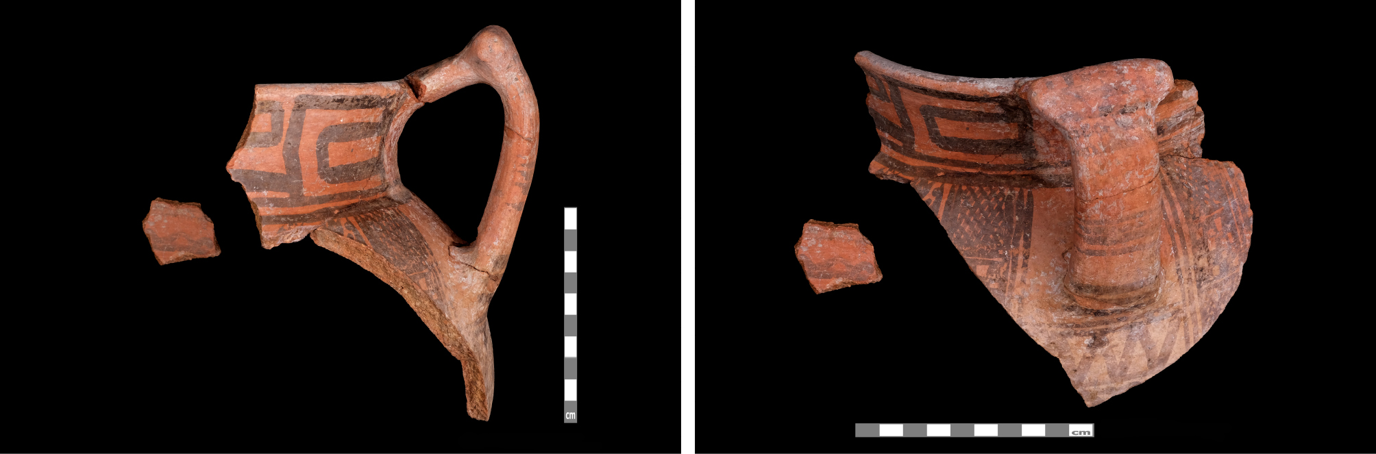
Krater: Another form that fits coherently into the MIA ceramic context is represented by KIN23D4496c1 (Fig. 33e). Although the specimen is not fully intact, it is notable for being a medium-sized krater with a globular body and a clearly distinct vertical neck. While the rim and base are not preserved, the lower attachment of the vertical handle, which appears to belong to a set consisting of at least two handles, is present. The entire outer surface of the body and neck is decorated with black paint and geometric motifs arranged in registers. These motifs consist of continuous zigzag lines bordered at the bottom by a festoon line. The handle attachment shows signs of painted decoration, probably consisting of simple horizontal lines. Notably, the decoration is enclosed within a metope that adapts to the shape of the handle and undergoes deformation as a result. The decoration is not particularly precise; the zigzags appear imprecise and irregular. Kraters of this type are widespread in Central Anatolia (Bossert 2000: fig. 7, 57. 7, n. 57; pl. 14, pl. 17–18, pl. 12, no. 122; Matsumura 2005: pl. 132, no. KL-P93, Pl. 133–138, pl. 175–182; von der Osten 1937: pl. X, no. e2319, c1692, c1693, c1694; pl. XI, no. d928, d926; Powroznik 2010: pl. 56–58; Summers 2021: pl. 174b, pl. 176). A precise analogy can also be observed for the decoration present in Boğazköy, where zigzags are arranged in overlapping rows (Genz 2004: pl. 54, no. 10).
Cooking pot: The only example of a cooking pot found within the archaeological context is KIN22D4480c2 (Fig. 33d), characterised by a predominantly globular body that is slightly curved inwards, which fits perfectly into the context of the MIA of the Central Anatolian area (Bossert 2000: pl. 53 no. 546; Matsumura 2005: pl. 127 n. KL89-M124, KL89-M264; von der Osten 1937: fig. 451 n. 11-12; Powroznik 2010: pl. 48 n. 28, 30, 32; Dupré 1983: pl. 86 nos. 204-206, 216-217).
The repertoire examined has therefore been shown to confirm the dating of the context to the late 9th century BC – early 8th century BC. In addition, the repertoire has been associated with the adjacent Room Dr7. Room Dr7 was presumably used as a storeroom for ceramic containers intended for a variety of different uses. These containers are shown to have been used for preparation, storage, service, consumption, transport and small containers. The material analysed within the context under examination, situated in the corner adjacent to Room Dr7, exhibits a similar diversity in terms of shapes and functions.
7. The Late Iron Age organisation of the area (Phase 3)
7a. Stratigraphy and architecture
At the onset of Phase 3, only a few topographic features inherited from earlier periods were still perceptible. The western portion of the area continued to slope downwards towards the west, while the southern sector showed a marked descent towards the south. These gradients were still clearly visible in this phase. By contrast, in the zone corresponding to Room Dr7, the Phase 4 Street (Ds13), and adjacent spaces, no significant irregularities were detected, suggesting a levelled surface. Thus, these residual slopes represent the only traces of the earlier landscape that remained recognizable at the beginning of Phase 3.
Phase 3 has been subdivided into two sub-phases, with 3b representing the earlier stage and 3a the later one. This distinction is based primarily on the different phases of use identified for the installations associated with this occupation. From a chronological standpoint, the dating of the later phase (3a) relies on the analysis of the ceramic assemblage and its correspondence with established ceramic sequences; no radiocarbon samples are currently attributable to this phase.
Overall, Phase 3 is characterised by a complete reorganization of the area, which no longer reflects the spatial layout of the Iron Age or the modified topography inherited from the MBA. Instead, it is defined by the presence of large oval installations (Fig. 36), set along the former western slope of the MBA fortification wall D5454 and a series of rounded pits located in the central sector of the area.
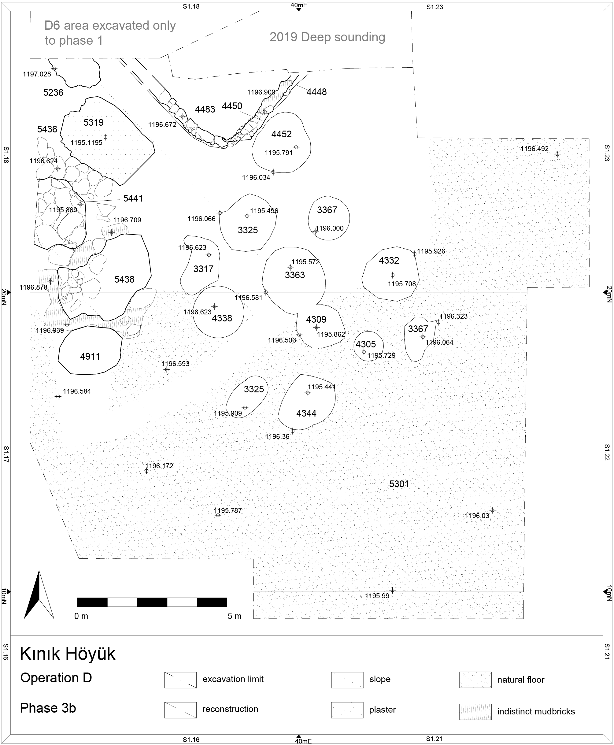
The distinction between Phases 3b and 3a is primarily based on the fills of the ovoid installations. Phase 3b corresponds to their use, represented by the deeper deposits that display markedly different characteristics from the later fills. Phase 3a, by contrast, marks the moment when these installations went out of use and were progressively filled, first by the natural collapse of the surrounding deposits and later by activities associated with the preparation of Phase 2.
All the ovoid installations identified so far are located along the western edge of the excavation area (Fig. 37). To the north lies installation D5236, only partially excavated since it extends beneath the excavation limit; here, only the upper fill (D5235) belonging to Phase 3a has so far been documented. Immediately to the south is installation D5436 (D5428, 5229), of considerable size, which was entirely cut into the mudbrick mass of wall D4319. With its almost rectangular shape, flat base, slight plaster traces on the bottom, and multiple superimposed fills, this feature presents, in its earliest phase of use (3b), deposits (D5228) not characterised by ash but rather by the gradual decay of mudbrick and in its later several deposits with larger fragments of mudbrick (D5437, D5429, D5311). The bottom one (D5228) yielded a clay spindle whorl (KIN24D5228F4).
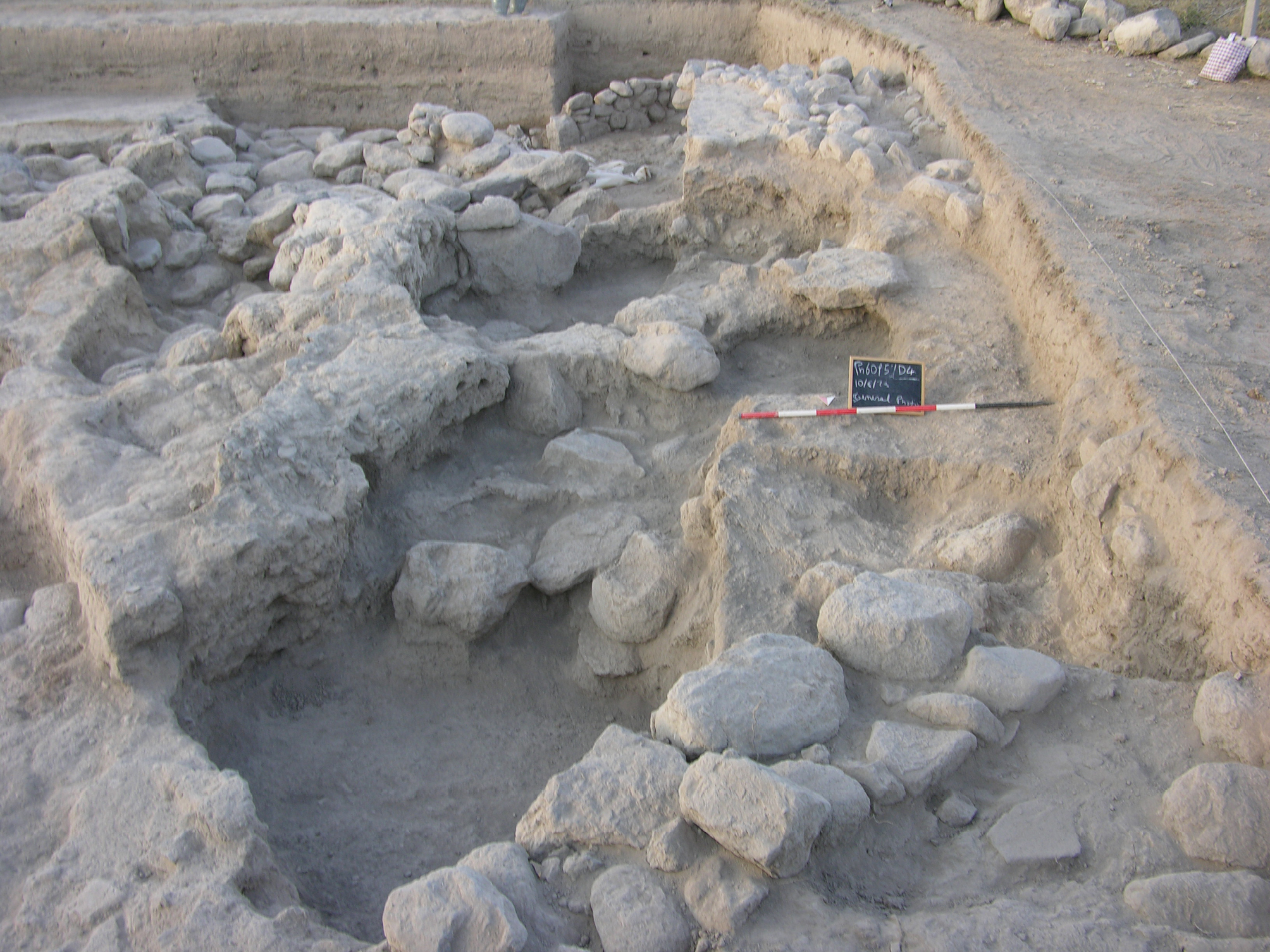
Further to the SW lies installation D5441 (D5418), oriented east–west (unlike the previous examples, aligned NW–SE). This installation was cut into the deposits down to the stone foundations of wall D5454 and partially reused stones from the fortification, some of which were displaced and set aside along its edges. Its stratigraphy shows a lower, partly ashy fill (D5419–D5414) and an upper fill (D5420–D5439) characterised by mudbrick debris and abundant slag. The pit itself appears to terminate against the lowest preserved course of wall D5454.
Immediately south of this feature lies installation D4386 (D5438), separated from D5441 by a makeshift stone partition. Like D5441, it cuts into both the stone structure of wall D5454 and the adjacent deposits to the west. In this case, in the eastern part of the cut – where the installation directly impacted the MBA fortification – the removal of a large block was compensated by setting small stones in place, creating a framed limit for the pit. On the eastern side of the cut – where the installation intruded into the MBA fortification – the removal of a large stone block was compensated by the placement of small stones, forming a makeshift boundary for the installation. As with the other examples, the fills consist of a lower, ashy deposit directly connected with its use, overlain by successive strata rich in debris from wall collapse.
The fill is especially noteworthy (Fig. 38): within the deepest and most ashy deposit (D5421, D5440, D4387), which likely relates to the installation’s phase of use, a group of about thirty loom weights was recovered (KIN23D5421F1). These weights (Fig. 39), some fragmentary, share the same truncated pyramidal or conical shape with rectangular or square bases, are made of unbaked clay, and frequently bear traces of burning. Their average weight hovers around 40 grams.
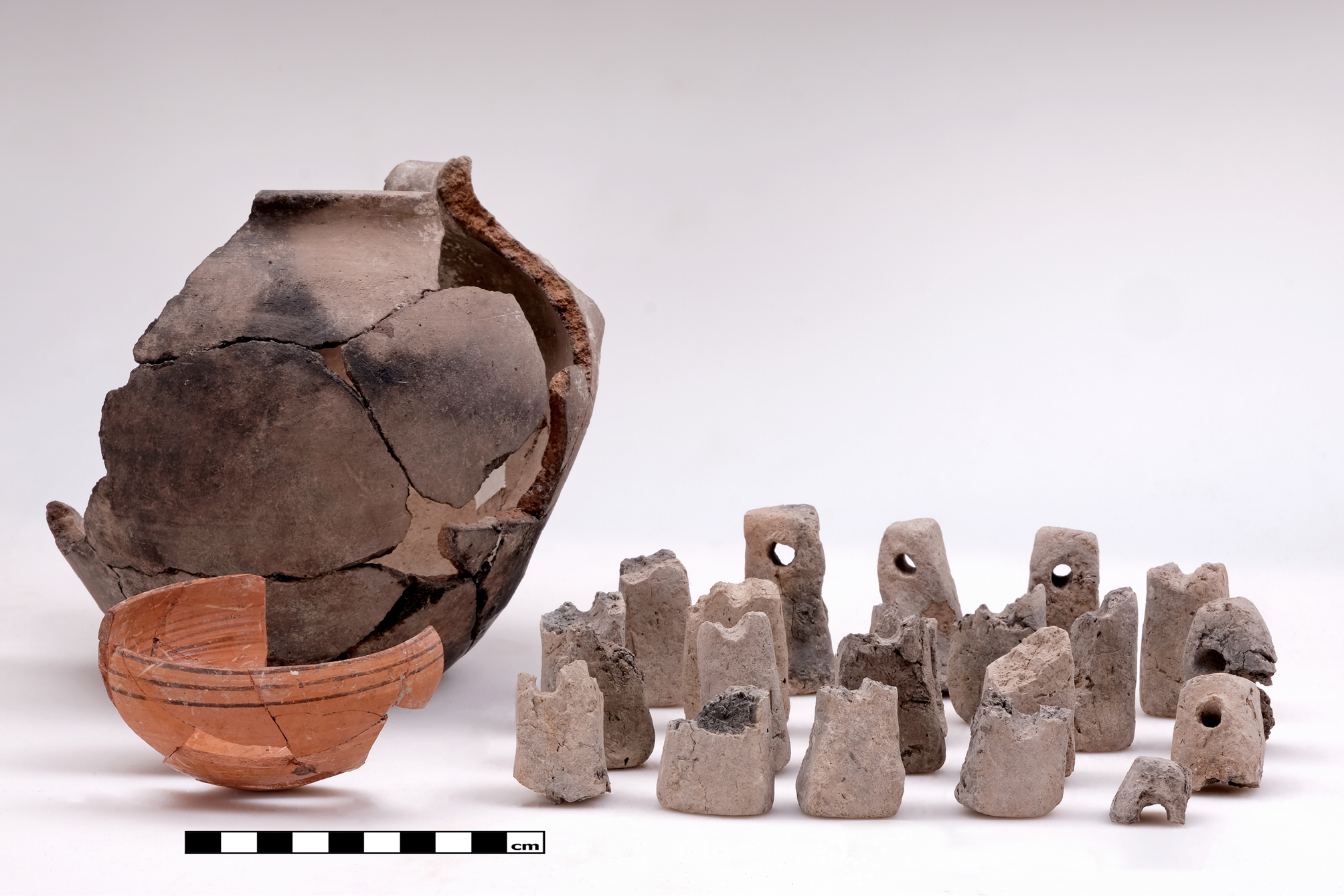
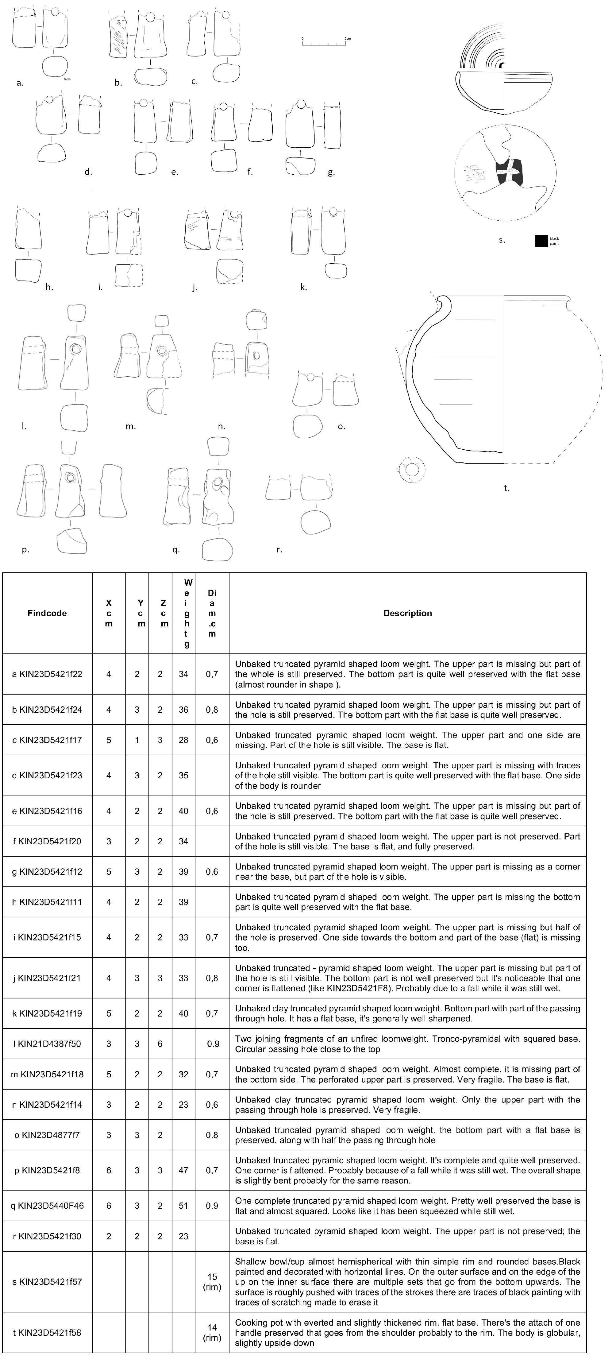
Comparable sets of unbaked clay weights of identical form have been documented at Sardis, in the so-called Lydian I phase, particularly in Building D (Ramage et al. 2021: 98, no 645). The main difference lies in the lighter weight of the Kınık specimens, which suggests the weaving of different, presumably lighter, textiles.
Associated with this assemblage were two complete ceramic vessels (Figs 38-39). The first is a cooking pot (KIN23D5421F58, Fig. 39t) with an out-turned rim, flat base, and probably one vertical high swung strap handle, preserved for about three-quarters of its form and bearing clear traces of burning on its exterior. The shape of the cooking pot again finds similarities with cooking pots from Sardis (Ramage et al. 2021: cat. no HoB49 and HoB 580): flat base, single high handle, globular body recur in both the examples from Sardis and the one from Kınık. The date range is the end of the 7th century and beginning of the 6th century BC. The second complete vessel found in this assemblage is a hemispherical bowl (KIN23D5421F57, Fig. 39s) characterised by very thin walls and a fine fabric. It is decorated with black-painted parallel lines on the interior surface and outer rim, and on the base features a reserved cross created by removing the black paint from the base before firing, with traces of this process still visible. The shape, hemispherical bowl, belongs to the local tradition already featured in the MIA, however, it is decorated with black-painted parallel lines on the interior and outer rim, and on the exterior base it carries a cross executed in reserve against a dark ground. Such crosses, painted in reserve, at the external base of a bowl find parallels only among so-called lids from the Early Greek cemetery of Knossos (Coldstream et al. 1996: cat. no 53 vol. III). However, the rest of the decoration – thin lines – does not find any close comparanda.
The southernmost of the ovoid installations is D4911, which, unlike the others, scarcely cuts into the MBA fortification and instead largely intrudes into the compact archaeological deposits lying to its west. This installation, which lacks any stone lining, is simply cut into the dense deposits, but its stratigraphy mirrors that of the other examples: deeper, ashy fills (D4910, D4916, D4918, D4378, D4380)9 associated with its phase of use, and a higher fill (D4921,D4923) of reddish mudbrick debris marking its later abandonment. All the ovoidal installations described so far were accessible only from above and not laterally. Some of them are preserved to a depth of about 1–1.20 m. In the northern part of the sector, where the installations are particularly close to one another, no clear floor surface from which they had been cut could be identified. It is, however, evident that in this area the installations cut not only through the collapse of the Phase 6 structures (D5438, D5441, D5229, D5236) but probably also into the surfaces associated with the occupation of Phase 4, which in this zone had not yielded substantial architectural evidence.
The situation is different in the southern portion of the area (Fig. 36), where the topography slopes down and the installation levels are consequently lower: here the structures were not cut directly into the rise formed by the remains of the MBA wall, but further to the west. In this context, the deposits into which the installations were dug are clearly recognizable, characterised by abundant debris from the collapse of mudbrick walls, compacted into thin, well-stratified, and complex sequences. These deposits (D5444, D5452, D5445) most likely derive from partial episodes of use of the area during Phase 4 and can thus be referred to contexts of the Iron Age.
Only south of the ovoidal installation D4911 was it possible to identify a distinct walking surface, designated D4914, D4922, D5301. This is a natural, non-constructed surface extending south of D4911 and covering the entire southern portion of the excavation area, reaching the eastern limit of the sector. Its absence in the central zone is most likely due to earlier excavations, while the southern part is well preserved thanks to greater sediment accumulation resulting from the slope and to the reduced disturbance from later activities. This surface clearly shows traces of human activity: the formation of thin layers of silt and clay indicates runoff from rainfall, particularly evident in the southernmost part, where the surface slopes downward following the topography already observed in Phase 4, before rising again at the extreme southern end of the area.
The walking surface can be traced as far as the eastern margin but cannot be directly connected with the only architectural structure ascribed to this phase. This consists of the corner of a building, preserved through stone foundations and a small remnant of mudbrick, set into the same deposit cut by the ovoidal installations and therefore datable to the same phase. Located in the northern part of the excavation area, this structure is aligned with installation D5436 and was not cut by either D5236 or D5436, from which it appears slightly offset. It is therefore plausible to interpret it as the only architectural feature functionally related to the group of ovoidal installations. This structure had already been noted in the 2023 report, as it had been identified in previous seasons (Pucci et al. 2023: 98-102).
In the central part of the area, where the walking surface is poorly preserved – most likely due to more recent disturbances – a series of large circular pits was identified. In total, about eleven (D3317, D3325, D4338+4325, D4309+4321, D3363+4305, D4313, D4344, D4305, D4332, D3367, D4452) such pits were recorded, apparently following the general alignment of the previously described ovoidal structures.
Because their stratigraphic insertion points could not be clearly determined, their precise chronological placement is uncertain; however, they have all been provisionally assigned to Phase 3. This constitutes a revision compared to previous reports, for two main reasons: first, spatially, the distribution of the circular pits corresponds to that of the ovoidal structures; second, the deposits cut by these pits are very similar to those associated with the ovoidal installations, and their bottoms lie at comparable elevations. Furthermore, their stratigraphic relationship with the serpentine wall – a major architectural marker of Phase 2 – seems to exclude an attribution to that later phase.
Two caveats must nevertheless be noted: it is not possible to assert with certainty that all the circular pits were dug contemporaneously, nor that they were necessarily in use simultaneously with the ovoidal installations. Many of them had already been excavated before 2021. Morphologically, they differ considerably from the ovoidal structures: they are generally smaller, strictly circular rather than elongated, and, with one exception to be discussed separately, their fills are relatively poor and devoid of primary deposits. In most cases, they contained only debris, slags, or refuse that had accumulated over time.
Certain similarities with the ovoidal features are nevertheless evident. For instance, in pits D4305 and D4344, where the cuts intersected the foundations of earlier walls, small stones were intentionally placed around the rim to define the opening, as was observed in some of the ovoidal installations.
These similarities suggest that both types of features may be related to the same broad episode of reorganization. The pits do not extend further north, where architectural structures occupy the space, and are therefore best considered as part of the Phase 3 activity horizon.
Although most fills were poor and without prepared surfaces, one feature – pit D4313 – already discussed in the preliminary report (Pucci et al. 2023: 95-96 and Fig. 14), yielded in its upper fill large fragments of a storage jar (pithos) together with a small bowl, which appear to belong to a slightly later phase. It cannot be excluded that this deposit should be assigned to the very end of Phase 3, immediately preceding Phase 2, as will also be observed more generally for other contexts. The circular pits as a group are arranged in roughly three parallel rows: in some cases, four features align, in others as many as five, while only a few, such as D5221, deviate from the typical circular shape. One pit, D4452, contained within it a large, worked basalt block – though not sculpted – which most probably originated from the dismantling of nearby structures.
Phase 3b corresponds to the main period of use of the ovoidal installations and, most likely, of the circular pits, in association with the domestic structure identified to the north (Dr19), delimited by stone foundations (D4483) and a mudbrick elevation (D4450) (cf. Pucci et al. 2023: 98-100). Dr19 can be interpreted as a true habitation unit, while the ovoidal installations and circular pits, despite their careful construction, do not seem to have been intended for dwelling purposes.
The absence of any plastering or lining in the circular pits makes their use for storing foodstuffs improbable, leaving their precise function open to question. It is plausible that some working activities – possibly linked to spinning and weaving, as suggested by the presence of spindle whorls and unfired loom weights – were at least partly carried out in connection with the ovoidal installations. By contrast, the domestic occupation appears to have been concentrated to the north, whereas the circular pits, given both their morphology and their fills, remain difficult to interpret and may not have had a strictly utilitarian role.
Phase 3a marks the moment when the ovoidal installations ceased to be used, while the circular pits likewise underwent a sequence of filling episodes. The fills associated with this phase are generally characterised by deposits containing abundant fragments of mudbrick, numerous ceramic sherds and bones, and, in some cases, slags. It is possible to distinguish two main types of fills. On the one hand, there are deposits confined within the cuts of the structures themselves, representing the gradual accumulation of refuse and discarded material from surrounding areas after the installations had gone out of use. On the other, a later group of deposits (D5431, D5422, and D5409) – possibly transitional towards Phase 2 – completely sealed the cuts of the abandoned installations, a phenomenon particularly evident above the ovoidal pits (D5236, D5436, and D5418), which are especially well preserved in the northern part of the area where stratigraphy is thicker, while much less visible in the southern sector, where a series of thin, densely stratified deposits of pressed earth (D4909) covered the installations D4386 and D4911. This phenomenon is due to the natural slope of the topography towards the south and west, preventing a thick accumulation in the SW sector. A particularly noteworthy aspect is the concentration of slags – both metallic and possibly vitreous – identified in the NW part of the excavation, above the ovoidal installations. Such concentrations are absent from the more southerly ovoidal pits and from the circular installations.
These deposits strongly suggest that activities involving the processing of metals and vitreous materials took place in the immediate vicinity during Phase 3a, leaving behind waste that was subsequently used to fill and level the abandoned installations. The deposits covering the ovoidal structures, especially those belonging to the uppermost levels, thus appear to reflect deliberate levelling operations, plausibly preparatory to the construction activities of Phase 2. The transition from Phase 3b to Phase 3a represents a substantial shift in the use of the area: from domestic and craft activities associated with Room Dr19 to a landscape where installations were no longer functional, but instead progressively infilled with refuse, slags, and collapse debris, in a deliberate process of abandonment and levelling that prepared the ground for the following building phase. In these late deposits two sherds of a painted closed vessel have been found (KIN23D5409F48) with the representation of a sphinx (Fig. 40). The sphinx is depicted on the outer surface of a ceramic fragment of uncertain shape. There are traces of reddish paint on the inner side with brushstrokes clearly visible. However, this is not an open form, but most probably a krater.
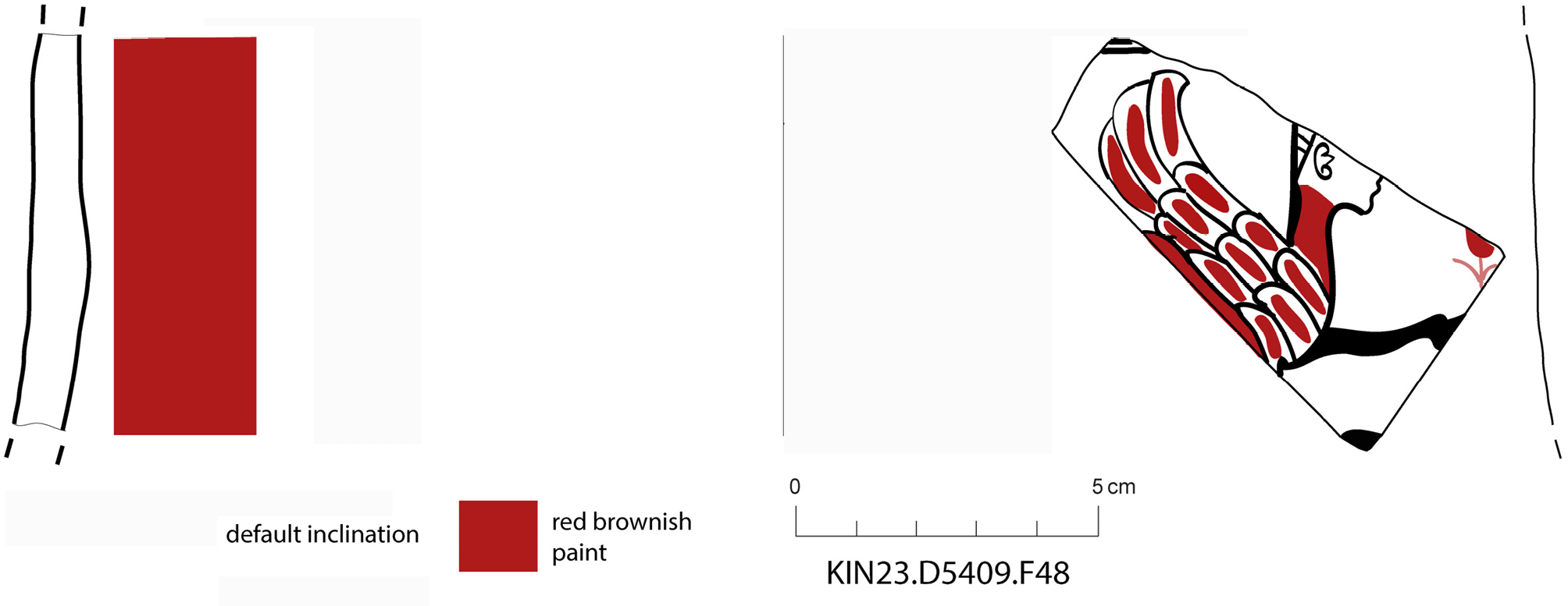
While the sphinx is not fully preserved, it is possible to make out the head, which has feminine features and short hair, the long neck; one of the two front legs raised, the wing, and a portion of what appears to be a flower positioned at the front. In the upper section, a small area with two horizontal lines is visible, while in the lower section, a thicker line potentially identifiable as a band seems to frame the depiction. The depiction is painted in two colours, black and red, on a cream/white slip surface.
A solid red paint outlines the sphinx’s neck, stopping at the jaw and leaving the rest of the face outlined only in black. The wing’s feathers, on the other hand, are characterised by simple, direct red brushstrokes. The leg is painted in solid black. It can be deduced that the body was intended to be painted red, like the neck.
Sphinxes with this design are uncommon in Anatolia. While Achaemenid sphinxes share the position of the front paw raised with KIN23D5409F48, they are characterised by a male head, bull’s ears, long hair and a long beard (Sharifzadeh, Moghaddam 2018: 62). At least one signet ring from Sardis (early 5th century BC) features this iconography (Cahill 2010: cat. 195). Some depictions of sphinxes painted on pottery from Sardis are also defined as belonging to the so-called ‘Wild Goat Style’ and are dated between the late 7th and mid-6th centuries BC. Despite some similarities, such as the use of black and red two-colour painting and the absence of colour in some parts of the body, as in KIN23D5409F48, the overall composition is different. This is evident from the absence of the raised front paw and the rendering of the fur with small dots (Ramage et al. 2021: cat. HoB 597).
The closest parallels to KIN23D5409F48, both in terms of composition and style, are found in Corinthian production during the Orientalising period (late 7th - early 6th century BC). The employment of black and red two-colour painting is a common element, and in numerous examples, the colours are utilised to cover the entire neck and head, while the feathers on the wings are frequently rendered in alternating colours. In a similar manner, the legs are frequently characterised by a complete absence of pigmentation. In certain instances, the facial features are rendered entirely white, an attribute that is evident in the painted embellishments of melia amphorae (Cook and Dupont 2003: 106-108). The rendering of the ear, which in the case of KIN23D5409F48 is depicted without an earring, in contrast to the numerous sphinxes with female features that are shown with an earring, is strikingly similar. The plant element is present in compositions of facing sphinxes, and the pose of sphinxes with raised paws in relation to plant elements is present in the Orientalising period, around the 7th century BC (Kourou 2011: 173-174). This type of composition originated in Syria and has been present in the figurative repertoire since the 8th century BC (Bosana-Kourou 1979: 167). The short hair of KIN23D5409F48 may be indicative of the presence of a headdress or helmet, as evidenced in certain depictions.
It can be hypothesised that KIN23D5409F48 is a probable import, on account of its extremely fine fabric, which is dissimilar to the rest of the fabrics from the same period and exhibits characteristics consistent with the Corinthian orientalising production style.
7b. Zooarchaeology
The Late Iron Age (LIA) faunal assemblage (Phase 3) is the largest and most taxonomically diverse dataset recovered at Kınık Höyük. Domestic species dominate the assemblage, with caprines (sheep-goat) remains forming the numerical majority, followed by cattle and pigs. Cattle contribute a disproportionately high share of the assemblage by weight, underlining their importance in meat provisioning and possibly secondary exploitation (Table 6). In contrast to earlier phases, Phase 3 exhibits a broader range of exploited fauna. In addition to domestic livestock, a range of wild taxa is represented, including hare, land tortoise, stone marten, birds, and fish (Table 6). This diversity indicates a broad-spectrum subsistence strategy that extended beyond routine pastoral exploitation during the LIA.
| Taxa | NISP | %NISP | Weight (g) | %Weight |
|---|---|---|---|---|
| Mammal (cattle-size) | 90 | 12.50 | 1296 | 24.25 |
| Mammal (sheep-size) | 456 | 63.33 | 1749 | 32.72 |
| Mammal (indet.) | 78 | 10.83 | 90 | 1.68 |
| Bos taurus – cattle | 23 | 3.19 | 1086 | 20.32 |
| Ovis aries – sheep | 33 | 4.58 | 504 | 9.43 |
| Capra hircus – goat | 7 | 0.97 | 100 | 1.87 |
| Caprine – sheep/goat | 15 | 2.08 | 130 | 2.43 |
| Sus domesticus – pig | 6 | 0.83 | 119 | 2.23 |
| Equus caballus – horse | 4 | 0.56 | 252 | 4.71 |
| Lepus europaeus – hare | 2 | 0.28 | 3 | 0.06 |
| Canis familiaris – dog | 1 | 0.14 | 6 | 0.11 |
| Martes foina – marten | 2 | 0.28 | 6 | 0.11 |
| Gruiformes – meat providing terrestrial bird | 1 | 0.14 | 1 | 0.02 |
| Testudo graeca – land tortoise | 1 | 0.14 | 3 | 0.06 |
| Cyprinidae – carp-like fish | 1 | 0.14 | 0.3 | 0.01 |
| Total | 720 | 100 | 5345.3 | 100 |
Butchery marks are extensive and widespread across the assemblage. Cattle, caprine, and pig bones frequently exhibit slicing, chopping, and bash marks associated with skinning, disarticulation, and marrow extraction. Processing intensity is particularly high, reflected in the high degree of fragmentation among sheep-sized mammals.
Equid remains show unequivocal evidence of anthropogenic modification. Horse and donkey bones, including long bones, ribs, astragali, and scapulae, bear deep slicing and heavy chopping marks, consistent with systematic carcass processing (Fig. 41). These modifications provide strong evidence for hippophagy during the LIA.
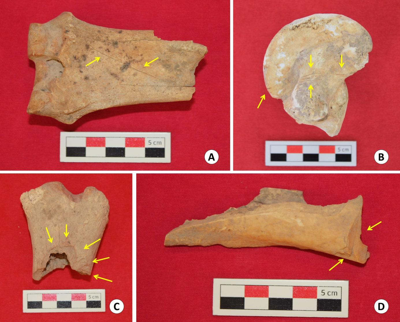
Dog remains, though few, are notable. Evidence for possible cynophagy is limited but notable. Particularly, several dog long bones exhibit extensive slicing marks (KIN21D4313s13). A lightly burned dog baculum (KIN23D5421s25) may also reflect consumption, although alternative explanations such as post-depositional burning or non-dietary use cannot be excluded (Fig. 42). However, the pattern is most consistent with occasional cynophagy, particularly given the broader pattern of intensive butchery observed across taxa (Fig. 43).
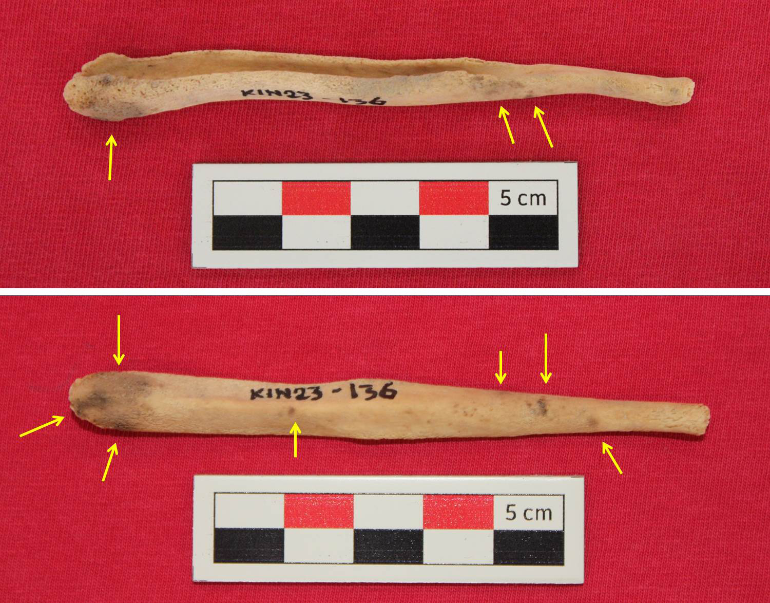
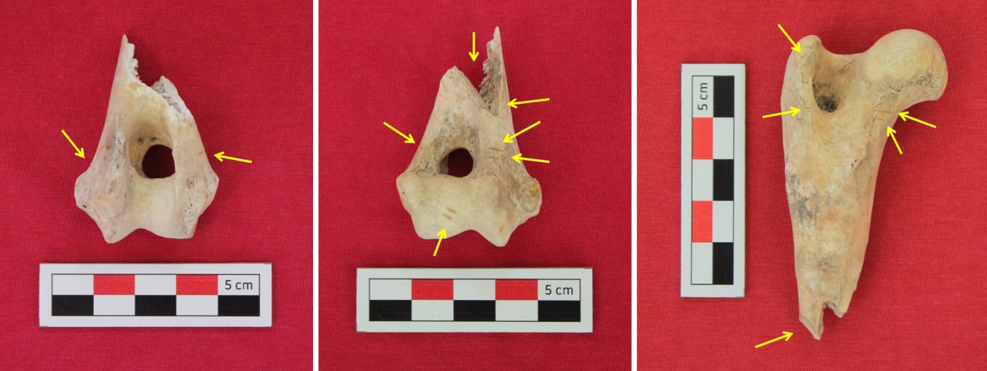
Burning is generally rare across the assemblage and appears incidental rather than systematic. In contrast, extensive carnivore gnawing particularly on cattle bones is a recurring feature, indicating post-discard exposure prior to deposition. Conversely, the limited evidence of weathering suggests relatively rapid burial of the overall faunal assemblage. Pathological changes are rare but informative. A mid-grade abscess on a sheep mandible and early-stage exostosis and pitting on sheep limb bones point to long-term animal management and stress, consistent with sustained herding practices.
The presence of foetal caprine bones and infant pig cranial fragments provides clear evidence for on-site breeding and herd management. Consumption of very young animals suggests either opportunistic slaughter, mortality management, or specific dietary preferences during this period.
Wild and opportunistically exploited taxa occur regularly in Phase 3. Hare remains display slicing marks, consistent with consumption. A land tortoise shell fragment, a partridge-sized bird ulna, and fish remains point to supplementary exploitation of locally available wild resources. The presence of stone marten bones may represent either incidental capture or limited use of wild carnivores. A rectangular fragment of deer antler bearing chopping marks on all sides indicates antler working, likely related to tool or object manufacture rather than food consumption.
Zooarchaeological evidence from Phase 3 indicates a highly dynamic and flexible subsistence system dominated by pastoral production but regularly supplemented by wild game and unconventional food sources. Cattle and caprines remained the economic foundation; however, the systematic butchery of horses, donkeys, and dogs distinguishes this phase from both earlier and later periods, providing clear evidence for hippophagy and occasional cynophagy. The high frequency of butchery marks, the exploitation of a broad taxonomic range, and the adoption of unconventional dietary practices suggest either increased occupation intensity or shifts in the social and economic conditions at Kınık Höyük during the LIA.
7c. Paleoethnobotany
Paleoethnobotanical analyses were conducted on four samples from Phase 3, all originating from secondary deposits, including fills of pits (KIN21D4346s88; KIN21D4344s79) and the ovoid installations (KIN21D4380s166, KIN23D4390sNR; Phase 3a) (Table 9, available online in supplementary material). The concentration of botanical macro-remains is low, with charcoal fragments larger than 2 mm amounting to 0.153 g/L, alongside 12 economic seeds/fruits and 26 from wild or weedy taxa.
Wood charcoal larger than 4 mm was retrieved from KIN21D4344s79 and KIN23D4390sNR. As in previous phases, deciduous oak is dominant (18 fragments), while other taxa are represented by single fragments: Chenopod family (Chenopodiaceae; 1 fragment), juniper (Juniperus sp.; 1 fragment), Scots pine type (Pinus sylvestris-type; 2 fragments), and willow/poplar (Salicaceae; 1 fragment).
The carpological record mirrors the range of economic taxa identified in earlier phases, though only in single finds. Hulled barley (Hordeum vulgare; 4 grains) and free-threshing wheat (Triticum aestivum/durum; 3 grains) are present, together with pulses represented by lentil (Lens culinaris; 1 cotyledon) and bitter vetch (Vicia ervilia; 2 seeds). Fruit and nut taxa are also attested, with grapevine (Vitis vinifera; 2 seeds) and a mineralized nutlet of hackberry (Celtis sp.). Wild and weedy taxa are again represented by isolated occurrences of field weeds, including Lithospermum/Arnebia, Brassicaceae s.l., Vaccaria pyramidata, Suaeda sp., Carex sp., Medicago sp., Trigonella sp., Ajuga/Teucrium, Glaucium sp., Poaceae s.l., Adonis sp., and Hyoscyamus sp. As in the preceding phases, the overall low counts do not allow for meaningful quantitative assessment.
A note should also be made of the abundant presence of amorphous charred substance in sample KIN23D4390sNR, originating from the fill of a Phase 3a ovoid installation. Considering the presence of production slags in these structures (see next section), it is likely that these clots are linked to the artisanal activities carried out there. Proper identification will require further study using a scanning electron microscope (SEM).
7d. Production Waste (Metal and Glass)
During the 2023 excavation campaign, a subset of slag samples from Area D was examined to establish a site-specific typology that can be used in future analyses to aid interpretation of the function of Area D during Phase 3. The methodology comprised macroscopic inspection of exterior surfaces and fresh fracture faces, metric recording, and photography.
The slags can be grouped into four broad types:
1.Melted and vitrified slag. Extremely porous, with a black to greenish colour; mineral fragments are visible on fresh fractures (Fig. 44).
2.Iron(-rich) slag. Metallurgical slag fragments with generally low porosity and an orange fabric (Fig. 45).
3.Burnt brick with adhering viscous slag. Clay bricks showing burning on one face and a film or globules of viscous, vitrified slag fused to the other; macroscopically comparable to the “melted and vitrified” slag described above.
4.Slag from glass production (provisional). Light, small, droplet-shaped pieces consistent with glass working by-products (Fig. 46).
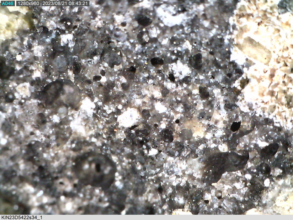
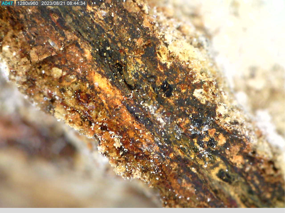
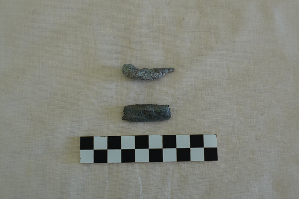
The majority of slags (Fig. 47) belong to the first and third types, whereas the second and fourth are rarer. All samples were recovered from the fillings of ovoid pits containing ashy sediments and associated debris. These pits occur in the earlier part of Phase 3 (Phase 3a). A plausible explanation is that the burnt bricks and vitrified slags derive from fire installations that were demolished during the subsequent reorganisation of the settlement (Tab. 7).
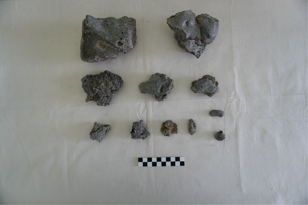
| Sample number | SU | Quantity | Weight | Slag type | Ph |
|---|---|---|---|---|---|
| KIN23D5419s22 | 5419 | 1 pcs. | 47 gr. | molted and vitrified slag | 3b |
| KIN23D5419s32 | 5419 | 1 pcs. | 8 gr. | slag from glass production | 3b |
| KIN23D5420s31 | 5420 | 6 pcs. | 58 gr. | 5 pcs. of burned bricks 1 pcs. of molted and vitrified slags |
3b |
| KIN23D5420s27 | 5420 | 1 pcs. | 34 gr. | molted and vitrified slag | 3b |
| KIN23D5422s34 | 5422 | 12 pcs. | 1508 gr. | 1 pcs. of iron slag 4 pcs. of burned bricks 7 pcs. of molted and vitrified slags |
3a |
| KIN23D5422s33 | 5422 | 2 pcs. | 8 gr. | 2 pcs. of slag from glass production | 3a |
| KIN23D5429s47 | 5429 | 10 pcs. | 152 gr. | 2 pcs. of burned bricks 8 pcs. of molted and vitrified slags |
3b |
| KIN23D5429s45 | 5429 | 9 pcs. | 440 gr. | 2 pcs. of burned bricks 7 pcs. of molted and vitrified slags |
3b |
| KIN23D5429s69 | 5429 | 1 pcs. | 52 gr. | molted and vitrified slag | 3b |
| KIN23D5429s68 | 5429 | 1 pcs. | 120 gr. | molted and vitrified slag | 3b |
| KIN23D5429s24 | 5429 | 1 pcs. | 332 gr. | molted and vitrified slag | 3b |
| KIN23D5431s54 | 5431 | 7 pcs. | 307 gr. | 7 pcs. of molted and vitrified slags | 3a |
| KIN23D5440s62 | 5440 | 1 pcs. | 4 gr. | molted and vitrified slag | 3a |
In conclusion, the data tentatively indicate the presence of an atelier/workshop, possibly polyfunctional (glassworking and metallurgy), located in the northern part of the area. The various deposits yielding slags would then represent levelling and clearance episodes following the demolition of this facility as part of the Phase 3 reconfiguration of the Lower Town. To test this hypothesis and clarify the nature of the atelier, mineralogical and chemical analyses of the samples are required.
7e. Local Pottery from the installations’ filling (Phase 3a)
The ceramic assemblage presented here (Figs 48-49) for this phase represents a selection of material examined within the framework of a Master’s thesis, which focused on the ceramics from the stratigraphic units associated with the fills of the ovoid installations, particularly the southernmost ones. The selection offered in this report is intended to provide a preliminary overview of the assemblages, with the specific aim of suggesting a chronological placement for the disuse phase of the ovoid installations. It should be stressed that the material employed to fill these features most likely derives from a levelling process involving nearby deposits, as already indicated above, in connection with the wider reorganization of the area that becomes fully evident in Phase 2.
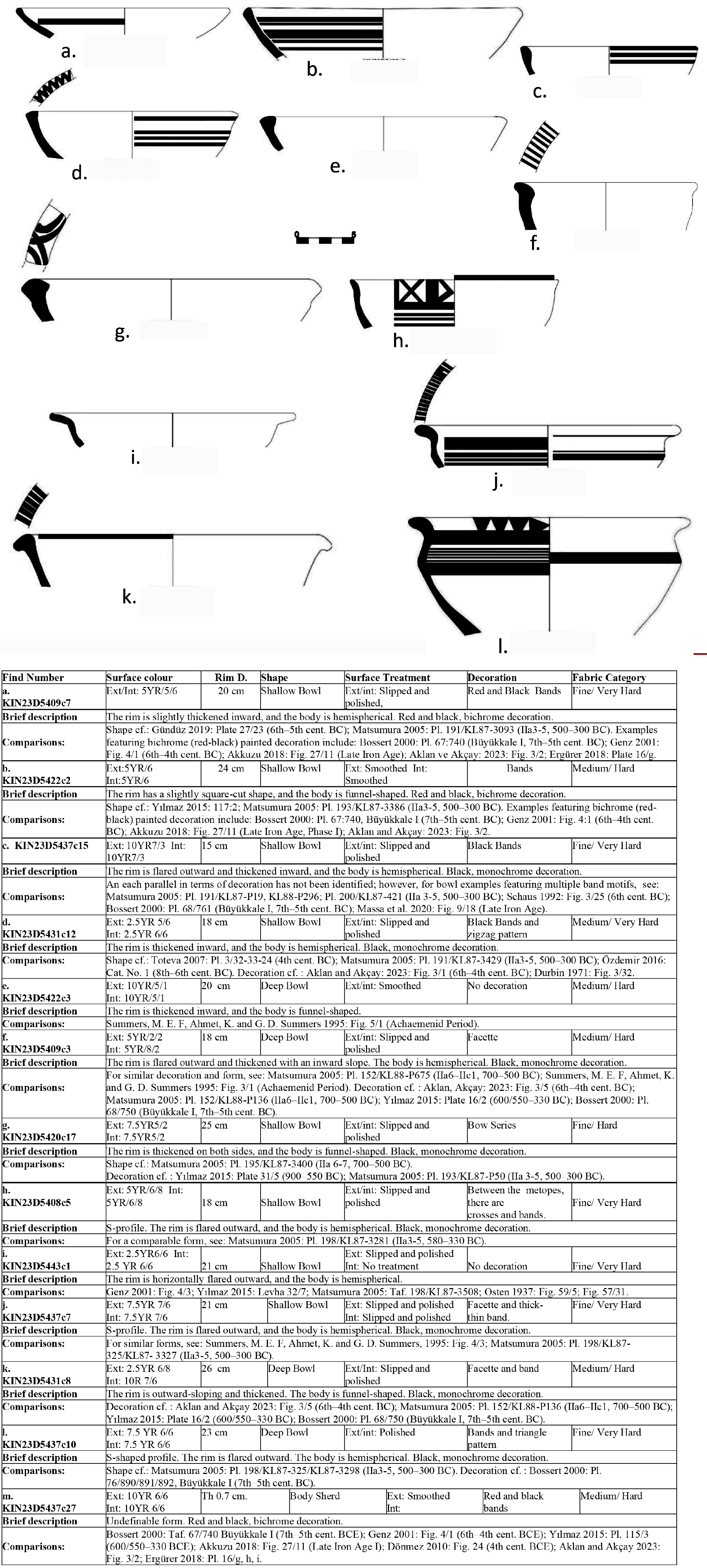
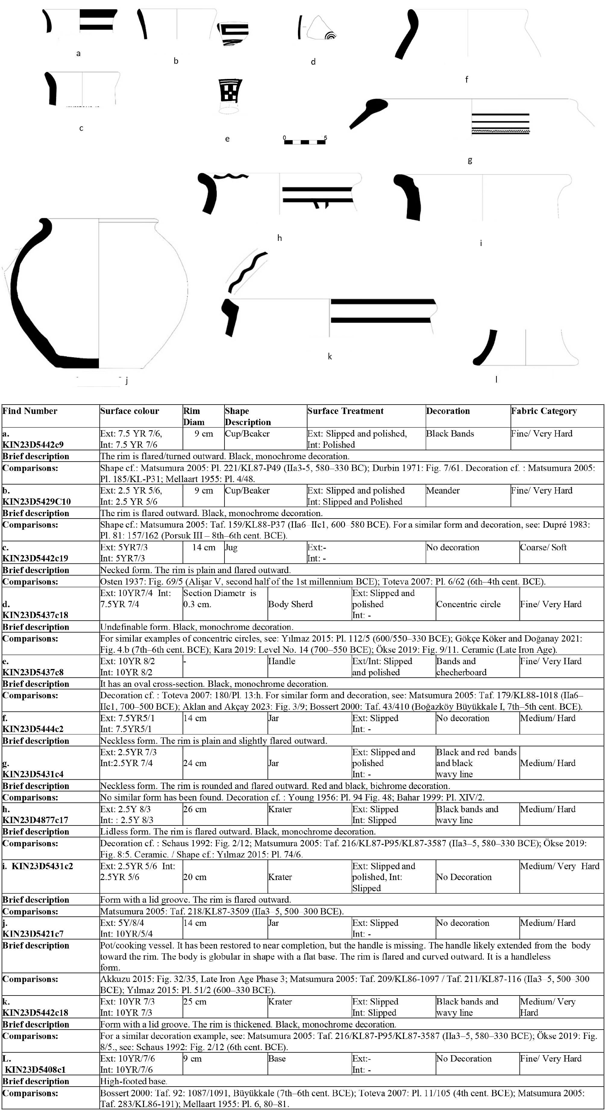
Bowls: in this study, eight shallow bowls have been evaluated (Fig. 48a-d; g-j). Although the form types do not indicate mass production, they have been internally classified according to rim typology. The evaluated examples show typological similarities to LIA forms identified at settlements such as Çadır Höyük, Oymaağaç Höyük, Alişar Höyük, Tilkigediği Tepe, Gökhöyük Bağları Höyüğü, Gordion, and Türkmen-Karahöyük (see references in the fig.). On the other hand, comparison of decorative elements reveals that typical Iron Age decorative patterns were preferred, such as facetted rim (KIN23D5437c7, Fig.48j), zigzag sequences on the rim (KIN23D5431c12, Fig. 48d), and horizontal bands on the body (KIN23D5422c2, Fig. 48b). While the precise origins of these decorative types remain unclear, comparative analyses suggest a shared repertoire within the ceramic decorative tradition of Central Anatolia. Among the evaluated shallow bowl examples, one particularly notable decorative feature is the use of an X motif placed between metopes (KIN23D5408c5, Fig. 48h). The closest parallel to this motif has been observed in Level I at Büyükkale, dated to the 7th–5th centuries BC (Bossert 2000: pl. 43/405). Additionally, an increased use of red paint in decoration during the LIA has been noted (Kealhofer and Grave 2011: 421), that is also clearly visible in the Kınık Höyük assemblage (KIN23D5422c2 Fig.48b). The other bowl forms evaluated in this study are deeper in profile compared to the shallow bowls and are generally thought to have been used for the consumption of liquid foodstuffs (Matsumura 2005: 153). These vessels predominantly feature thickened rim types, indicating a preference for such forms in their production. Comparable typological examples have been documented at sites such as Kaman, Tilkigediği Tepe, Oymaağaç Höyük, Büyükkale, Ovaören-Yassıhöyük, various small mounds identified during survey work conducted in the Konya region, and Türkmen-Karahöyük (see references in the catalogue). In terms of decoration, one of the most prominent features observed is the facetted rim motif, which is characteristic of Iron Age ceramic ornamentation. Among the deep bowls, one particularly notable example is the vessel numbered KIN23D5437c10 (Fig. 48l), distinguished by its S-shaped profile and carefully executed decorative scheme. A sequence of triangles is observed on the upper section of the rim, while the lower portion is decorated with thick and thin bands. In terms of decorative correlation, this vessel represents a unique example among the ceramic finds retrieved from the ovoid installation in Sector D. Similar parallels have been identified in Level I of Büyükkale, dated to the 7th–5th centuries BC (Bossert 2000: pl. 76/890/891/892). Among the shapes from this assemblage, cups/small jars (Fig. 49a-c) represent the rarest type, with only two examples evaluated in this study. One of them is decorated with the typical horizontal band motif, while the example KIN23D5429c10 (Fig. 49b) stands out for its use of a meander-like pattern. A closely comparable example of this decorative motif has been identified in Phase III at Porsuk Zeyve Höyük (see Dupré 1983: pl. 81: 157/162). Only a single jug has been evaluated in this study. Typically produced as a liquid container, comparable examples of this form have been identified at Alişar Höyük and Gordion. Decorations are generally not preferred in this kind of vessel type.
Cooking pot: three jar forms have been evaluated, two of them bearing burn marks on the exterior surfaces (KIN23D5421c7 and KIN23D5444c4). The jar/pot KIN23D5421c7 (Fig. 49j) is particularly significant due to its near-complete restoration and represents a typical cooking pot form for Kınık Höyük in LIA. Comparable examples have been documented at Kaman and Oymaağaç Höyük. The presence of this shape type as far as the Black Sea region (e.g., Oymaağaç Höyük, Samsun, see ref in Fig. 49) is noteworthy. In contrast to the other two examples, the jar KIN23D5431c4 (Fig. 49g) does not exhibit any evidence of use for cooking purposes, rather it is decorated with horizontal bands and a wavy motif applied over a white slip. This type of wavy motif is particularly attested during the Iron Age, especially at Gordion.
In this study, a total of three specimens of krater has been examined (Fig. 49h-k), two of them showing an indented rim profile, probably for a lid. These kraters belong to a type of vessel that was commonly used in Central Anatolia during the LIA, primarily for wine serving. Although some examples from this period feature rather large rim diameters, the ones discussed here represent medium-sized forms that were likely produced for domestic use. When similar examples from Central Anatolia during the LIA are taken into consideration, it is observed that wave motifs were frequently used along the rim sections. The wave decoration observed on the rims of the krater samples numbered KIN23D4877c17 and KIN23D5442c18 (Fig. 49k) shows parallels with comparable forms and decorative elements found in Gordion, Kaman, and various mounds in the Sivas region. In particular, the fact that the KIN23D5442c18 specimen closely resembles examples from Gordion (Schaus 1992: fig. 2/12) in terms of both form and decoration is significant, as it serves as tangible evidence of cultural interaction among settlements. One high-footed base and one handle fragment of unidentified vessel form have been examined. The high-footed base is thought to belong to a goblet-type form. Similar examples have been found at Büyükkale, Gordion, and Kaman. Although the exact vessel form to which the handle fragment belongs could not be determined, it is noteworthy that the checkerboard motif seen in its decoration was commonly used on handles, bodies, and rim sections of various vessel types during the Iron Age in Central Anatolia. Comparable examples have been identified at Gordion, Kaman, Ovaören-Yassıhöyük, and Büyükkale. Although the vessel forms to which the examined body sherds belong could not be identified, as previously mentioned, (like KIN23D5422c2) the sample KIN23D5437c7 features a polychrome decoration that became increasingly common during the LIA. In KIN23D5437c18 (Fig. 49d), a concentric circle motif primarily known from Level IV at Alişar is observed. Comparable examples of this concentric circle motif from the LIA have been found at Oymaağaç Höyük, Cicek Höyük, Ovaören-Yassıhöyük, and various mounds in the Sivas region (see ref. in the fig.).
8. The Hellenistic Lower Town (Phase 2)
8a. The passage from Late Iron to Hellenistic Period (2b)
Phase 2 has been subdivided into two sub-phases, 2a (later) and 2b (earlier). The distinction is primarily chronological, although in the archaeological deposits of Area D only Phase 2a is securely attested. Phase 2b, by contrast, appears to be largely absent from the record.
The hypothetical Phase 2b is defined essentially as a possible hiatus in the occupation of the Lower Town. The ceramic assemblages recovered from the fills of the ovoidal installations and from the deposits that sealed them (Phase 3a) consistently point to a chronological horizon closing at the end of the 6th century BC and the very beginning of the 5th century BC. No diagnostic markers attributable to the so-called Achaemenid period were identified in this sector, leaving a chronological gap between the end of the LIA and the beginning of the Hellenistic period, which is the next phase securely attested. For this reason, Phase 2b is interpreted as a period of non- use of the area, at least in this portion of the Lower Town.
8b. The Hellenistic reoccupation (2a)
Phase 2a, by contrast, is archaeologically attested (Fig. 50), especially in the western part of the excavation area. The evidence points to a major intervention aimed at reorganizing the space: the levelling of the surface to create a more regular topography, accompanied by the construction of small terracing walls. These were clearly intended both to control the residual slope of the terrain and, plausibly, to delimit the extent of the occupied area during this phase. The most distinctive architectural feature of Phase 2a is represented by an irregular “serpentine” wall (D4304, D4868, D4907, D5434), which does not appear to belong to a building but is more plausibly interpreted as a terracing wall (Figs 51-52). In plan, the wall shows a markedly irregular course: it runs NE–SW in its southern portion, then curves to the north, and finally bends again towards the NW before disappearing beneath the limits of excavation. In this sector, the wall lies directly below the topsoil, and its state of preservation is largely determined by its shallow position. It is built of medium-sized stones, with some larger blocks deliberately included. Notably, these larger stones are concentrated in the area of the ovoidal pits that had previously cut through the MBA fortification wall; it is therefore plausible that some of the blocks used in the construction of the “serpentine” wall were reemployed from stones removed during the installation of the Phase 3b pits. The wall is preserved up to two courses in height. The associated walking surface is clearly identifiable to the south and west of the preserved section, while it is less visible to the north and east and it follows the same slope as in the previous phase.
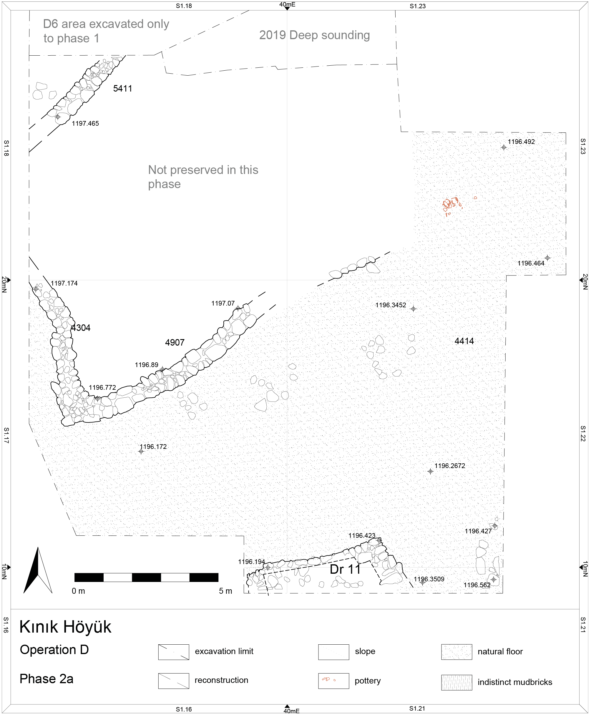
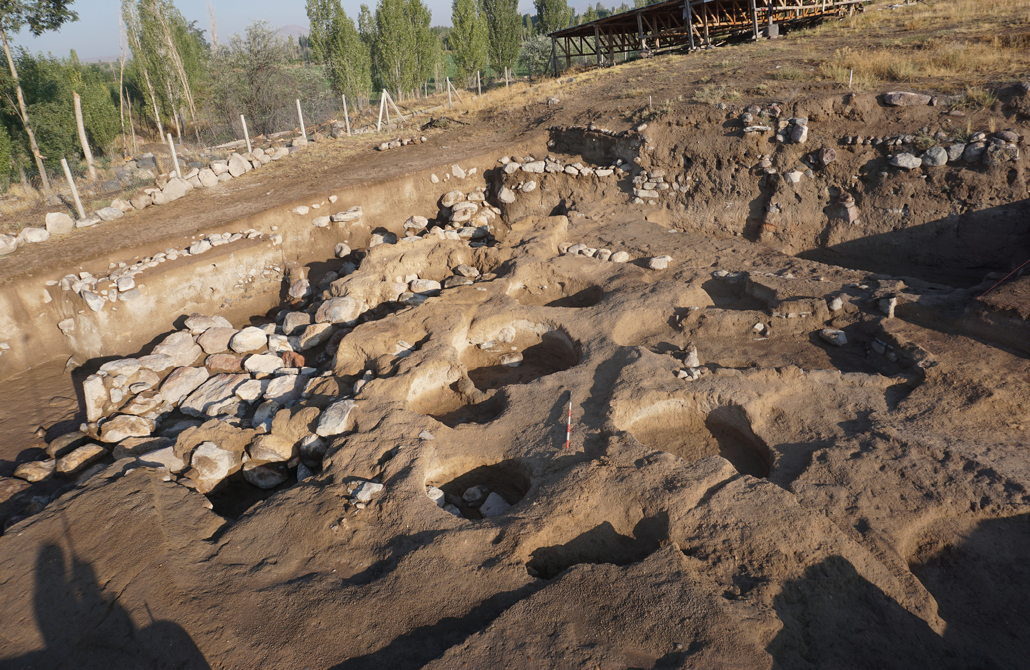
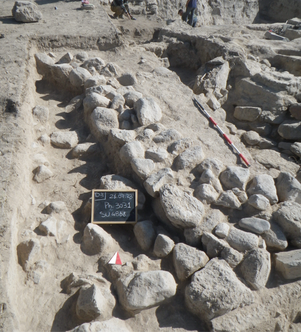
In the northern part of the area, a further wall (D5411) was uncovered, running on a NE–SW alignment. Built of medium-sized stones and preserved for two courses, it shares both construction technique and elevation with the so-called “serpentine” wall. Since only a limited stretch was exposed, however, it remains unclear whether this feature originally joined the “serpentine” wall to form a corner or belonged to an independent structure, as the potential junction lies beyond the excavated area. However, unlike to the south, where a related floor surface was clearly identified, the higher, north-facing surface is not preserved, likely because it was removed during modern interventions in this area (see above).
To the south of the “serpentine” wall, where the floor surface (D4909) is clearly preserved, two additional features were identified. The SW feature corresponds to the corner of a room, designated Dr11 (D5274, D5290, D5293, D5294, Fig. 51), built with rather makeshift walls of medium- and small-sized stones, carefully aligned on the exterior face but poorly finished on the interior. Within the limited portion of the room exposed by excavation, several fire installations (D5296, 5295) were identified, constructed with medium-sized stones arranged in circular settings and occupying much of the preserved space. Notably, a significant number of iron tools were recovered from within this structure, strongly suggesting that the room was also used for craft-related activities. Among these we may mention an iron tool head (KIN24D5291F15) and some iron nails (KIN24D5291F16). In contrast, the installation (D5285) located in the SE corner of the excavation area is less clear. Only a small portion of it has been exposed, revealing part of a circular feature built of stone. However, due to the very limited extent of its exposure, its function remains uncertain at present. Few shallow pits (D4303 and D4316) were found close to the “serpentine” wall.
8c. Faunal Remains
The faunal assemblage from Phase 2a is limited in size but provides a preliminary view of animal exploitation at Kınık Höyük during the Hellenistic period. The assemblage is dominated by sheep-sized mammals, with caprines and cattle representing the principal domestic taxa. Pig occurs in very small numbers, and may indicate only minor contributions during this period (Table 8). Wild taxa are minimally represented, with a single hare bone recorded.
| Taxa | NISP | %NISP | Weight (g) | %Weight |
|---|---|---|---|---|
| Mammal (cattle-size) | 9 | 11.11 | 78 | 17.28 |
| Mammal (sheep-size) | 54 | 66.67 | 160 | 35.45 |
| Bos taurus – cattle | 4 | 4.94 | 102 | 22.60 |
| Ovis aries – sheep | 8 | 9.88 | 72 | 15.95 |
| Capra hircus – goat | 1 | 1.23 | 9 | 1.99 |
| Caprine –sheep/goat | 3 | 3.70 | 29 | 6.42 |
| Sus domesticus – pig | 1 | 1.23 | 1 | 0.22 |
| Lepus europaeus – hare | 1 | 1.23 | 0.4 | 0.09 |
| Total | 81 | 100 | 451.4 | 100 |
Fragmentation is high, particularly among ribs and vertebrae of sheep-sized mammals, suggesting intensive processing and post-depositional disturbance. Despite its modest size, the assemblage is consistent with domestic refuse derived from food consumption activities.
Butchery marks are present on both cattle and caprine bones and include slicing and chopping traces associated with disarticulation and meat removal. Light burning marks occur on several specimens, including a cattle centrotarsal and pig rib, suggesting exposure to hearths or cooking-related activities. Extensive gnawing, particularly on cattle and caprine bones, indicates post-discard access by carnivores or scavengers. These taphonomic features collectively point to secondary deposition of household waste, rather than structured disposal or specialized activity areas.
The Phase 2a assemblage reflects routine domestic consumption practices, centered on caprine and cattle exploitation. The low representation of pigs and wild animals may reflect either genuine dietary preferences or sampling bias caused by the small assemblage size. Although the faunal remains are few, they indicate continued reliance on domestic livestock, particularly sheep-goats and cattle. Given the limited dataset, broader interpretations concerning herd management strategies, seasonal practices, or dietary diversity remain tentative. Future excavation and recovery of larger faunal assemblages will be essential to assess more fully the complexity of animal economy and subsistence strategies during the Hellenistic period at Kınık Höyük (Fig. 53).
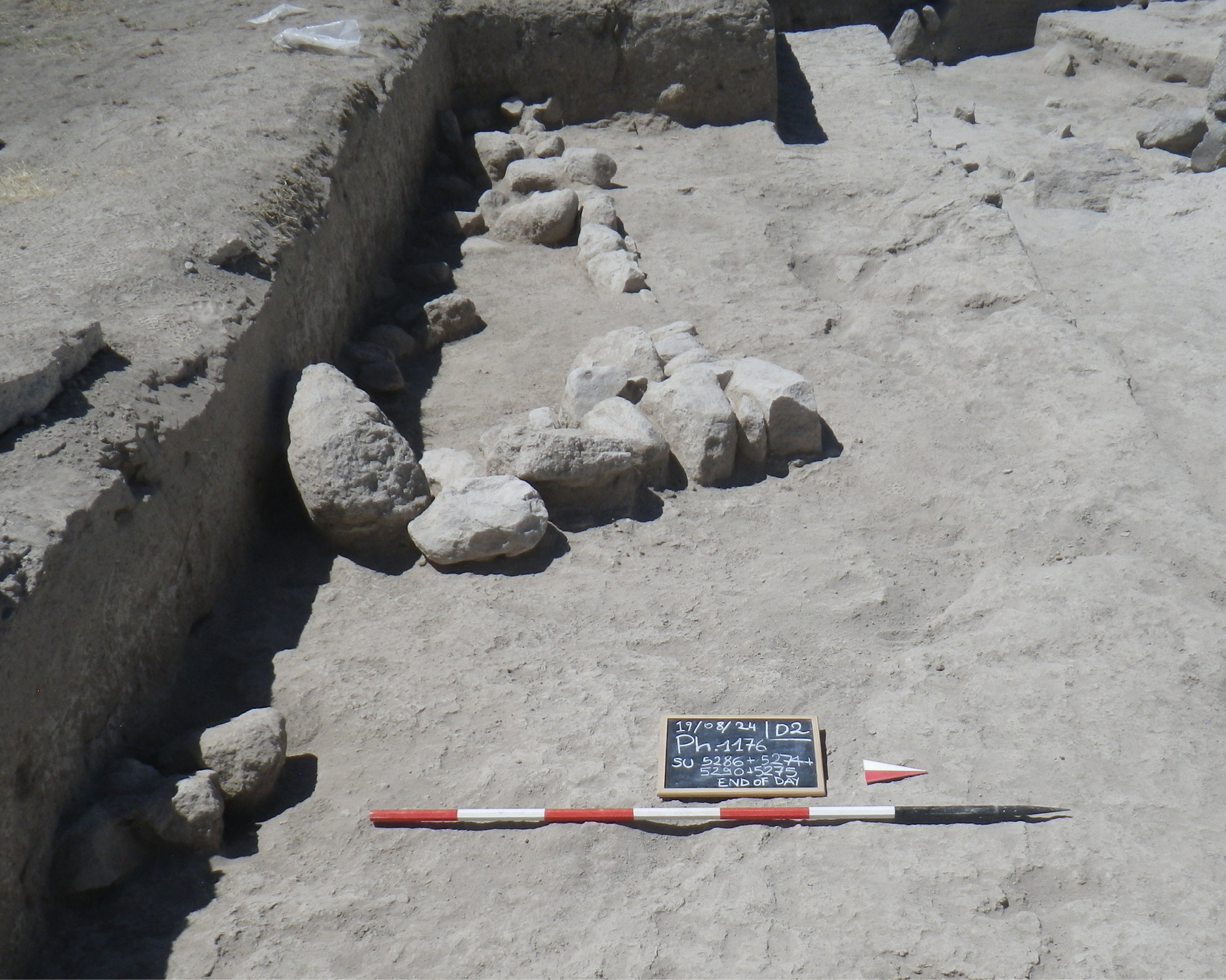
8d. Paleoethnobotany
Paleoethnobotanical analyses were conducted on three samples that may be attributed to Phase 2: KIN21D4327s93, KIN19D3310s117, and KIN22D4437s40 (Table 9, available online in supplementary material). The dating of the latter two to the Hellenistic period remains tentative. As in the earlier deposits, concentrations of plant macro- remains are particularly low, with charcoal fragments larger than 2 mm amounting to 0.074 g/L, two economic seeds, and 61 wild or weedy specimens. The wood charcoal assemblage consists of deciduous oak (Quercus sp. deciduous; 3 fragments), grapevine (Vitis vinifera; 2 fragments), juniper (Juniperus sp.; 5 fragments), an indeterminate conifer (2 fragments), and an indeterminate taxon (1 fragment).
In the carpological record, economic taxa are restricted to two grains of hulled barley (Hordeum vulgare). The wild and weedy component is more diverse, including Lithospermum/Arnebia (1 charred, 94 uncharred nutlets), Suaeda sp. (4 seeds), Carex sp. (3 achenes), Fimbristylis sp. (48 charred, 42 uncharred achenes), Trifolieae (2 seeds), Poaceae s.l. (1 caryopsis), and Tribulus terrestris (1 uncharred mericarp).
All uncharred specimens originate from sample KIN22D4437s40. Tribulus terrestris is likely a modern contamination, as its spiny mericarps often cling to clothing. In contrast Lithospermum/Arnebia and Fimbristylis sp. are preserved through natural mineralization. Both are bio-mineralizing plants, producing hard, mineral-rich fruits that can survive uncharred in archaeological deposits. As noted by Pustovoytov et al. (2004), the chronological attribution of such bio-mineralized remains must be assessed on a case-by-case basis, since their intrusive nature cannot be ruled out.
9. Post Hellenistic? Roman (Phase 1)
Phase 1 was clearly identified only in the northernmost part (D6) of the excavation area, which was opened as part of a broad trench designed to connect sectors D2 and D5 with sector D1, investigated between 2013 and 2019. This newly explored zone directly adjoins the 2019 sounding north of D2 and is particularly significant in that it has not been affected by the recent mechanical removals that impacted much of Area D. As a result, it preserves the complete stratigraphic sequence of the Lower Town. At present, excavation has reached only the most recent occupation levels immediately below the topsoil (Fig. 54). However, the north section of D2–D5 makes it possible to reconstruct the relationship between these Phase 1 remains and the earlier phases exposed elsewhere in the area. The investigated sector is narrow – corresponding to the 15 m width of D2–D5 – and extends only 2–3 m in depth NS, following the natural slope of the hill.
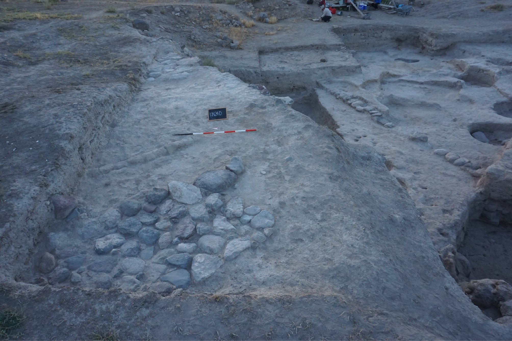
Within this sector, the clearest architectural evidence is a stone-paved surface (D5265), aligned SE–NW, which appears to represent the paving of a broad street. This feature was bounded to the east by a mudbrick wall (D5264), while at the extreme eastern edge of the sector another concentration of stones (D5258) was exposed. Due to the limited extent of excavation, it remains unclear whether this latter feature formed part of the same paved street or belonged to a separate architectural structure.
From an interpretative standpoint, the presence of the stone-paved surface suggests the layout of a major thoroughfare within the Lower Town, possibly one of the principal axes that structured the circulation of this sector of the settlement. Its orientation and substantial width, combined with the flanking mudbrick wall, point to a deliberate urban arrangement, further underlining the importance of this northern area for understanding the organization of the later phases of occupation.
The absolute dating of these structures remains problematic, since the associated material derives directly from contexts located immediately beneath the topsoil and thus provides little chronological reliability. What can be stated with certainty is that they are stratigraphically later than both the Phase 2 features described above and the evidence uncovered in 2019 in sector D1. Within this framework, a tentative attribution to the Roman period has been proposed, based on a very limited number of finds recovered in the southern portion of the excavation area (D2–D5). This phase appears to be represented primarily by cuts and removals rather than coherent architectural remains. In particular, a large pit identified in the eastern part of sector D2 yielded fragments of glass (KIN23D5217F12) datable to the Roman period, together with no later material, suggesting that the area may have undergone disturbance either during this phase or shortly thereafter. Further expansion of the excavation northwards, already planned for the coming years, will allow us to clarify the nature of this phase, which currently appears to represent the final stage of urban occupation in the SW sector of the Lower Town.
10. Discussion
The evidence presented from Area D allows a reassessment of the long-term occupation history of the Lower Town at Kınık Höyük , highlighting a sequence marked by pronounced discontinuities rather than linear development. The stratigraphic, ceramic, and radiocarbon data point to alternating phases of intensive use, contraction and reorganisation. Rather than reflecting a continuous urban trajectory, the Lower Town emerges as a space repeatedly redefined in response to broader political, economic and infrastructural shifts in southern Cappadocia, from the MBA to the Hellenistic period. The following discussion examines these dynamics through patterns of continuity and discontinuity in material culture and urban layout, situating the Kınık Höyük sequence within the wider Anatolian and eastern Mediterranean context. Against this broader framework, a first issue concerns the questions of the initial foundation of the Lower Town. It remains an open issue when the Lower Town of Kınık Höyük was actually founded. Earlier publications (Highcock, Matessi 2021) did report the identification of one context of approximately 40 ceramic sherds datable to the Early Bronze Age and related to a surface reached only in a very limited test sounding (deep trench in D, between D6 and D2) . We can therefore state only that an Early Bronze Age occupation is possible, but we cannot ascertain that this part of the Lower Town was occupied during this period. This hypothesis can be verified only when architecture and contexts attributable to that phase are exposed beneath the MBA levels.
10a. The Lower Town from the Middle Bronze Age to the Hellenistic period: continuity and discontinuity in ceramic production
Establishing lines of continuity in the material culture is inherently difficult, given the hiatuses and the uneven nature of the deposits. In our sequence, only the archaeological evidence ascribed to Phase 6 and to Phase 4 provides primary contexts; the remaining phases show largely secondary contexts, and Phase 2 is only sparsely attested in this sector. Within these constraints, some ceramic continuities can nevertheless be observed. Most notably, cooking wares retain a consistent fabric recipe across phases, with variation chiefly in temper grain size. Vessel forms and sizes shift, yet their orientation toward wet cooking persists, indicating a stable culinary practice despite episodic breaks in occupation and changes in architectural setting.
In Phase 6, the ceramic assemblage indicates a MBA II milieu rooted in a strong local tradition, yet also exhibiting clear connections with external repertoires. The “squared” bottle and the grape-cluster vessel sit comfortably within an eclectic MBA II repertoire attested at Acemhöyük and Kaniš/Kültepe, where morphological experimentation coexists with conventional forms. The band-painted scheme (broad red bands over a light ground, especially on open shapes) likewise belongs to the MBA II decorative horizon. Additional echoes in regional assemblages (e.g., kraters/bowls; coarse kitchen wares with similar recipes) suggest that Kınık participates in a South-Central Anatolian stylistic ceramic horizon whose reach also touches major plateau centres, while retaining local solutions in form and finish.
Functionally, the pairing of massive fortification elements with substantial external hearth installations reinforces the impression of a well-integrated MBA urban quarter plugged into these networks.
Despite its limited quantitative representation, the transition from Phase 6 to Phase 5 marks an immediate change in the ceramic forms that characterise this phase belonging to the LBA (see pottery phase 5). The closest parallels for these forms come from Central Anatolia, particularly the Hittite levels at Boğazköy. This is particularly evident in the cordoned external rims and large plates. Similar material has also been found in Levels 4 and 3 at Kayalıpınar, which are dated to the 15th-14th centuries BC. Due to the limited amount of material from Phase 5 in the Lower Town of Kınık Höyük, it is challenging to demonstrate direct Hittite influence or control over ceramic production at this stage. Instead, it can be suggested that there was a general familiarity with the ceramic forms circulating in Anatolia during the LBA. While many common traits are shared by the LBA ceramic repertoire of Central Anatolia and its neighbouring regions, concerning the shapes found in Phase 5, the strongest similarities appear to lie with Central Anatolian sites rather than with those of Cilicia. In fact, in the LBA levels of Kilise Tepe (Postgate and Thomas, 2007), Kinet Höyük (Gates, 2001) and Tarsus (Goldman, 1956), all located in Cilicia, plates often have thickened rims on the inside and are smaller in size than Central Anatolian examples, with diameters generally not exceeding 30 cm. However, also these region seem to follow a general trend of progressive transformation from shallow bowls to plates.
With Phase 4, primary contexts (e.g., Dr7/Dr10) mark a renewed, though architecturally modest, occupation that aligns Kınık with the MIA ceramic horizon of the plateau. Bowls (shallow and deep), kraters (including biconical and amphoroid profiles), and cooking pots show close formal and technological affinities with sequences from Kaman, Boğazköy/Hattusa, Porsuk, Alişar, and Gordion (with further comparisons found at Kuşaklı and at the Cilician/Mid-Anatolian interface at Kilise Tepe/Tarsus). As noted above, the functional emphasis on wet cooking continues; the decorative vocabulary – bands, undulating/zig-zag lines, dotted motifs – fits these comparanda. In short, while the urban fabric does not revert to Bronze-Age monumentality, domestic ceramic practice coheres with the main Central Anatolian MIA horizon: similar clay recipes for kitchen wares, analogous rim engineering on bowls/kraters, and broadly comparable firing/finishing routines.
Phase 3 is more complex because much of the evidence derives from secondary fills (3a) and specialized installations (3b). Even so, two strands of connection are clear. First, the textile toolkit (c. thirty unfired clay loom weights) has close analogies with Sardis (Lydian I, Building D), though the Kınık weights are lighter on average, implying a different yarn/fabric target. Second, specific motifs travel: the reserved cross on a dark ground at the base of the thin-walled bowl/lid finds a pointed parallel at Knossos (Early Greek cemetery), while other bowl morphologies and LIA decorative schemes (facetted rims, zig-zags, banding, “X-between-metopes”) intersect with series documented at Çadır Höyük, Oymaağaç Höyük, Alişar Höyük, Tilkigediği Tepe, Gökhöyük Bağları Höyüğü, Gordion, Türkmen-Karahöyük, and Büyükkale (Level I). Taken together, these links place Kınık within a broader, western-leaning interface in the LIA, where domestic/craft activities and filling/levelling practices incorporate objects and fashions circulating well beyond Cappadocia. Given the non-primary nature of many Phase-3 contexts, these relationships are best read as strong signals of contact and re-deposition rather than direct evidence of on-site production.
10b. From Middle Bronze urbanism to Hellenistic re-foundation: a punctuated history
In MBA Central Anatolia, power was dispersed among micro-states centered on rulers and their “grand residences,” with courtly administrations overseeing production and a treaty-protected, monopoly-based international trade geared to prestige display and competitive feasting (Barjamovic 2022). Within this milieu – and alongside the major nodes of Kaneš/Kültepe and Acemhöyük, whose MBA II repertoires Kınık’s ceramics closely align with – Kınık Höyük reads as a locally managed urban node rather than an Old Assyrian karum. Given the limited extent of the excavated MBA remains, it is possible to make a few considerations on the role of the settlement during this period. The artefacts found so far show a purely local feature, lacking any relationship to the Old Assyrian material culture, a phenomenon that may suggest that Kınık Höyük was not a main player in the Old Assyrian trade network. On the other hand, both the massive construction of the Lower Town fortification wall and its course (Fig. 55) suggests that during the MBA, the settlement extended for approximately 10 ha, indicative of a flourishing settlement but definitely much smaller than the 170-230 ha settlement at Kaneš (Barjamovic 2014) and the 42 ha at Acemhöyük (Ekmen 2023), possibly suggesting the existence of a three-tiered settlement hierarchy.
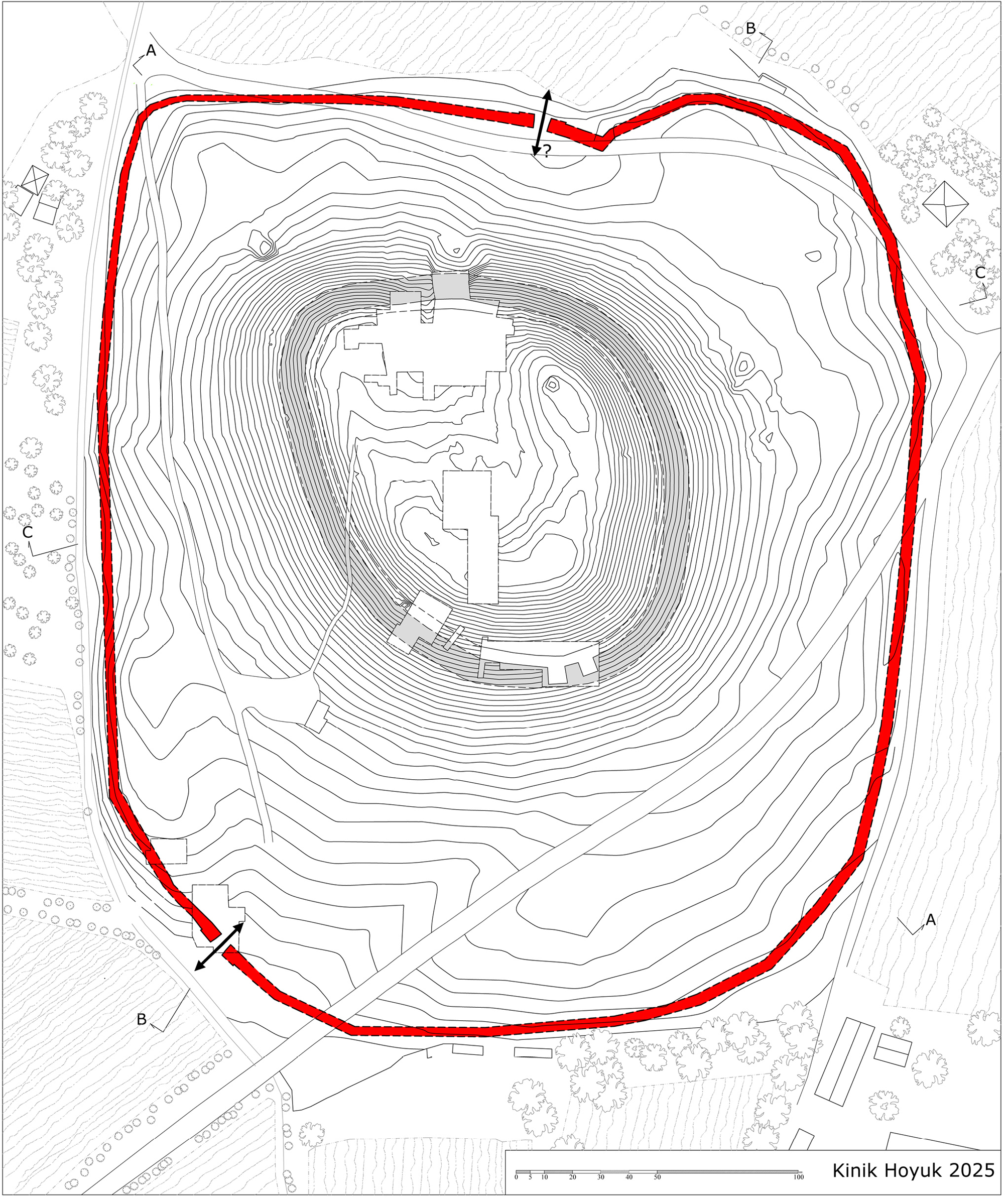
The building technique of the fortification wall differs from the usual “Kastenmauer” used in MBA fortification in Central Anatolia (as in Konya-Karahöyük, Alişar and Kusura, cf. Naumann 1971: 251-253 and 319-325) or in SE Anatolia (as in Tilmen Höyük, Orsi 2022) during this period. The randomly multifaceted shape of the stone blocks, as they come from the quarry, is retained; however, the individual faces are not smoothed and only approximately fitted to one another, producing a bond in the walls. The visible exterior face of the blocks is not worked flat but retains a natural convexity, mortar is absent. This technique is well known in Anatolia (cf. Naumann 1971: 70-73 and fig. 54) and seems to be applied here on a monumental scale. The fortification wall is not equipped with towers, at least along the excavated stretch; instead, it appears to run straight, continuing toward NW. The only tower uncovered within the investigated area seems to be positioned at the city gate. This, too, contrasts with what is known of fortification walls of the same period in Central Anatolia, which are typically characterised by strongly projecting buttresses or towers along their outer face. Although a MBA level has not yet been reached on the acropolis, the scale of fortification in the Lower Town makes a palatial “ residence” on the summit a plausible working hypothesis. Phase 6 thus provides the social and political urban baseline against which later contractions and reconfigurations are measured. A radiocarbon determination of c. 1730 BC (see above) associated with the final use of Phase 6 indicates that the MBA urban episode at Kınık Höyük ended not long after this date, at least in the portion of the Lower Town investigated so far. Analysis of the faunal assemblage indicates that the community in the Lower Town relied heavily on animal husbandry, with consumption dominated by cattle and caprines (sheep/goat). Butchery traces show processing across a range of carcass portions and stages, consistent with a mixed agro-pastoral economy. Paleoethnobotanical evidence for this phase is still limited due to low concentrations in macro-remains. The wood charcoal record is largely dominated by deciduous oak (Quercus), reflecting its use as firewood, which is well documented elsewhere at the site in later periods (Castellano 2021). The seed assemblage is currently too sparse to allow meaningful considerations, other than noting the occurrence of barley.
As the Hittite kingdom consolidated into an empire, the Lower Town at Kınık Höyük shows a clear urban break: above the MBA destruction horizon (Phase 5), deposits are poor and largely erosional or collapse-derived, with no in-situ architecture attributable to this phase, thus the Lower Town, or at least this portion of the town, was probably not inhabited during this period. Thus, following the MBA destruction, the Lower Town appears to have undergone a prolonged interval of non-occupation that extends through the LBA and into the Early Iron Age. No architectural levels securely attributable to these periods have been identified in Area D. The first clear reoccupation of the Lower Town corresponds to Phase 4, dated broadly to the late 10th–9th centuries BC. Thus, between the end of the MBA horizon and this MIA reestablishment, the evidence indicates a sustained hiatus – at least for this sector of the settlement. By contrast, on the acropolis (d’Alfonso in press) the LBA presence is limited but attested: an early fortification phase (Aw.8), radiocarbon-dated to the mid–2nd millennium BC, was later levelled and replaced by Aw.7 around 1000 BC; in sector C3 LBA II level from a small deep sounding yielded a small diagnostic set corroborated by radiocarbon dating. In short, building activity contracts to the summit, while the Lower Town remains non-urban.
Relative to the monumental MBA II baseline, Phase 5 records a break in urban life in the Lower Town and only selective, citadel-focused investment – not a comprehensive rebuild. This aligns with a broader pattern in which imperial consolidation did not entail uniform growth of secondary urban quarters in southern Cappadocia; at Kınık, the LBA presence outside the fortification is materially poor and non-architectural, consistent with abandonment rather than redevelopment. It is therefore difficult to clarify the role – if any – played by a LBA settlement at Kınık Höyük within the Hittite polity. The ceramic horizon outlined above may hint at limited interaction or “contamination” with broader Central Anatolian traditions, yet the current archaeological record does not permit a more precise functional attribution. In the absence of secure architectural levels and primary contexts, the site’s position in regional networks during this period must remain provisional.
In the 9th century BC, southern Cappadocia formed a mosaic of small, internally governed hill-country polities – often termed “canton-states” – between larger spheres to west and south (Phrygia; Neo-Hittite/Luwian states of Tabal and the Cilician gateways) and the expanding Neo-Assyrian world to the east. Power was expressed less through palatial monumentality than through fortified citadels, compact domestic quarters, and control of local roads across intermontane corridors. Contacts intensified and diversified: central-plateau ceramic habits cohered across sites; political pressure from Assyria was episodic, negotiated, and unevenly felt; Phrygia reached its apex farther west, but its influence in southern Cappadocia was selective rather than determinative (d’Alfonso 2017, Matessi 2025, Osborne 2021: 218-9). In this landscape, communities privileged in the Lower Town resilient household economies, light architectural investment, and incremental reuse of inherited topography over wholesale urban redesign. In the Lower Town at Kınık Höyük, Early Iron Age occupation is not (so far) attested; reoccupation of the investigated area belongs to the MIA (Phase 4), when a locally scaled domestic fabric returns – aligned with the Central Anatolian ceramic horizon rather than explicitly Phrygian monumental templates. Rooms such as Dr7/Dr10 are set into and over the collapsed MBA mass; streets and open spaces are re-graded rather than re-planned, producing a workable but non-monumental urban fabric. Whether the entire Lower Town was occupied remains uncertain; in any case, it was neither refortified nor this area was laid out as a planned quarter during this period. Pottery shapes and decoration differ markedly from MBA norms and align with the Central Anatolian MIA ceramic horizon more than with western, “Phrygian” monumental idioms. On the acropolis, early MIA levels (A2.4d–c) show two small rectangular buildings abutting the circuit and a pebble-paved area – a compact, non-palatial citadel layout. Limited Gray Ware (imports and local imitations) and a few Phrygian letters attest selective western links within an otherwise plateau-oriented template (d’Alfonso et al. 2025). Phase 6a (MBA) and Phase 4 (MIA) both yield faunal spectra dominated by cattle and caprines, but their signatures diverge in management and use. In Phase 6a, abundant neonatal/foetal caprines and pigs point to on-site herding and birthing, coupled with routine butchery, light burning/gnawing, and long-term refuse build-up – an integrated agro-pastoral household economy. Bone reworking (e.g., a spindle whorl from a cattle femoral head) further indicates craft activities embedded in domestic routines. By contrast, Phase 4 assemblages reflect regular household consumption with a cleaner, more episodic discard pattern and fewer markers of on-spot husbandry. Notably, Phase 4 introduces processed equids (donkey/horse) and also points to occasional cynophagy, practices not documented in Phase 6a. Overall, Phase 6a suggests sustained, multi-activity use of outdoor spaces, whereas Phase 4 indicates continued stock use but with disposal regimes and dietary breadth that differ – narrower craft signal, yet broader meat sources. These contrasts suggest a transition from intensively co-located husbandry and craft activities in Phase 6a to a Phase 4 occupation in which animal management and waste disposal were more spatially peripheral. This later phase also shows intermittent incorporation of equid and dog meat into the diet, a pattern consistent with contemporary Iron Age sites in Anatolia (Siddiq et al. 2021).
Current palethnobotanical evidence from Operation D remains limited also for Phase 4. Among economic taxa, it is noted the occurrence of free-threshing wheat and barley, alongside single finds of grape seeds. This latter taxon is attested also in the wood charcoal assemblage, pointing to local viticulture by the MIA. The involvement of Kınık in grape farming is well documented elsewhere at site by a rich macrobotanical record (Castellano 2023).
Following the fall of Phrygia and the advance of the Cimmerians c. 720 BC, the region experienced decades of instability marked by raids and shifting spheres of control. By the mid-7th century, Scythian groups replaced or absorbed the Cimmerians, while the expanding Median Empire began to exert influence from the east. The treaty of 585 BC, which set the Halys (Kızılırmak) River as the frontier between Medes and Lydians, effectively placed Cappadocia within a contested borderland until the end of the 6th century (Payne 2023). At Kınık Höyük, in the Lower Town, Phase 3 is characterised by intensive use of ovoid installations and associated circular pits, coupled with a modest domestic unit (Dr19) set into the northern edge of the area. Activity signatures cluster around low-status craft and household tasks; the Phase 3a fills sealing these cuts record progressive disuse and systematic leveling in preparation for the next urban scheme. On the acropolis, during KH-P IV, a multi-room monumental building (Ab1) and a finely engineered basalt-paved entryway with staged platforms and integrated drainage mark a heightened degree of hierarchy and spatial control by the late 7th-6th centuries BC. After Ab1 fell out of use, the area shifted into reuse/squatting (A2.3) and accumulated a compact mudbrick-decay deposit. A balanced reading of the evidence points to a differentiated but non-polarized development. In the Lower Town – at least in its southern sector – Phase 3 indicates a predominantly domestic occupation, more dispersed than in earlier periods and likely coupled with a shift in function toward light processing and maintenance activities. On the acropolis, occupation persists and continues to organize productive tasks, yet with some signs of monumentality: the picture is one of sustained habitation and work rather than overt architectural display. The presence of numerous metal and glass production waste in the filling of the ovoid installations may suggest the presence of a production area in the vicinity during this phase.
Given the close parallels with Sardis contexts (see above), it is plausible that Lydian cultural influence reached Kınık Höyük in the late 7th–6th centuries BC. We frame this as material/technological and stylistic convergence rather than proof of direct political control, consistent with a borderland setting where contacts and fashions could travel faster than institutions. In terms of faunal remains, the assemblage in the Lower Town marks a clear departure from the earlier Phase 4 profile. Whereas Phase 4 shows a relatively standardized, domesticate-focused regime – cattle and caprines dominant, wild taxa scarce, butchery more routine, limited burning, and reduced gnawing – Phase 3 broadens and intensifies resource use. Wild taxa (hare, marten, tortoise, small birds) appear regularly; processing becomes exhaustive across species with heavier gnawing (notably on cattle); and there is unequivocal evidence for hippophagy and cynophagy. Burning remains limited, but carcass treatment is thorough, and a lightly burnt dog baculum suggests non-ordinary practices. In sum, Phase 3 shifts from Phase 4’s narrower, cleaner discard pattern to a more diversified, opportunistic subsistence superimposed on a pastoral base, resulted by either increased occupation intensity or shifts in the social and economic conditions.
In 546 BC Lydia fell to Cyrus and Cappadocia was incorporated into the Achaemenid Empire. One might expect an immediate administrative and material signature at sites in the region (Leloux 2016). At Kınık Höyük, however, both the Lower Town and the acropolis register a break in use. In the Lower Town (Area D), the LIA sequence (Phase 3) ends with 3a fills and broad levelling deposits sealing the ovoid installations; notably, the ceramic horizon closes by the end of the 6th/very early 5th century BC and yields no diagnostic Achaemenid markers. Consequently, the immediately following Phase 2b is interpreted as a non-use interval, i.e., a local hiatus between the LIA horizon and the next securely attested phase. On the acropolis, late 7th–6th-century Phase A2.4a–b culminates with the multi-room monumental Building Ab1 and its basalt-paved entryway; after Ab1’s de-functionalization, reuse/squatting (A2.3) occurs. Critically, a compact mudbrick-decay deposit (A5697) accumulated on the summit before construction of the defensive wall against that decay layer, demonstrating a summit-wide hiatus prior to reorganization (d’Alfonso et al. 2025). This hiatus may reflect a reorientation of long-distance corridors under the Achaemenids: the Royal Road from Susa to Sardis (French 1998) increasingly channelled traffic along more northerly routes across Central Anatolia, reducing reliance on the Cilician Gates; Kınık Höyük – situated off these redirected arteries – may thus have been bypassed, helping to explain the gap in occupation.
After the Achaemenid hiatus, Kınık Höyük underwent a selective Hellenistic refoundation operating at two scales. In the Lower Town (Phase 2a), the revival does not take the form of a new monumental street grid, but of a ground-up reset of the landscape: extensive levelling and terracing stabilize the inherited MBA topography, redefine circulation, and create workable thresholds. The irregular “serpentine” wall functions as a major terrace/retaining element; a second wall line at compatible elevation supports this regrading, and a clear exterior surface to the south marks the new ground-use. Small, practical spaces – including Dr11, with fire installations and associated iron tools – signal a residential/craft reactivation rather than a prestige rebuild. In the adjacent D1 sector, a house plausibly of Early Hellenistic date corroborates the residential character of this reoccupation.
On the acropolis, construction of the Great Plaza – very likely a civic-sacral installation – provides the “upper” counterpart to the reset below. Taken together, the plaza above and the terraced, re-engineered ground below amount to a site-wide reset: not a palatial refoundation, but a coordinated reorganization that realigns surfaces, grades, and routes, pairing civic emphasis on the summit with domestic and artisanal functionality in the Lower Town. The sanctuary sequence is anchored by ceramics, coins, metals, and radiocarbon to a mid-second to late 1st century BC horizon (Trameri, d’Alfonso 2020); after this, the sanctuary area – like most of the site – was rearranged. We therefore propose that the terrace-and-route reset documented in the Lower Town of Phase 2a is coeval with this reorganization. The proposed linkage between the Lower Town sequence (especially Phase 2a) and the acropolis sanctuary/plaza sequence (KH-P II) is provisional. Ceramic seriations for both areas are under active study; diagnostic markers in Area D remain limited; and no secure tie-points (e.g., sealed cross-area interfaces, closely bracketing 14C pairs, or stratified numismatics) compel strict synchrony. Pending full ceramic review – and additional dating and petrographic work – the connection should be treated as a working hypothesis, not a demonstrated equivalence. Kınık Höyük presents the local, infrastructural face of that regional reset: a civic-sacral surface on the summit paired with a pragmatic, terraced fabric below – less a grand refoundation than a coordinated reactivation aligned with Cappadocia’s late Hellenistic statecraft. The early Hellenistic reorganization observed at Kınık Höyük plausibly aligns with the wider Ariarathid program of urban refoundation and dynastic “branding” in Cappadocia. Ancient and modern sources document the re-naming and re-positioning of key centers under Ariarathid rule, practices consistent with royal strategies of marking authority and managing urban nodes (Cohen 1995, entries on Mazaka/Eusebeia and Tyana/Eusebeia). While direct administrative links to Kınık Höyük remain to be demonstrated archaeologically, the site’s Hellenistic-phase layout fits the period’s regional pattern of selective urban renewal.
Phase 1 is attested but sparsely documented. In D6, excavation just below topsoil revealed a stone-paved surface, likely a stretch of street. In eastern D2, a large pit yielded glass fragments, hinting at a late (possibly Roman) horizon, though the finds are too scant for firm dating. Stratigraphically, all remains are later than Phase 2; their disturbance and paucity of diagnostics preclude tighter attribution. Any link to the acropolis sequence is, for now, tentative pending fuller ceramic and absolute dating work. Given the number and complexity of reworkings documented in the acropolis sanctuary area, some level of activity may have continued beyond the Hellenistic phase, possibly into the early Roman provincial period: a city that reuses its depths, retools its heights, and pauses when the world’s roads no longer pass its gate.
11. Conclusions
The Lower Town at Kınık Höyük is best understood as an alternation of persistence and rupture across time. The MBA II establishes a fortified, monumental frontage whose footprint – and collapsed mass – creates topographic and material legacies repeatedly re-used by later occupations (e.g., building materials, inherited surface gradients), even after an abrupt break marked by destruction and abandonment. The LBA (Phase 5) forms a discontinuous horizon: materially sparse, spatially confined, and likely separated from later use by a hiatus. With the Iron Age, occupation resumes on a reduced scale: household practices continue (light architecture, piecemeal surfacing) while the urban form does not return to fortification or planned rebuilding, with a progressive withdrawal in 4a. In Phase 3b, work areas (ovoidal installations, circular pits) cluster with a domestic unit (Dr19), indicating continuity of domestic/craft activities (notably textile-related), followed by a functional break: installations fall out of use and are deliberately infilled/levelled – locally with metal and possibly vitreous slags – preparing a new surface regime. During the Hellenistic Phase reasserts control over the terrain through a serpentine terracing wall , an exterior surface to the south, and small craft-oriented structures (e.g., Dr11): a renewed yet reorganized occupation that stabilizes the surface without reinstating Bronze Age monumentality. During the latest occupation of the area a late street paving and associated walls in the northern trench and a Roman-period disturbance, suggest episodic later reuse rather than sustained urban investment.
The faunal assemblages from the Lower Town also demonstrate both long-term continuity and notable diachronic variation in subsistence and economic organization from the MBA through the Hellenistic period. Across all phases, animal exploitation remained firmly based on domestic livestock – especially cattle and caprines – at the core of household economies. The MBA assemblage points to a stable agro-pastoral system with on-site herding and routine household-level management. In the Iron Age, particularly in the LIA, subsistence practices became more diversified and intensive, incorporating “unconventional” resources such as horses, donkeys, and dogs – suggesting greater flexibility and adaptive responses to shifting social, economic, or environmental conditions. The smaller Hellenistic assemblage, by contrast, indicates a return to a narrower, livestock-focused economy.
Overall, the sequence depicts a landscape where enduring practices (domestic/craft work, material reuse, continued reliance on inherited routes and slopes) coexisted with punctuated disruptions (abandonment, levelling, shifts in scale and layout), culminating in a Hellenistic reconfiguration that stabilised the surface without restoring earlier defensive grandeur. Kınık’s trajectory is not one of linear growth, but of selective returns.
References
Akkuzu Z. 2018, The Late Iron Age Pottery from Kaman-Kalehöyük, MA thesis, Ankara, Bilkent University.
Aklan İ., Akçay A. 2023, Kırsalın Öyküsü: Geç Demir Çağı’nda Ovaören, Çukurova Üniversitesi Sosyal Bilimler Enstitüsü Dergisi 32 (3): 20-41.
Aykurt A., Erkanal H. 2016, Archaeological Evidence for an Early Second Millennium BC Potter’s Kiln at Liman Tepe, Belleten 80 (287): 1-22.
Barjamovic G. 2014, The size of Kanesh and the demography of early Middle Bronze Age Anatolia, in L. Atici, F. Kulakoğlu, A. Fairbairn, G. Barjamovic (eds), Current Research at Kultepe-Kanesh: An Interdisciplinary and Integrative Approach to Trade Networks, Internationalism, and Identity, Atlanta, Lockwood Press: 55-68.
Barjamovic G. 2022, Before the Kingdom of the Hittites: Anatolia in the Middle Bronze Age, in K. Radner,N. Moeller and D. T. Potts (eds), The Oxford History of the Ancient Near East: Volume II: Volume II: From the End of the Third Millennium BC to the Fall of Babylon, New York Oxford University Press, online edition.
Barjamovic G., Fairbairn A. 2018, Anatolian Wine in the Middle Bronze Age, Die Welt des Orients 48 (2): 249-284.
Bosana-Kourou P. 1979, The Sphinx in Early Archaic Greek Art, PhD thesis, Oxford, University of Oxford.
Bossert E.-M. 2000, Die Keramik phrygischer Zeit von Boğazköy: Funde aus den Grabungskampagnen 1906, 1907, 1911, 1912, 1931 - 1939 und 1952 - 1960, Boğazköy-Ḫattus̆a, Mainz, von Zabern.
Cahill N. D (ed) 2010, The Lydians and their World - Lidyalilar ve dunyalari, Istanbul, Yapi Kredi Yayinlari.
Castellano L. 2021, A new anthracological sequence from Niğde-Kınık Höyük (Turkey): woodland vegetation and arboriculture in southern Cappadocia from the Late Bronze Age to the Ottoman Period, Archaeological and Anthropological Sciences 13 (49), https://doi.org/10.1007/s12520-021-01284-6.
Castellano L. 2022, Farming the Land of Hatti: a socio-economic history of agriculture in central Anatolia from the Bronze Age to the Hellenistic period, PhD thesis, New York, New York University.
Castellano L. 2023, Grapes and wine in pre-Roman Anatolia: evidence of large-scale viticulture from southern Cappadocia, the land of the storm-god of the vineyard, Journal of Near Eastern Studies 82 (2): 171-196.
Castellano L., Campana D., Crabtree P., Gürel A., Kuzucuoğlu C., Matessi A., d’Alfonso L. 2023, A Diachronic View on the Anatolian Landscape: Environment and Economy from the Bronze Age to the Ottoman Period in the Northern Tyanitis (Southern Cappadocia, Turkey), in N. Marchetti, M. Campeggi, F. Cavaliere, C. d’Orazio, G. Giacosa, E. Mariani (eds), Proceedings of the 12th International Congress on the Archaeology of the Ancient Near East. vol.1, Bologna, Harrassowitz: 45-57.
Cohen G. M. 1995, The Hellenistic Settlements in Europe, the Islands and Asia Minor, Berkeley, the University of California press.
Coldstream J. N., Catling H.N., Carington-Smith J., Cavanagh W.G., Cocking J., Evely R., Higgins R.A., Howell R.J., Liddy D.J., Moignard E., Musgrave J.H., Platon N., Snodgrass A., Smyth D., Wall-Growther Webb V. (eds) 1996, Knossos North Cemetery Early Greek Tombs, The British School at Athens. Supplementary Volumes, London, British School at Athens.
Cook, R. M., Dupont, P. 2003, East Greek Pottery, 2nd edition, London, Routledge.
d’Alfonso L., Guney A., Fox-Zampicolli L. 2025, New Insights on the 1st Millennium BCE Occupation of the Citadel at Niğde-Kınık Höyük. Excavations 2022-2024 in Sectors A2 and Ed, Athenaeum 113: 266-284.
d’Alfonso L. 2017, Ten Years of Research in Southern Cappadocia: History, Archaeological Investigations, and Ancient Landscapes, News from the Lands of the Hittites 1: 59–76.
d’Alfonso, L. in press, Between core and periphery: Archaeology of sovereignty of the Land of Tuwanuwa at the time of the Hittite Great Power, Anatolian Studies.
Davis P.H. 1965-1985, Flora of Turkey, Edinburgh, Edinburgh University Press.
Dupré S. 1983, Porsuk 1: La céramique de l’âge du Bronze et de l’âge du Fer, Éditions Recherche sur les Civilisations, Mémoire 20, Paris, Éditions Recherche sur les Civilisations.
Durbin G. E. S. 1971, Iron Age Pottery from the provinces of Tokat and Sivas, Anatolian Studies 21: 99–124.
Ekmen F.G. 2023, Acemhöyük in the Old Hittite Kingdom: From the Commercial Center to Rural Settlement, Aula Orientalis 41(2): 161-181.
Emre K. 1963, The pottery of the Assyrian Colony Period according to the building levels of the Kaniş Karum, Anadolu 07: 87-153.
Emre K. 1966, The Pottery from Acemhöyük, Anadolu 10: 99-153.
Ergürer H. 2018, Gözeli Tepesi Höyük Demir Çağı Seramikleri., TÜBA-AR Türkiye Bilimler Akademisi Arkeoloji Dergisi 22: 63–93.
Fantoni C. 2025, Living in the Lower Town: a study of a Middle Iron Age room at Niğde-Kınık Höyük, PhD thesis, Pavia, Università degli Studi di Pavia.
French D. 1998, Pre- and Early-Roman Roads of Asia Minor. The Persian Royal Road, Iran 36: 15-43. Genz H. 2001, Iron Age Pottery From Çadır Höyük, Anatolica 27: 159-170.
Gates M.H. 2001, Potmarks at Kinet Höyük and the Hittite Ceramic Industry, in É. Jean, A.M. Dinçol, and S. Durugönül (eds) La Cilicie : Espaces et pouvoirs locaux (2e millénaire av. J.-C. – 4e siècle ap. J.-C.), Varia Anatolica 13. Paris, De Boccard: 137-157.
Genz H. 2004, Büyükkaya I: Die Keramik der Eisenzeit. Funde aus den Grabungskampagnen 1993 bis 1998, Boğazköy-Hattuša 21, Mainz am Rhein, von Zabern.
Gökçe Köker E., Doğanay O. 2021, Isaura ve Çevre Yerleşimlerden Demir Çağı Boyalı Kapları. Colloquium Anatolicum, Colloquium Anatolicum 20: 139-162.
Goldman H. (ed) 1956, Excavations at Gözlü Kule, Tarsus: Vol. II: From the Neolithic through the Bronze Age, Princeton, NJ, Princeton University Press.
Goldman H. (ed) 1963, Excavations at Gözlü Kule, Tarsus: Vol. III: The Iron Age, Princeton, NJ, Princeton University Press.
Gündüz R. 2019, Gökhöyük Bağları Höyüğü Demir Çağı Seramiği, PhD thesis, Konya, Selçuk Üniversitesi.
Highcock N., Matessi A. 2021, The Early Bronze Age at Kınık Höyük (Niğde): a preliminary analysis, in F. Kulakoğlu, G. Kryszat and C. Michel, Cultural Exchanges and Current Research at Kültepe and its Surroundings. Kültepe International Meetings 4 Turnhout, Brepols: 275-292.
Jacomet S. 2006, Identification of cereal remains from archaeological sites, Basel University, IPAS.
Kamış Y. 2018, Acemhöyük Buluntuları Işığında Erken Tunç Çağı’nda Orta Anadolu’nun Güneyinde Çark Yapımı Seramiğin Ortaya Çıkışı, Adalya 21: 59-84.
Kara S. 2019, Ovaören-Yassıhöyük Demir Çağı hayvan figürlü seramikleri. MA thesis, Ankara Hacı Bayram Veli Üniversitesi.Kealhofer L., Grave P. 2011, The Iron Age on the Central Anatolian Plateau, in S. R. Steadman and G. McMahon (eds), The Oxford Handbook of Ancient Anatolia, Oxford, Oxford University Press: 415-443.
Kourou N. 2011, Following the Sphinx: Tradition and Innovation in Early Iron Age Crete, in G. Rizza (ed), Identità culturale, etnicità, processi di trasformazione a Creta fra ‘Dark Age’ e Arcaismo. Convegno di studi per i cento anni dello scavo di Priniàs, 1906–2006 (Atene 9-12 novembre 2006), Catania, CNR: 165-177.
Kulakoğlu F., Kangal K. 2012, Anatolia’s prologue. Kultepe Kanesh Karum. Assyrians in Istanbul, Istanbul, Kayseri Municipality.
Kulakoğlu F., Peyronel L., Oselini V., Vacca A. 2024, The Settlement Sequence of Kültepe from the Late Early to the Middle Bronze Age. Stratigraphic and Ceramic Periodization from Recent Excavations in the Southern Sector of the Mound, in F. Kulakoğlu and C. Michel (eds), Kültepe at the Crossroads between Disciplines: 207-225.
Lanaro A., Castellano L., Highcock N., Mantovan A., d’Alfonso, L. 2020, South-Central Anatolia during the Iron Ages: a diachronic view from Kınık Höyük (Niğde), in A. Otto, M. Herles and K. Kaniuth (eds), Proceedings of the 11th International Congress on the Archaeology of the Ancient Near East., Wiesbaden, Harrassowitz. 2: 215-228.
Leloux K. 2016, The Battle of the Eclipse (May 28, 585 BC): A Discussion of the Lydo-Median Treaty and the Halys Border, Polemos 19 (2): 31-54.
Manuelli F., Mielke D.P., 2022, Introduction – Throwing Some Colour on a Plain World in F. Manuelli and D. P. Mielke (eds), Late Bronze Age Painted Pottery Traditions at the Margins of the Hittite State, Oxford, Archaeopress: 1-21.
Massa M., Bachhuber C., Şahin F., Erpehlivan H., Osborne J.F., Lauricella A.J., 2020, A landscape-oriented approach to urbanisation and state formation in the Konya and Karaman Plains, Turkey, Anatolian Studies 70: 45-75.
Matessi A. 2025, The Syrian and the Anatolian: Cultural and political frontiers in the post-Hittite Eastern Mediterranean (ca. 1200-700 BCE), Aula Orientalis 43/1: 55-76.
Matsumura K. 2005, Die eisenzeitliche Keramik in Zentralanatolien – auf der Grundlage der Ausgrabung von Kaman-Kalehöyük, PhD thesis, Berlin, Freie Universität Berlin.
Mellaart J., Lloyd S. 1965, Beycesultan. Vol. 2, Middle Bronze Age architecture and pottery, London, British Institute of Archaeology at Ankara.
Morgan K. R., Soldi S. 2021, Middle bronze age Zincirli: An interim report on architecture, small finds, and ceramics from a monumental complex of the 17th century B.C.E., Bulletin of the American Schools of Oriental Research 385 (1): 53–86.
Mühlenbruch T. 2014, Hethitische Keramik im Kontext: das Gebäude B von Kayalıpınar und die Nutzung institutioneller Gebäude des 2. Jt.s v. Chr. im ostmediterranen Raum, Marburger Studien zur Vor- und Frühgeschichte Band 26, Rahden: Marie Leidorf.
Müller-Karpe A. 1988, Hethitische Töpferei der Oberstadt von Hattuša: ein Beitrag zur Kenntnis spät-grossreichszeitlicher Keramik und Töperferbetriebe unter Zugrundelegung der Grabungsergebnisse von 1978-82 in Boǧazköy, Marburger Studien zur Vor- und Frühgeschichte Band 10, Marburg: Hitzeroth.
Naumann R. 1971, Architektur Kleinasiens von ihren Anfängen bis zum Ende der hethitischen Zeit, Tübingen, E. Wasmuth.
Ökse A. T. 2019, The Eastern Border of Phrygia, in G. R. Tsetskhladze (ed), Phrygia in Antiquity: from the Bronze Age to the Bizantine period, Leuven, Paris, Bristol, Peeters: 161-188.
Orsi V. 2022, Excavations at Tilmen Höyük. Vol. 1: The fortification system in the Lower Town, Bologna, Ante Quem.
Osborne J. 2021, The Syro-Anatolian City-States, Oxford, Oxford University Press.
Özgüç T. 1978, Excavations at Masat Hoyuk and investigations in its vicinity = Masat Hoyuk kazilari ve cevresindeki arastirmalar, Ankara, Türk Tarih Kurumu Basımevi.
Payne A. 2023, The Kingdom of Lydia, in K. Radner, N. Moeller and D. T. Potts (eds), The Oxford History of the Ancient Near East Volume V: The Age of Persia, Oxford University Press, online version.
Postgate J.N., Thomas D. (eds) 2007, Excavations at Kilisetepe, 1994–98: From Bronze Age to Byzantine in Western Cilicia, Ankara, British Institute at Ankara.
Postgate J. N. 2007, The Ceramics of Centralisation and Dissolution: A Case Study from Rough Cilicia, Anatolian Studies 57: 141-150.
Powroznik K. J. 2010, Die Eisenzeit in Kuşaklı, Rahden, M. Leidorf.
Pucci M., Alvaro C., Bartolozzi S., Carletti M., Castellano L., Fantoni C., Lentini F., Montesanto M., Yolaçan B. 2023, Living in the Lower Town at Kınık Höyük (Niğde). Preliminary Report on the 2021-2022 Campaigns in Anatolia, Asia Anteriore Antica. Journal of Ancient Near Eastern Cultures 5: 81-130.
Pucci M., Yolaçan B., D’Alfonso L., Karadavut D., Keloğlu B. 2024, Niğde-Kinik Höyük 2022 Yili Kazi Çalişmalari in C. Keskin (ed), 43. Uluslararası Kazı, Araştırma ve Arkeometri Sempozyumu. Kazi Sonuclari Toplantisi. Cilt 4, Ankara, Kültür Varlıkları ve Müzeler Genel Müdürlüğü: 443-459.
Pustovoytov K., Riehl S., Mittmann S. 2004, Radiocarbon age of carbonate in fruits of Lithospermum from the early Bronze Age settlement of Hirbet ez-Zeraqon (Jordan), Vegetation History and Archaeobotany 13: 207-212.
Ramage A., Ramage N.H., Gürtekin-Demir R.G. 2021, Ordinary Lydians at Home: The Lydian Trenches of the House of Bronzes and Pactolus Cliff at Sardis, Archaeological Explorations at Sardis. Report 8 Harvard, Harvard University Press.
Renfrew J. M. 1973, Palaeoethnobotany: The Prehistoric Food Plants of the Near East and Europe, Columbia, Columbia University Press.
Sams G. K. 1994, Gordion Excavations 4. The Early Phrygian Pottery, Gordion Excavations Final Reports Philadelphia, The University Museum.
Schaus P. G. 1992, Imported West Anatolian Pottery at Gordion, Anatolian Studies 42: 151-1.
Schmidt E. 1932, Researches in Anatolia 4. The Alishar Hüyük Season of 1928 and 1929. Oriental Institute Publication 19, Chicago, Oriental Institute.
Sharifzadeh M., Moghaddam E. 2018, A Comparative Study of the Sphinx in Achaemenid Art and Seljuk Art, Bagh-E Nazar 15: 53-70.77.
Siddiq, A. B., Onar, V., Mutuş, R., Poradowski, D. 2021, The Iron Age dogs from Alaybeyi Höyük, Eastern Anatolia, Animals 11: 1163. https://doi.org/10.3390/ani11041163
Summers G. D. 2021, Excavations at the Cappadocia gate: Kerkenes final reports 1, with contributions by Susanne Berndt, Yilmaz Selim Erdal, Evangelia Piskin, Yasemin Özarslan, Noël Siver, Francoise Summers, Robert Tate, and Nilüfer Baturayoğlu Yöney, Oriental Institute Publication 145, Chicago, Oriental Institute.
Summers G. D. 2022, Excavations at the Palatial Complex: Kerkenes Final Reports 2, with contributions by Susanne Berndt, Ahmet Çinici, Yılmaz Selim Erdal, Evangelia Pişkin, Noël Siver, and Françoise Summers, OIP 148 Chicago, Oriental Institute.
Summers M. E. F., Ahmet K., Summers G.D. 1995, The Regional Survey at Kerkenes Dağ: An Interim Report on the Seasons of 1993 and 1994, Anatolian Studies 45: 43–68.
Tezcan B. 1992, 1969 Göllüdağ Kazısı, Türk Arkeoloji Dergisi 30: 1–30.
Trameri A., d’Alfonso L. 2020, The ›Sacred City‹ of Kınık Höyük: Continuity and Change in Cappadocia (Turkey) between the Late Achaemenid and Late Hellenistic Periods, in W. Held (ed.), The Transition from the Achaemenid to the Hellenistic Period in the Levant, Cyprus, and Cilicia: Cultural Interruption or Continuity?, Marburg, Eigenverlag des Archäologischen Seminars der Philipps-Universität: 65-81.
Umurtak G. 1996, Korucutepe - II: 1973-1975 Dönemi Kazilarinda Bulunmus Olan Hitit Çagi Çanak Çömlegi, Ankara, TTK.
Üyümez M., Koçak Ö., İlaslı A., Çay T., İşcan F. 2007, Afyonkarahisar’ın Doğusunda Önemli Bir Orta Tunç Çağı Nekropolü: Dede Mezarı, Belleten 262: 811-842.
von der Osten H. H. 1937, Researches in Anatolia 9. The Alishar Hüyük Seasons of 1930-1932, Part 3 , with contributions by Wilton Marion Krogman and Others, OIP 30 Chicago, Oriental Institute.
von der Osten H. H., Schmidt E. 1932, Researches in Anatolia 3. The Alishar Hüyük Season of 1927, Part 2, OIP 7 Chicago, Oriental Institute.
Williams D. 1973, Flotation at Siraf, Antiquity 47: 288-292.
Yılmaz A. M. 2015, Vezirköprü/Oymaağaç Höyük Demir Çağı Seramikleri. PhD thesis, Erzurum, Atatürk Üniversitesi.
Yolaçan B., Pucci M., d’Alfonso L., Keloğlu B., Karadavut D. 2025, Kinik Höyük 2023 Yili Çalişmalari, in C. Keskin (ed), 44. Uluslararası Kazı, Araştırma ve Arkeometri Sempozyumu. Kazi Sonuclari Toplantisi. Cilt 5, Ankara, Kültür Varlıkları ve Müzeler Genel Müdürlüğü. 5: 307-324.
1 Most recent publication on the acropolis, cf. Lanaro et al. 2020; Pucci et al. 2024, d’Alfonso et al. 2025; Yolaçan et al. 2025. For the excavations carried out in the lower town until 2021 cf. Highcock, Matessi 2021.
2 Ceramic experts who contributed in this paper: MA Deniz Dernek (Phase 4, Room Dr10), Dilara Karadavut (Phase 3a,), Dr. Caterina Fantoni (Phase 4, Room Dr7) also registrar and responsible of the inventory, MA Federica Lentini (Phase 6a Area Ds18, also field supervisor) contributed in this paper on pottery assemblages from different periods; these in part correspond to specific academic works on the assemblage from the lower town: Caterina Fantoni PhD at the University of Pavia on the Iron Age pottery inventory of Room Dr7, completed in 2025; Federica Lentini Postgraduate Diploma in Archaeology and Cultural Heritage on the Middle Bronze Age assemblage from the Lower Town, in progress; Dilara Karadavut, Master’s Thesis on the Pottery inventory from the Iron Age installation from Phase 3a, completed 2025;
3 Prof. Abu Siddiq is the zooarchaeologist working on the faunal remains of the site from 2022.
4 Dr. Lorenzo Castellano is the specialist for paleoethnobotany and contributed in this paper on this subject; Prof. Mine Sezgül, Dr. İsmail İşintek, Prof. Funda Akgün are the geologists currently working on the reconstruction of the environment at the site (since 2024).
5 In addition to the ones mentioned above, field supervisors of the areas in the Lower Town (2023-2024) and contributors on the stratigraphy in this paper: MA Camilla Corazzi, Elia Guerrieri Canovi, Dr. Mariacarmela Montesanto (all University of Florence). MA Sofia Bartolozzi on metal production and metal slags; MA Margherita Carletti, field supervisor and topographer, drafted all architectural plans of this contribution; Prof. Marina Pucci coordinated the research, integrated the contributions, and is responsible for the final synthesis and conclusions.
6 Fazlı Açikgöz and Fatma Bayram have been the conservators in charge during these two years, Paola Vertuani (illustrator) together with Dr. Caterina Fantoni and MA Federica Lentini have been reassembling and documenting the vessels, Figen Türker (photographer) documented small finds and pottery in 2023 and 2024.
7 Paleoethnobotanical samples were processed using machine assisted flotation, Siraf-Type, (Williams 1973), with mesh size of 1-mm for the heavy fraction and <0.2 mm for the light fraction. The light fraction was subsequently passed through a column of stackable geological sieves (4, 2, 1, 0.5, and 0.25-mm). The 4, 2, 1, 0.5-mm fractions were subjected to carpological analysis. Analyses were conducted using a stereomicroscope (AMScope Stereo Zoom, 3.5X to 90X magnification range). Wild and weed taxonomy follows the Flora of Turkey (Davis 1965-1985). Economic plant taxonomy is based on Renfrew (Renfrew 1973) and Jacomet (Jacomet 2006). Economic plants were quantified by count and weight. In the case of cereals, specimens conserving the embryo were considered as whole. For pulses, each cotyledon was assigned a count value of 0.5. Fruit and nut preserving more than the 50% of the whole are counted as 1. In the 4 and 2-mm fraction wood charcoal and amorphous fragments are sorted and weighed separately. Wood charcoal analysis was conducted on the 4mm fraction. Specimens were identified on the three fundamental sections, manually exposed and observed under a reflected light microscope (Meiji MT7530) equipped with x5, x10, x20, x50 lenses and a dark- and bright-field illumination system.
8 Two additional fire installation did not yield complete vessels.